Real-time rain information inquiry WebGIS system framework rapid building method

A system framework and construction method technology, applied in the field of GIS system, can solve the problems of small scope of use, high installation and deployment difficulty, high cost, etc., to achieve the effect of improving efficiency and security, avoiding repeated development work, and simplifying steps

Inactive Publication Date: 2018-11-13
HOHAI UNIV
View PDF2 Cites 1 Cited by
  • Summary
  • Abstract
  • Description
  • Claims
  • Application Information

AI Technical Summary

Problems solved by technology

The traditional real-time rainwater situation query GIS system framework is complicated to build, expensive to install and deploy, small in scope of use, difficult to share information technology, and repetitive highly complex development processes also lead to waste of labor for water conservancy workers

Method used


Image

  • Real-time rain information inquiry WebGIS system framework rapid building method

Examples


Embodiment Construction

[0025] The present invention will be further described below in conjunction with the accompanying drawings. The following examples are only used to illustrate the technical solutions of the present invention more clearly, but not to limit the protection scope of the present invention.

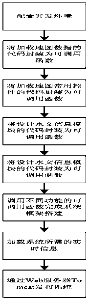
[0026] Such as figure 1 As shown, a rapid construction method of a real-time rainwater situation query WebGIS system framework includes the following steps:

[0027] 1) Configure the development environment.

[0028] Download the latest Openlayers development library from the Openlayers official website as the JavaScript class library package for system development, download the jQuery and BootStrap development library as the overall framework of the web page, download the layer development library as a web page pop-up layer plug-in, and download the echarts development library as a visual chart plug-in ; Create a new .js file to encapsulate all callable functions; create a new .css file to s...


PUM


Abstract

The invention discloses a real-time rain information inquiry WebGIS system framework rapid building method. The method comprises the steps of configuring a development environment; packaging codes forloading map data into a callable function; packaging codes for loading map commonly used controls into a callable function; packaging codes for designing a hydrological information module into a callable function; building a real-time information database; finishing system framework building by calling the callable functions with different functions; loading real-time information needed by the system; and issuing the system by a Web server Tomcat. Compared with the traditional GIS system building, an efficient, light and convenient development mode which greatly simplifies the steps, improvesthe system running efficiency, safety and transportability, avoids most repeated development work and enables developers to focus their more development vigor on research of internal mechanism of water conservancy science, is provided.

Description

technical field [0001] The invention relates to a method for quickly constructing a WebGIS system framework for real-time rainwater condition inquiry, and belongs to the technical field of GIS systems. Background technique [0002] With the advent of new information technology in the "Internet +" era, water conservancy informatization is also developing from "digital water conservancy" to "smart water conservancy". The hydrological information real-time rainwater condition query GIS system is an indispensable component module of the smart water conservancy platform. The traditional real-time rainwater situation query GIS system framework is complex to build, expensive to install and deploy, small in scope of use, difficult to share information technology, and repetitive highly complex development processes also lead to waste of labor for water conservancy workers. Contents of the invention [0003] In order to solve the above-mentioned technical problems, the present inve...

Claims


Application Information

Patent Timeline
Patent Type & Authority Applications(China)
IPC IPC(8): G06F8/34G06F8/71
CPCG06F8/34G06F8/71
Inventor 肖敬董增川李宜雪胡启玲朱寒松马超
Owner HOHAI UNIV
Why Eureka
Try Eureka