Unmanned aerial vehicle system and method for estimating industrial area PM elevated straight row source intensity

A technology of unmanned aerial vehicles, industrial areas, applied in the field of unmanned aerial vehicle systems, to achieve the effect of high accuracy and resolution, easy operation, and improved accuracy

Active Publication Date: 2018-11-16
潘小乐 +2
View PDF10 Cites 7 Cited by
  • Summary
  • Abstract
  • Description
  • Claims
  • Application Information

AI Technical Summary

Problems solved by technology

[0007] The purpose of the present invention is to provide a kind of unmanned aerial vehicle system that is used for estimating the PM overhead direct discharge source strength of industrial area, thus solves the aforementioned problems existing in the prior art

Method used


Image

  • Unmanned aerial vehicle system and method for estimating industrial area PM elevated straight row source intensity
  • Unmanned aerial vehicle system and method for estimating industrial area PM elevated straight row source intensity
  • Unmanned aerial vehicle system and method for estimating industrial area PM elevated straight row source intensity

Examples


Embodiment 2

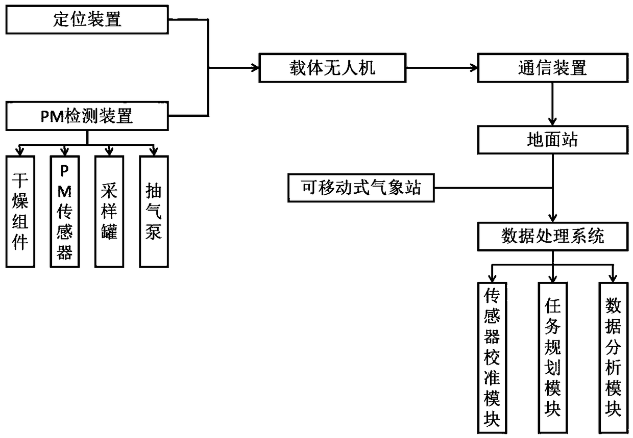
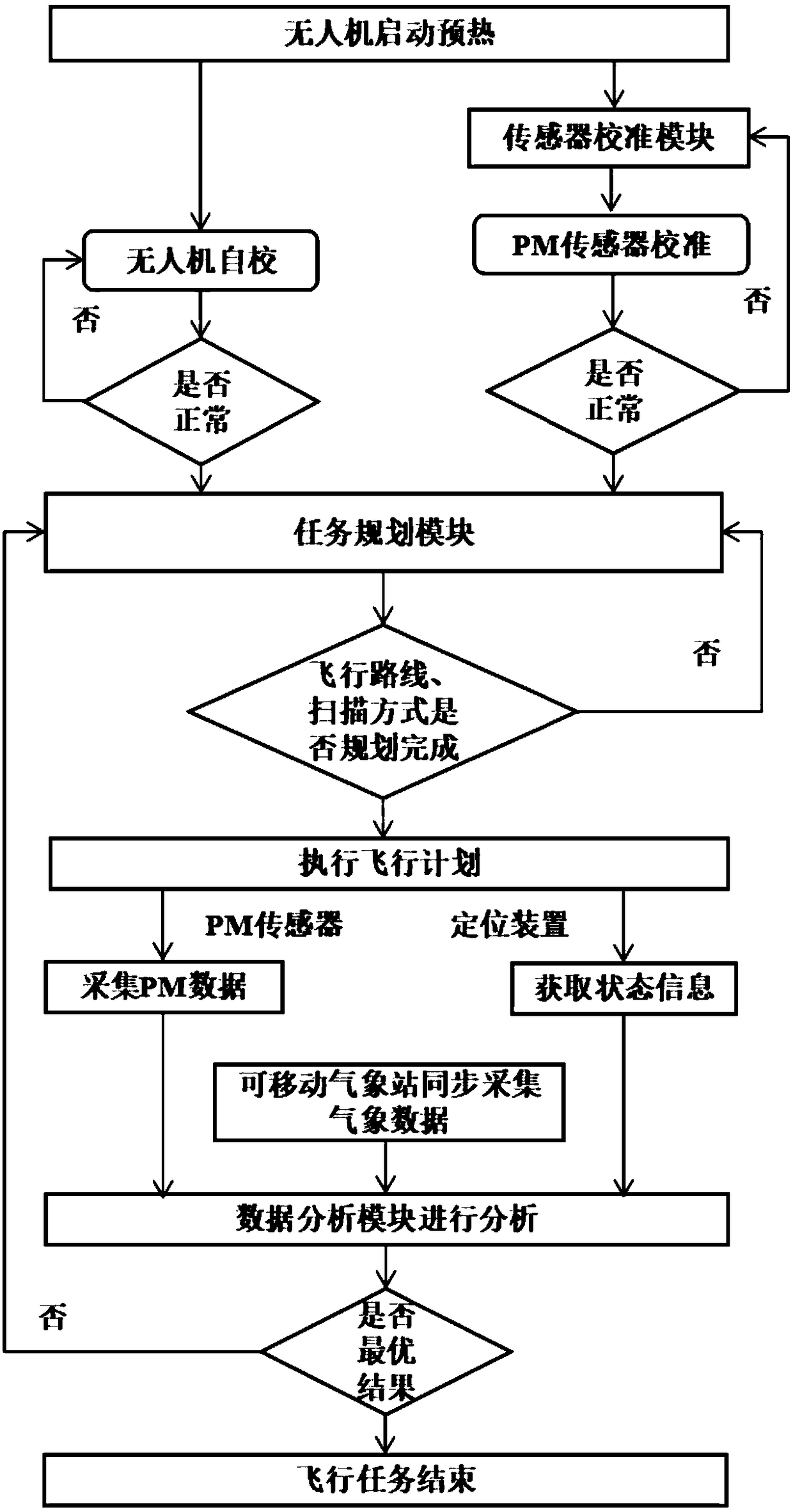
[0033] This embodiment provides a method for estimating the intensity of PM overhead direct discharge sources in industrial areas. The working process is as follows: figure 2 shown, including the following steps:

[0034] The S1 drone starts to warm up, and the drone performs self-calibration on the avionics, flight control and other modules. Based on the standard PM detector, the sensor calibration module performs standard curve fixed-point calibration on the PM sensor. After everything is normal, the drone to fly;

[0035]The mission planning module uses wind direction, wind speed, temperature, pressure, atmospheric stability, and the height of PM overhead emission sources as input parameters to plan reasonably the flight area and scanning mode of the UAV.

[0036] The S2 UAV executes the flight plan, the PM sensor collects PM concentration data, the positioning device collects information such as the height, latitude and longitude of the UAV, and the mobile weather statio...


PUM

PropertyMeasurementUnit
specific surface areaaaaaaaaaaa

Abstract

The invention discloses an unmanned aerial vehicle system and method for estimating industrial area PM elevated straight row source intensity, and belongs to the field of atmospheric pollution control. The system comprises a carrier unmanned aerial vehicle, a PM detection device, a positioning device, a communication device, a movable meteorological station, a ground station, a task planning module, a sensor calibration module and a data analysis module. When the unmanned aerial vehicle works, the sensor calibration module is used for calibrating a PM sensor, and the task planning module is used for planing a flight mode; the unmanned aerial vehicle executes the flight mode, PM data, unmanned aerial vehicle position information and meteorological data are collected and together imported into a data processing system, and the PM elevated straight row source intensity is calculated through the data processing system. The system can estimate the industrial area PM elevated straight row source intensity, and the system has the advantages of being high in automation degree and precision, easy to operate and the like and can provide important data support and reference bases for atmospheric pollutant source analysis, emission inventory making, environmental enforcement, environmental monitoring and the like.

Description

technical field [0001] The invention relates to the technical field of air pollution control, in particular to an unmanned aerial vehicle system for estimating the source strength of PM overhead direct discharge in industrial areas. Background technique [0002] With the rapid development of the economy and the continuous improvement of people's production and living standards, the problem of air quality in our country is becoming more and more serious. Regional large-scale heavy pollution incidents occur from time to time, seriously threatening people's health and causing widespread public and media attention. At present, the state has introduced a series of policies to improve air quality. [0003] However, in many cities in my country, the industrial emissions are complicated and the list of emission sources is difficult to be clear, which creates obstacles to reveal the causes of pollution. Therefore, clarifying the inventory of emission sources is one of the important...

Claims


Application Information

Patent Timeline
Patent Type & Authority Applications(China)
IPC IPC(8): G01N1/22G01N1/24G01N33/00
CPCG01N1/2273G01N1/24G01N33/0004
Inventor 潘小乐王自发刘晓咏
Owner 潘小乐
Why Eureka
Try Eureka