Road segment travel speed calculation method based on sparse GPS data

A technology of GPS data and travel speed, applied in the field of intelligent transportation system research, can solve problems such as speed estimation error, and achieve the effect of improving accuracy, high reliability, and overcoming heavy dependence

Inactive Publication Date: 2018-11-23
HANGZHOU YUANTIAO TECH CO LTD
View PDF6 Cites 4 Cited by
  • Summary
  • Abstract
  • Description
  • Claims
  • Application Information

AI Technical Summary

Problems solved by technology

[0007] The present invention mainly solves the problem in the prior art that the calculation of road section travel speed depends on the number of traffic floating vehicles and causes speed estimation errors when the GPS data of the road section is sparse, and provides a road section travel speed calculation method based on sparse GPS data that reduces estimation errors

Method used


Image

  • Road segment travel speed calculation method based on sparse GPS data
  • Road segment travel speed calculation method based on sparse GPS data
  • Road segment travel speed calculation method based on sparse GPS data

Examples


Embodiment

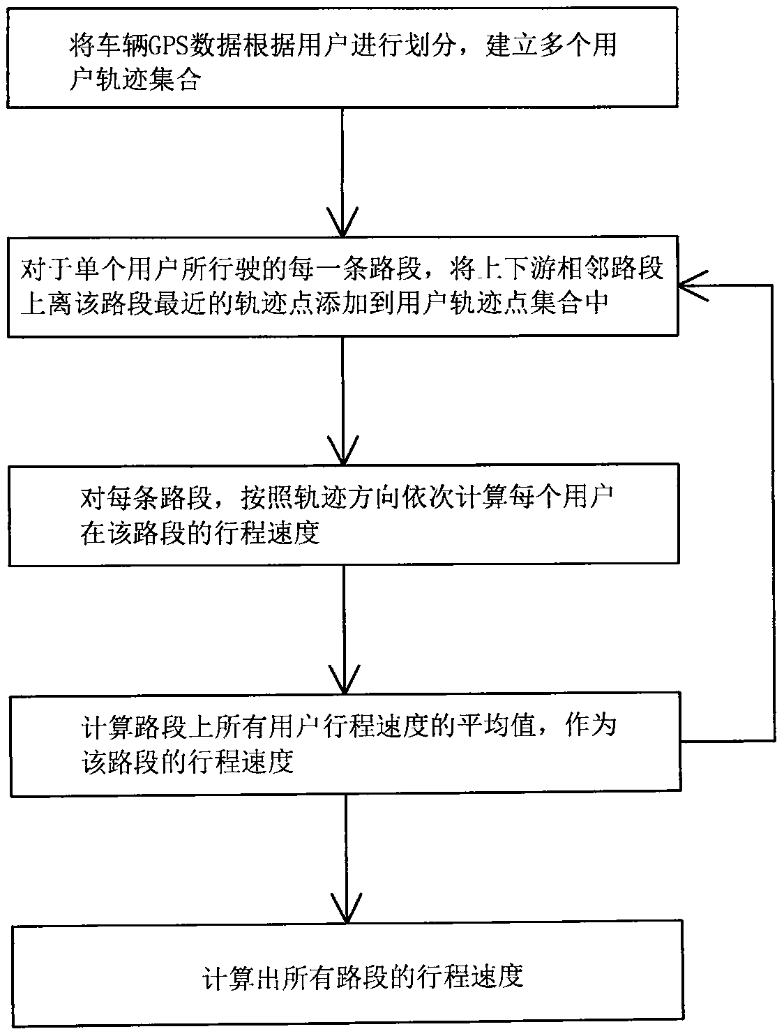
[0051] This embodiment is a method for calculating road section travel speed based on sparse GPS data. In order to verify the proposed calculation method, in this embodiment, the trajectory data of five taxi users are selected as the research object for experiment. The road sections that these five users drive are partly consistent, and the track point data is divided into three categories: more, general and sparse, which are representative. In this embodiment, 5 min is used as the calculation interval. Such as figure 1 As shown, including the following steps:

[0052] S1. Divide the vehicle GPS data according to users and establish a collection of multiple user track points;

[0053] The specific process includes the following steps:

[0054] S11. In a time slice, match the vehicle GPS data according to the road section; read the GPS data of the taxi within 5 minutes from the database. The basic GPS data information includes the user number, track point time, and track point loca...


PUM


Abstract

The invention relates to a road segment travel speed calculation method based on sparse GPS data, and solves the problems that the present road segment travel speed calculation depends on the number of traffic floating vehicles and calculation is inaccurate when the GPS data are sparse. The method comprises the following steps: dividing the vehicle GPS data according to the user to establish usertrajectory point set; as for each road segment traveled by a single user, the trajectory points closest to the road segment on the upstream and downstream adjacent road segments are added to the usertrajectory point set; as for each road segment, the travel speed of each user on the road segment is sequentially calculated according to the trajectory direction; and calculating the average travel speed of all the users on the road segment as the travel speed of the road segment and calculating the travel speed of all the road segments. Serious dependence on the number of the traffic floating vehicles in the average speed obtaining method for the common road segment can be overcome so as to improve the accuracy of road segment travel speed calculation; and calculation is simple and convenient, the calculation speed is high and the reliability is high.

Description

Technical field [0001] The present invention relates to the research field of intelligent transportation systems, and in particular to a method for calculating road section travel speed based on sparse GPS data that reduces estimation errors. Background technique [0002] Intelligent transportation systems have been successfully applied in many fields such as traffic management, travel guidance, signal control, and safe driving. The estimation of the average travel time of road sections is one of the important theoretical issues of intelligent transportation systems. GPS (Global Positioning System) floating car information collection technology, as a new dynamic collection technology of traffic status information, has many advantages such as all-weather, strong real-time, low detection cost, high data accuracy, and wide collection range, and it is available worldwide Active research and promotion and application. [0003] Related research work includes: Models for estimating the ...

Claims


Application Information

Patent Timeline
Patent Type & Authority Applications(China)
IPC IPC(8): G08G1/01G08G1/052
CPCG08G1/0112G08G1/052
Inventor 夏莹杰蒋萌青单振宇
Owner HANGZHOU YUANTIAO TECH CO LTD
Why Eureka
Try Eureka