On-board LiDAR point cloud road information extraction method and device

A technology of road information and extraction method, which is applied in the field of airborne LiDAR point cloud road information extraction, can solve the problems of reducing calculation time, low efficiency, and ineffective production and application, and achieves rapid extraction and reduction of calculation time. Effect

Pending Publication Date: 2018-11-30
国网电力空间技术有限公司 +1
View PDF2 Cites 18 Cited by
  • Summary
  • Abstract
  • Description
  • Claims
  • Application Information

AI Technical Summary

Problems solved by technology

[0005] The embodiment of the present invention provides an airborne LiDAR point cloud road information extraction method and device, using reflection intensity information for extraction, and using filtering to eliminate interference from non-ground points, reducing c

Method used


Image

  • On-board LiDAR point cloud road information extraction method and device
  • On-board LiDAR point cloud road information extraction method and device
  • On-board LiDAR point cloud road information extraction method and device

Examples


Embodiment Construction

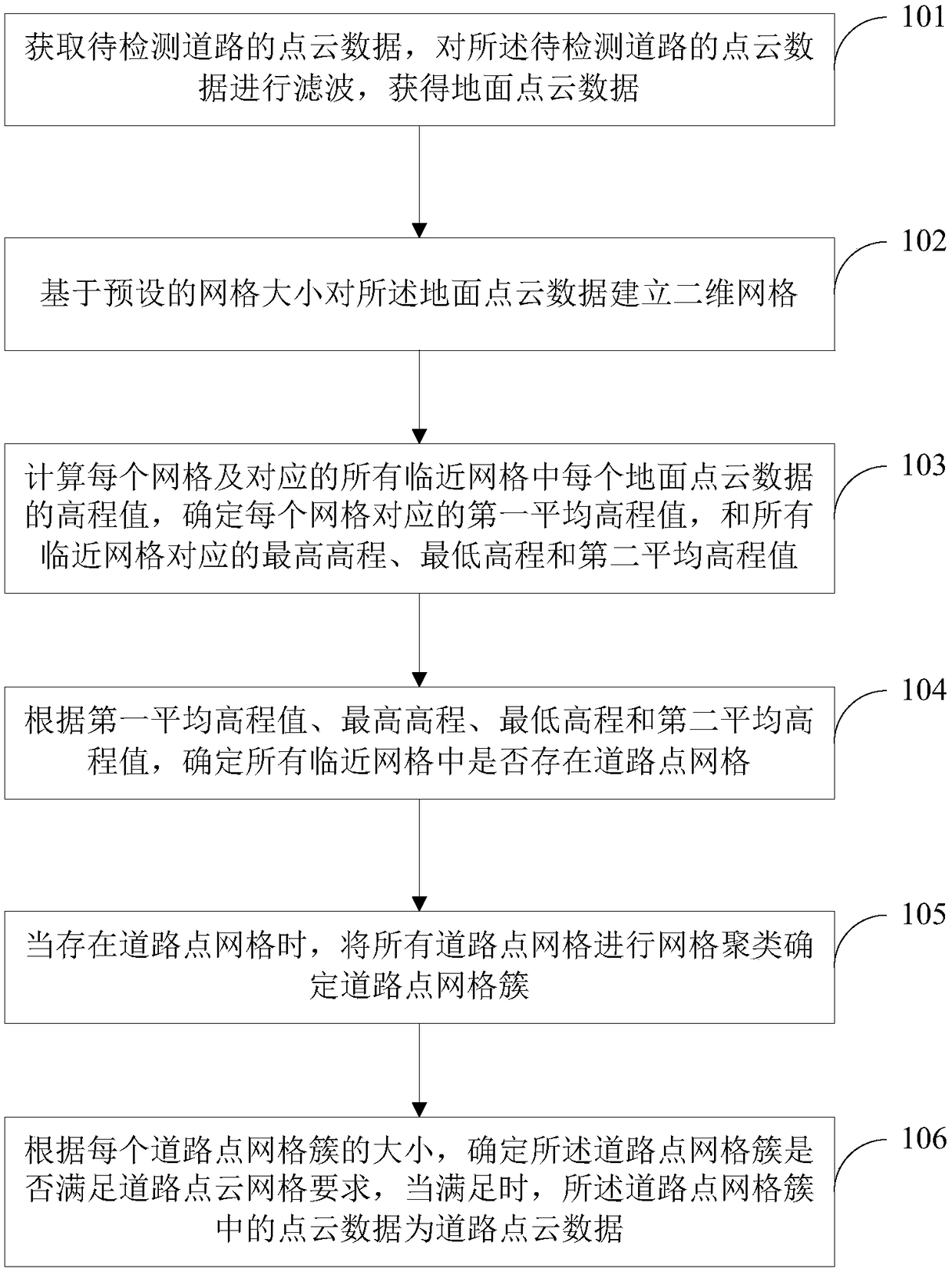
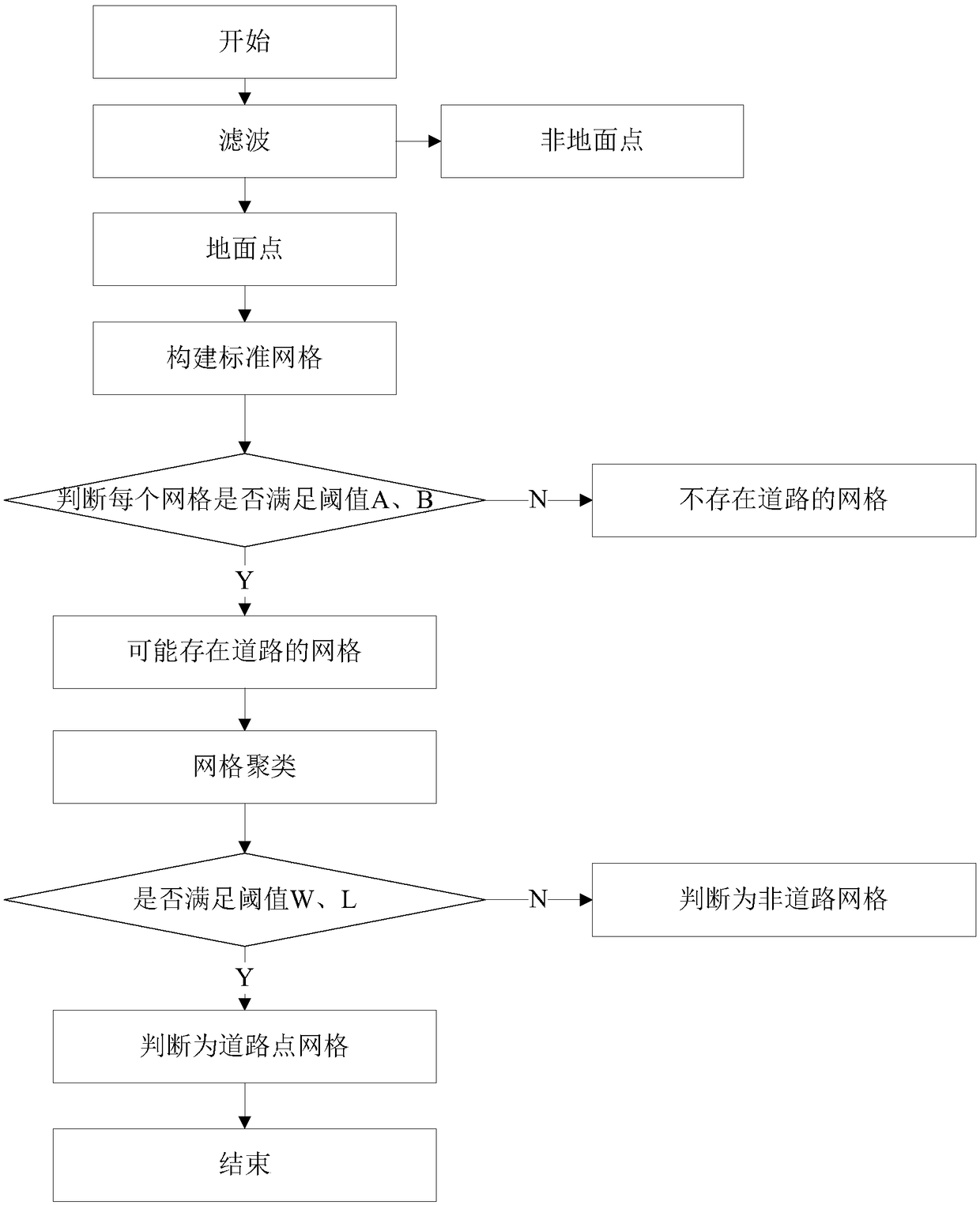
[0028] The following will clearly and completely describe the technical solutions in the embodiments of the present invention with reference to the accompanying drawings in the embodiments of the present invention. Obviously, the described embodiments are only some of the embodiments of the present invention, not all of them. Based on the embodiments of the present invention, all other embodiments obtained by persons of ordinary skill in the art without making creative efforts belong to the protection scope of the present invention.

[0029] In an embodiment of the present invention, an airborne LiDAR point cloud road information extraction method is provided, such as figure 1 As shown, the airborne LiDAR point cloud road information extraction method includes:

[0030] Step 101: Obtain point cloud data of the road to be detected, filter the point cloud data of the road to be detected, and obtain ground point cloud data;

[0031] Step 102: Establish a two-dimensional grid for...


PUM


Abstract

The invention provides an on-board LiDAR point cloud road information extraction method and device. The method comprises the following steps that point cloud data of a to-be-detected road is filteredto obtain ground point cloud data; a two-dimensional net is established for ground point cloud data; first average elevation value for each grid, a highest elevation, a lowest elevation for and secondaverage elevation value of all adjacent grids are determined, existence of road point grids in all the adjacent grids is determined according to values; when the road point grids exist, grid clustering is carried out for all road point grids to determine road point grid clusters; and according to the size of each road point grid cluster, whether the point cloud data in the road point grid clusterare road point cloud data is determined. According to the technical scheme, a standard spatial grid is established for the point cloud, location of the road is determined by the spatial distributioncharacteristics and the relationship between elevation differences; and the grids with roads are determined according to the grid cluster growth mode to achieve the aim of road extraction.

Description

technical field [0001] The invention relates to the technical field of laser point cloud classification, in particular to an airborne LiDAR point cloud road information extraction method and device. Background technique [0002] Airborne Lidar (LIDAR) technology is a technology developed in recent years that can directly obtain 3D information on the ground. It has incomparable advantages over traditional aerial photogrammetry and has been widely used in urban building extraction and 3D reconstruction. However, the point cloud data obtained by LIDAR contains not only building information, but also other non-building information, such as ground information, vegetation information, and road information. It is usually difficult to segment roads and surrounding ground points using height information, which makes the automatic extraction of road information more difficult than that of buildings. There are relatively few research results, and road information is getting more and mo...

Claims


Application Information

Patent Timeline
IPC IPC(8): G01S17/42G01S17/89G01S7/48G01S7/487
CPCG01S7/4802G01S7/4873G01S17/42G01S17/89
Inventor 王和平邹彪刘宁程海涛胡伟姜文东杨国柱王佳颖刘成强高申坤
Owner 国网电力空间技术有限公司
Why Eureka
Try Eureka