
High-resolution satellite image super-resolution reconstruction method

A satellite image, high-resolution technology, applied in image data processing, graphics and image conversion, instruments, etc., can solve the problems of inability to make full use of complementary information of multi-frame images, artificial processing errors, undersampling and noise, etc., to achieve detail enhancement The effect is obvious, the overall image quality is improved, and the effect of maintaining a high peak signal-to-noise ratio

Inactive Publication Date: 2018-12-07
CHANGGUANG SATELLITE TECH CO LTD
View PDF5 Cites 7 Cited by
  • Summary
  • Abstract
  • Description
  • Claims
  • Application Information

AI Technical Summary

Problems solved by technology

[0006] The present invention provides a high-resolution satellite image in order to solve the existing problems of image blurring, distortion, under-sampling, noise, etc. in the existing image reconstruction method, and in addition, there are artificial processing errors and the complementary information between multiple frames of images cannot be fully utilized. super-resolution reconstruction method

Method used


Image

  • High-resolution satellite image super-resolution reconstruction method
  • High-resolution satellite image super-resolution reconstruction method
  • High-resolution satellite image super-resolution reconstruction method

Examples


specific Embodiment approach 1

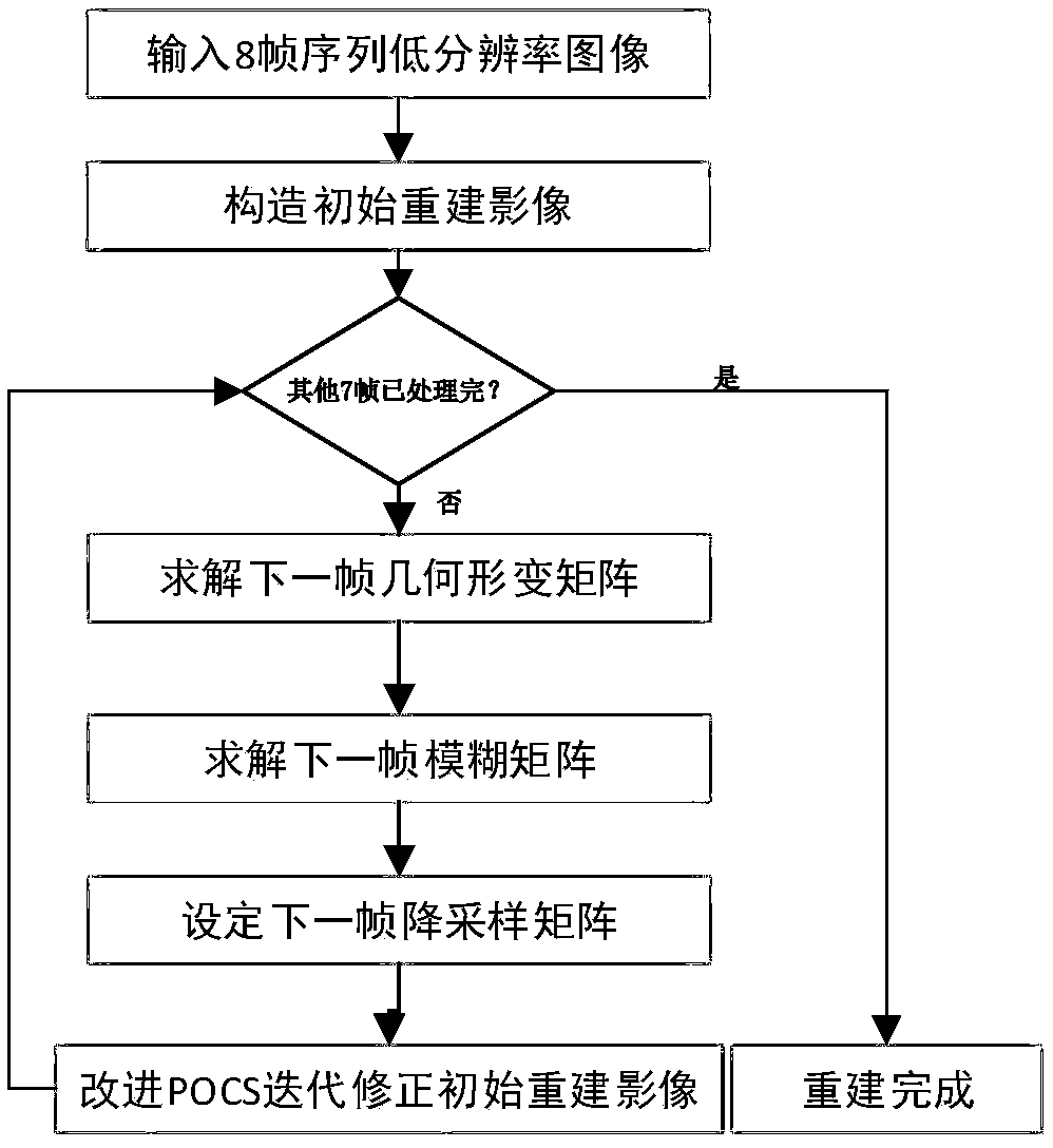
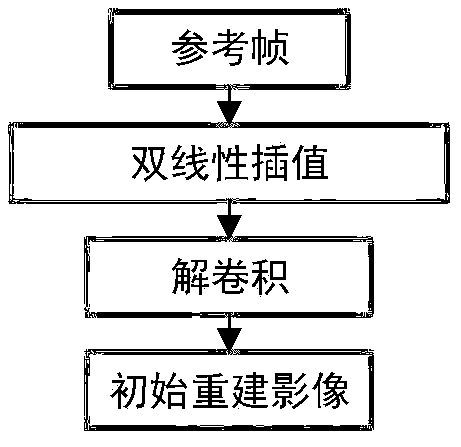
[0026] Specific implementation mode 1. Combination Figure 1 to Figure 9 Describe this embodiment, the high-resolution satellite image super-resolution reconstruction method, the method first combines the bilinear interpolation and deconvolution method to construct the initial reconstruction image, and then calculates the relative The geometric deformation matrix of the first frame fuzzy matrix B k , the downsampling matrix D. Then, using the improved POCS super-resolution reconstruction method, the residual calculation formula, residual constraint set, point projection operator, etc. are designed, and the initial reconstruction image is iteratively corrected according to the formula.

[0027] The specific process is:

[0028] Step 1. Input 8 frames of low-resolution images, and construct an initial reconstructed image for the first frame of the images;

[0029] Step 2, using the active viewpoint image degradation analysis model to calculate the fuzzy matrix of other fram...


PUM


Abstract

A high-resolution satellite image super-resolution reconstruction method relates to the technical field of high-resolution image processing, solves the problems of image blurring, distortion, under-sampling, noise, etc. in existing image reconstruction methods, and, moreover, solves the problems that artificial processing errors exist and complementary information between multi-frame images cannotbe fully used in the existing image reconstruction methods. The high-resolution satellite image super-resolution reconstruction method comprises the following steps: inputting 8 frames of sequence low-resolution images, and building an initial reconstruction image for the first frame of the images; calculating a fuzzy matrix of other frames and a geometric deformation matrix of the other frames relative to the first frame using an active viewpoint image degradation analysis model, and determining a down-sampling matrix according to the magnification ratio of the initial reconstruction image relative to the first frame; designing a residual error calculation formula, a residual error constraint set and a point projection operator using an improved POCS super-resolution reconstruction method, and performing iterative correction on the initial reconstruction image. Image detail information is significantly improved, and the comprehensive quality of the image is greatly improved.

Description

technical field [0001] The invention relates to the technical field of high-resolution image processing, in particular to a method for super-resolution reconstruction of high-resolution satellite images. Background technique [0002] Satellite image super-resolution reconstruction technology refers to an image processing technology that uses a computer to process a low-resolution push-broom image or video image sequence to restore a high-resolution image. The high-resolution image has a high pixel density and can Provide more details, which often play a key role in subsequent application development, such as object recognition. [0003] In a large number of image applications, people often expect high-resolution images. High-resolution images mean that the image has a high pixel density and can provide more details. These details are indispensable in many applications, and are also important for remote sensing images. Thus, for example, using high-resolution satellite image...

Claims


Application Information

Patent Timeline
Patent Type & Authority Applications(China)
IPC IPC(8): G06T3/40
CPCG06T3/4023G06T3/4076
Inventor 高放张鹏安源钟兴朱瑞飞李竺强翟雨微王春月
Owner CHANGGUANG SATELLITE TECH CO LTD
Learn More