
A mangrove extraction method and system for water and land regions in remote sensing images

A technology of remote sensing images and extraction methods, applied in the field of remote sensing, can solve the problem of inability to accurately extract the spatial information of mangroves, and achieve the effect of improving the accuracy

Active Publication Date: 2018-12-18
NORTHEAST INST OF GEOGRAPHY & AGRIECOLOGY C A S
View PDF4 Cites 9 Cited by
  • Summary
  • Abstract
  • Description
  • Claims
  • Application Information

AI Technical Summary

Problems solved by technology

[0003] Traditional mangrove spatial extraction methods only use spectral information, and only consider the information of mangroves outside the water body area when extracting mangroves, which cannot accurately extract the spatial information of mangroves

Method used


Image

  • A mangrove extraction method and system for water and land regions in remote sensing images
  • A mangrove extraction method and system for water and land regions in remote sensing images

Examples


Embodiment Construction

[0056] The following will clearly and completely describe the technical solutions in the embodiments of the present invention with reference to the accompanying drawings in the embodiments of the present invention. Obviously, the described embodiments are only some, not all, embodiments of the present invention. Based on the embodiments of the present invention, all other embodiments obtained by persons of ordinary skill in the art without making creative efforts belong to the protection scope of the present invention.

[0057] The purpose of the present invention is to provide a method and system for extracting mangrove forests in water and land areas in remote sensing images, so as to improve the accuracy of mangrove spatial extraction.

[0058] In order to make the above objects, features and advantages of the present invention more comprehensible, the present invention will be further described in detail below in conjunction with the accompanying drawings and specific embod...


PUM


Abstract

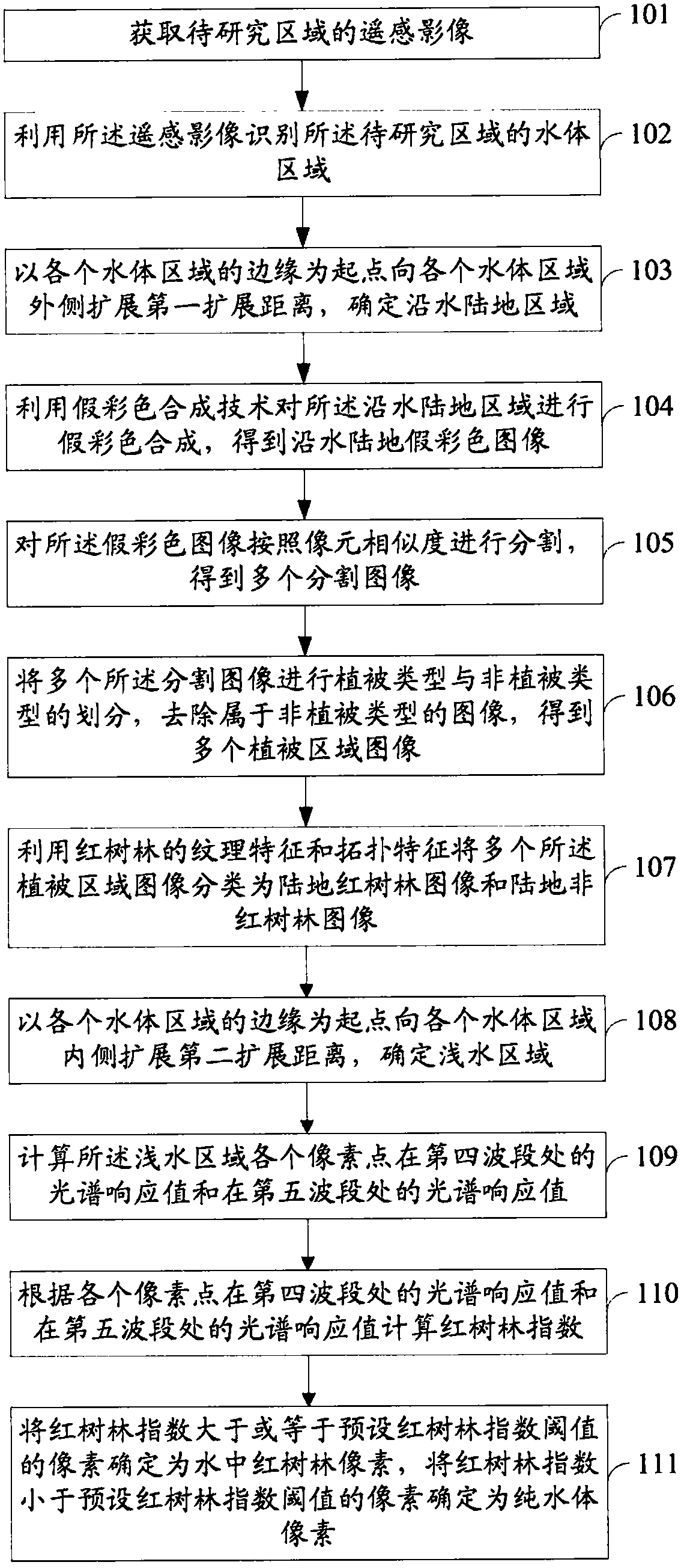
The invention discloses a mangrove extracting method and system in water and land regions of a remote sensing image. The method comprises the following steps of: acquiring remote sensing images of anarea to be studied; using remote sensing images to identify the water area of the area to be studied; using pseudocolor synthesis and image segmentation techniques to process the image outside the water body region to obtain multiple segmented images; removing images belonging to non-vegetation types from the segmented images to obtain multiple vegetation region images; using the NDVI arithmetic features, LSWI arithmetic features, texture features and topological features of the mangrove, classifying a plurality of the vegetation region images into a land mangrove image and a land non-mangroveimage. At the inner side of the water body region, the mangrove index is calculated by using the spectral response values of the pixel points at the fourth wave band and the spectral response valuesat the fifth wave band, and the mangrove pixels in the water are determined by comparing the calculated mangrove index values with the mangrove index threshold values. The method and the system of theinvention can improve the accuracy of mangrove spatial extraction.

Description

technical field [0001] The invention relates to the technical field of remote sensing, in particular to a method and system for extracting mangroves in water and land areas in remote sensing images. Background technique [0002] Mangrove refers to the tidal flat wetland woody biome composed of evergreen shrubs or trees that grow in the upper part of the tropical and subtropical low-energy coastal intertidal zone and are flooded by periodic tides. Composed species include herbs, vines and mangroves. Mangroves grow in tidal flats and shoals at the junction of the land and the ocean, and are a special ecosystem where the land transitions to the ocean. Because mangroves have the functions of protecting against wind and berms, stabilizing coastlines, and purifying water quality, studying the distribution of mangroves is of great significance for effectively strengthening the protection and management of mangrove wetlands and ecological restoration. [0003] Traditional mangrove...

Claims


Application Information

Patent Timeline
IPC IPC(8): G06K9/00
CPCG06V20/188
Inventor 王宗明贾明明毛德华任春颖何兴元
Owner NORTHEAST INST OF GEOGRAPHY & AGRIECOLOGY C A S
Learn More