Feature-oriented high-precision gravity map construction and interpolation method

An interpolation method and gravity map technology, which are applied in the measurement of gravitational fields, instruments, measurement devices, etc., can solve the problems of limited data coverage, insufficient efficiency and capability, and high measurement costs, reducing the workload of shipborne measurement and designing scientific Reasonable and high-precision effect

Active Publication Date: 2018-12-25
TIANJIN NAVIGATION INSTR RES INST
View PDF7 Cites 5 Cited by
  • Summary
  • Abstract
  • Description
  • Claims
  • Application Information

AI Technical Summary

Problems solved by technology

Shipborne marine gravity measurement has the characteristics of high precision and high resolution, but there are the following problems: first, the measurement cost is high, the cycle is long, and the data coverage is limited; second, the current shipborne gravity measurement is equidistant along the longitude Layout the survey line in the direction, and configure the test line in the vertical direction of the survey line according to a certain proportion, such as figure 1 As shown, the survey line layout has nothing to do with the characteristic distribution of the gravity field, and its efficiency and ability are insufficient in reflecting the characteristics of the gravity field

Method used


Image

  • Feature-oriented high-precision gravity map construction and interpolation method
  • Feature-oriented high-precision gravity map construction and interpolation method
  • Feature-oriented high-precision gravity map construction and interpolation method

Examples


Embodiment Construction

[0067] Embodiments of the present invention are described in further detail below in conjunction with the accompanying drawings:

[0068] A feature-oriented high-precision gravity map construction and interpolation method, including the following steps:

[0069] Step 1. Construct a high-precision gravity map containing accurate feature information according to the characteristic distribution characteristics of the gravity field;

[0070] The concrete steps of described step 1 include:

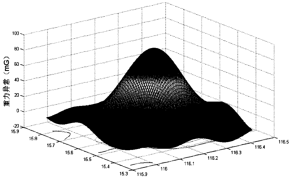
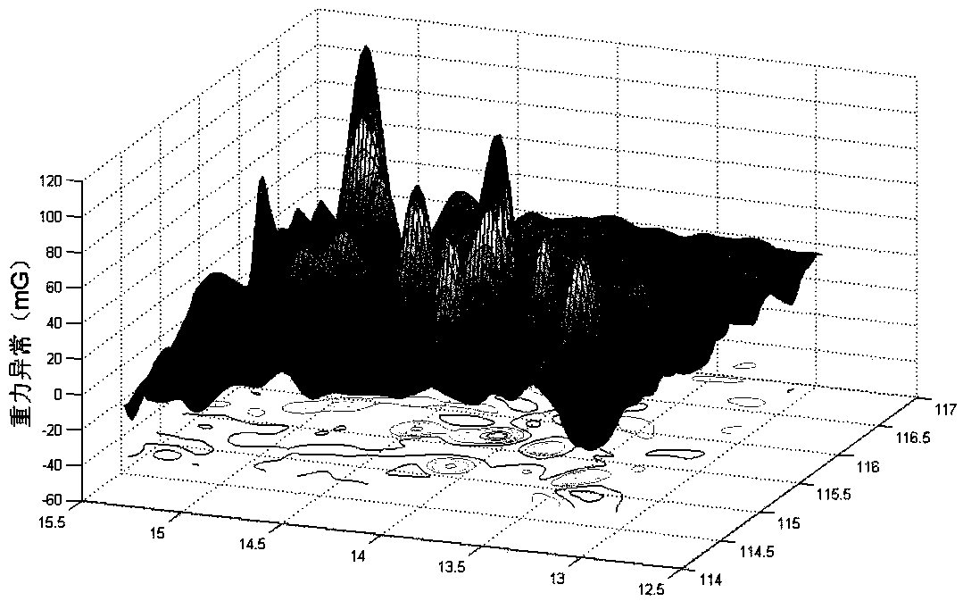
[0071] (1) Based on the gravity map information obtained by satellite altimetry or other means, preliminarily determine the peak point of the regional gravity anomaly, denoted as O’(Lono1, Lato1).

[0072] (2) Based on the gravity map information obtained by satellite altimetry or other means, start from the O' point and extend to the surroundings, search and determine the fastest descending direction n1, the second fastest descending direction n2, and the fastest descending direction The slo...


PUM


Abstract

The invention relates to a feature-oriented high-precision gravity map construction and interpolation method, which is characterized by comprising the following steps of: step 1, constructing a high-precision gravity map containing accurate feature information according to distribution characteristics of a gravity field feature; and step 2, calculating a gravity abnormal value at any point P(r

,theta

) in a region by using a multiple linear interpolation method or a radial gravity abnormal nonlinear feature equivalent method according to the high-precision gravity map constructed in the step 1. The feature-oriented high-precision gravity map construction and interpolation method adopts a direct description manner of the gravity field feature, which comprises a region gravity abnormalpeak point and nonlinear information falling along the radial gravity anomaly from the peak point, so that the description of the gravity field feature is more efficient and accurate, meanwhile, the shipborne measurement workload of constructing the gravity map is reduced, and the demand of the gravity field feature positioning technology on gravity field feature information is met.

Description

technical field [0001] The invention belongs to the technical field of geophysical field navigation and positioning, and relates to the application of earth gravity field information resources in autonomous navigation and positioning technology, in particular to a feature-oriented high-precision gravity map construction and interpolation method. Background technique [0002] The earth's gravity field is a physical field that reflects the distribution characteristics of the earth's matter. The difference between the actual gravity field and the normal gravity field is called the disturbance gravity field. The disturbance gravity field includes parameters such as gravity anomaly and vertical deviation. Gravity field information has long-term stability and unique spatial distribution characteristics, and is closely related to the local geographic location, providing a natural reference for navigation. The gravity field information positioning technology utilizes the correlation...

Claims


Application Information

Patent Timeline
Patent Type & Authority Applications(China)
IPC IPC(8): G01V7/06
CPCG01V7/06
Inventor 李晓平刘俊王毅张正雅吴太旗
Owner TIANJIN NAVIGATION INSTR RES INST
Why Eureka
Try Eureka