Urban land function identification and change detection method

A technology for urban function and change detection, applied in the field of big data analysis, can solve problems such as uncertainty of analysis results, insufficient recognition ability of mixed function areas, and difficulty in guaranteeing the integrity of POI data sources, etc.

Active Publication Date: 2019-02-12
CENT SOUTH UNIV
View PDF2 Cites 51 Cited by
  • Summary
  • Abstract
  • Description
  • Claims
  • Application Information

AI Technical Summary

Problems solved by technology

[0009] ① Existing methods mostly rely on a single data source to identify urban functional areas. For example, although urban functional identification methods based on remote sensing images can extract urban functional structures (such as built-up areas, water areas, agricultural land, etc.) Lack of fine-scale identification of urban functional areas; urban functional area identification methods based on POI data can reflect the distribution of urban functional areas on a fine scale, but because the integrity of POI data sources is difficult to guarantee, in areas where POI data is sparse, It is difficult to accurately estimate the land use function with this method, and the analysis results have great uncertainty
[0010] ② Existing methods are mainly

Method used


Image

  • Urban land function identification and change detection method
  • Urban land function identification and change detection method
  • Urban land function identification and change detection method

Examples


Embodiment Construction

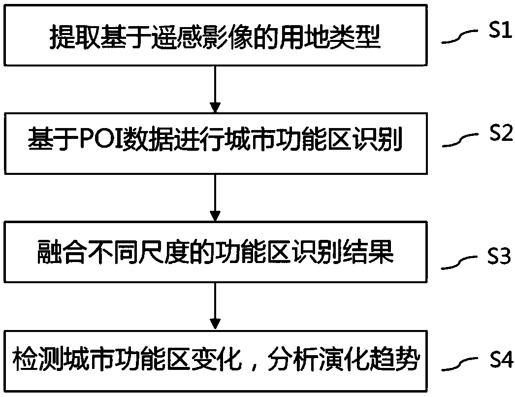
[0061] The specific implementation manners of the present invention will be further described below in conjunction with the drawings and examples. The following examples are only used to illustrate the technical solution of the present invention more clearly, but not to limit the protection scope of the present invention.

[0062] Such as figure 1 As shown, the present invention provides a function recognition and change detection method of urban functional land that integrates remote sensing images and POI data, uses the spectrum and texture features of remote sensing images to identify different types of land use in urban areas, and then combines urban road network data, POI data realizes further fine division and identification of urban land use functions. The specific method steps are as follows:

[0063] S1. Extracting land use types based on remote sensing images.

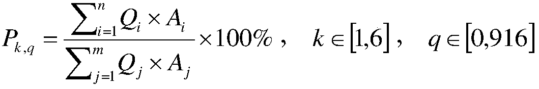
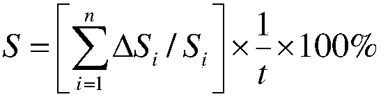
[0064] 1) According to the requirements of urban planning norms, carry out basic classification of land ...


PUM


Abstract

The invention discloses an urban land function identification and change detection method fusing remote sensing image and POI data. The method comprises the following steps of: extracting the land type based on a remote sensing image; identifying an urban functional areas based on the POI Data; fusing different scales of functional region recognition results; detecting the changes of the urban functional areas and analyzing the evolutionary trend. The method of the invention comprehensively considers the characteristics of the data from different sources, identifies the urban functional areasat different scales by fusing remote sensing images and the POI data, fuses the identification results, and realizes the accurate identification of the urban functional areas; and fully considers thePOI area weight, so that the mixed functional areas can be effectively identified. And through the multi-time series data, an evolution analysis model of the urban functional area is established, andthe spatial and temporal change law and trend of the urban land functions are excavated.

Description

technical field [0001] The invention belongs to the field of big data analysis, and in particular relates to a method for urban land function identification and change detection by fusing remote sensing images and POI data. Background technique [0002] Urban land use and functional zoning (i.e., urban functional area) is a geographical unit composed of functionally similar elements in urban space. Identifying urban functional areas helps to better understand the spatial structure of a city, lays the foundation for analyzing the differences between urban development and urban planning in reality, and clarifying the direction of reasonable planning. The change of urban functional areas is a realistic response to human activities in the city. Looking back at the degree and scale of human activities through the changes of functional areas plays an important auxiliary role in further research on the development law of human activities and guiding the rational development of land...

Claims


Application Information

Patent Timeline
IPC IPC(8): G06F16/29G06F16/9537G06K9/00G06Q10/06G06Q50/26
CPCG06Q10/0639G06Q50/26G06V20/13
Inventor 刘慧敏徐一源唐建波邓敏石岩陈杰
Owner CENT SOUTH UNIV
Why Eureka
Try Eureka