Method, apparatus, computer device and storage medium for commercial site selection

A commercial and preset value technology, applied in business, computing, instruments, etc., can solve problems such as inaccurate forecast results, forecast parameters and weight settings, and achieve the effect of reducing computing costs and improving efficiency and accuracy

Active Publication Date: 2019-02-15
深圳市和讯华谷信息技术有限公司
4 Cites 13 Cited by

AI-Extracted Technical Summary

Problems solved by technology

[0006] Embodiments of the present invention provide a method, device, computer equipment, and storage medium for commercial location selection, aiming to solve the problem of ...

Method used

[0040] In the present embodiment, it is necessary to utilize the mature geohash algorithm to carry out urban gridding. Divide the entire Beijing map into several grids of standard size. The plots circled by the user can fall into one of the grids, and then other similar grids are recommended to the user through the algorithm of the present invention. Geohash is a mature address encoding method, which can encode two-dimensional spatial longitude and latitude data into a string. The basic principle is to understand the earth as a two-dimensional pla...

Abstract

The invention discloses a method, a device, a computer device and a storage medium for commercial site selection. The method comprises the following steps: a computer receives an area selected on a city map input by a user; Dividing the city into a plurality of grids, extracting big data of the portrait within a set time, carrying out mesh portrait on each grid by using the big data, and guiding auser to input a weight value of a mesh label of the mesh portrait; Converting the mesh images into mesh pictures by using a digital image processing technique; taking The image similarity algorithm to find other grids whose approximation degree between the region selected by the user and the mesh picture exceeds the preset value, and taking the image similarity algorithm to find other grids whoseapproximation degree exceeds the preset value. The method, the device, the computer device and the storage medium for commercial site selection can independently select features and weights of features according to backgrounds of different industries, and display the mesh with high approximation degree to the user in the form of images. The method is simple and intuitive, and improves the efficiency and accuracy of site selection prediction.

Application Domain

Technology Topic

Image

  • Method, apparatus, computer device and storage medium for commercial site selection
  • Method, apparatus, computer device and storage medium for commercial site selection
  • Method, apparatus, computer device and storage medium for commercial site selection

Examples

  • Experimental program(1)

Example Embodiment

[0032] The following will clearly and completely describe the technical solutions in the embodiments of the present invention with reference to the accompanying drawings in the embodiments of the present invention. Obviously, the described embodiments are some of the embodiments of the present invention, but not all of them. Based on the embodiments of the present invention, all other embodiments obtained by persons of ordinary skill in the art without making creative efforts belong to the protection scope of the present invention.
[0033] It should be understood that when used in this specification and the appended claims, the terms "comprising" and "comprises" indicate the presence of described features, integers, steps, operations, elements and/or components, but do not exclude one or Presence or addition of multiple other features, integers, steps, operations, elements, components and/or collections thereof.
[0034] It should also be understood that the terminology used in the description of the present invention is for the purpose of describing particular embodiments only and is not intended to be limiting of the present invention. As used in this specification and the appended claims, the singular forms "a", "an" and "the" are intended to include plural referents unless the context clearly dictates otherwise.
[0035] It should also be further understood that the term "and/or" used in the description of the present invention and the appended claims refers to any combination and all possible combinations of one or more of the associated listed items, and includes these combinations .
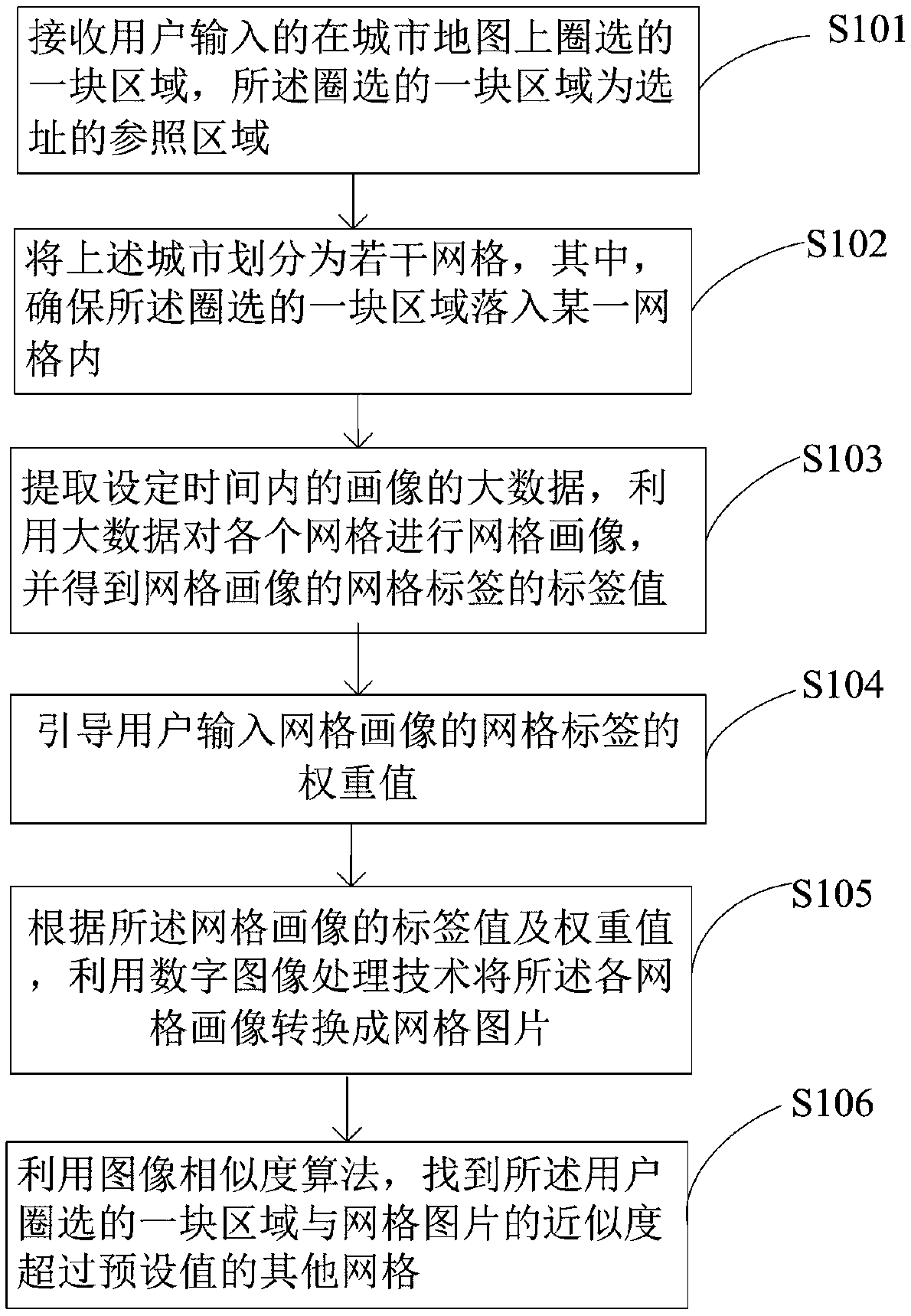
[0036] Please refer to the attached figure 1 , with figure 1 It is a flow chart of a method for selecting a commercial location provided by an embodiment of the present invention, and the method for selecting a commercial location includes the following steps:
[0037] Step S101, the computer receives a circled area on the city map input by the user, and the circled area is a reference area for site selection.
[0038] For example: the urban grid similarity algorithm based on digital image recognition technology, relying on the big data platform, images the data with grid attributes, and accurately and efficiently calculates the similarity relationship between grids through image recognition technology. The application scenario of the embodiment of the present invention is that the user circles a plot in the Beijing Guomao area on the electronic map of the computer terminal, and the purpose is to find several other similar plots in the Beijing area for commercial activities. The specified area is the reference area.
[0039] Step S102. Divide the above-mentioned city into several grids, and ensure that the circled area falls into a certain grid.
[0040] In this embodiment, the mature geohash algorithm needs to be used for urban gridding. Divide the entire Beijing map into several grids of standard size. The plots circled by the user can fall into one of the grids, and then other similar grids are recommended to the user through the algorithm of the present invention. Geohash is a mature address encoding method, which can encode two-dimensional spatial longitude and latitude data into a string. The basic principle is to understand the earth as a two-dimensional plane, recursively decompose the plane into smaller sub-blocks, each sub-block has the same code within a certain range of latitude and longitude, this method is simple and easy to use, and can meet the needs of small-scale The data is retrieved by latitude and longitude. It can be found that when the six-digit geohash is used for grid division, the plot circled by the user just falls in the grid with ID WX4g41. Therefore, the entire Beijing map is divided into grids by six-digit geohash, and the size of the six-digit geohash grid is about 1.2Km*0.6Km.
[0041] Step S103 , extract big data of the portrait within a set time, use the big data to make a grid portrait of each grid, and obtain the label value of the grid label of the grid portrait.
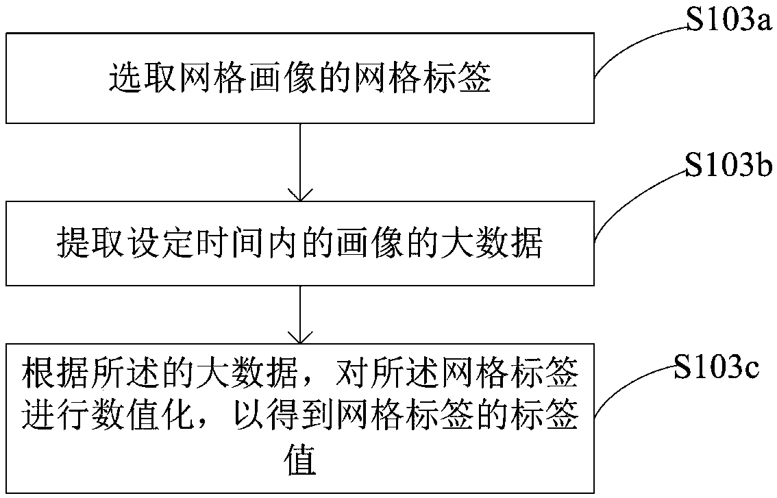
[0042] Among them, see figure 2 , figure 2 It is a sub-flow chart of the embodiment of the present invention, the step S103 of extracting the big data of the portrait within the set time, using the big data to make a grid portrait of each grid, and obtaining the grid label value of the grid portrait include:
[0043] Step S103a, selecting the grid label of the grid portrait;
[0044]Step S103b, extracting the big data of the portrait within the set time;
[0045] Step S103c, digitize the grid label according to the big data, so as to obtain the label value of the grid label.
[0046] Specifically: in order to make a 360-degree portrait of the grid divided in the previous step, it is necessary to fully mine the online and offline behavior of the crowd in the grid, the type of grid POI, and the number of visitors. Here are about 300 grid portrait tags, including the total number of resident population, total working population, gender ratio, age distribution of the overall population, education, consumption ability, income ability, consumer product level, values, and different types of POIs in the grid. The total number, the number of visitors, etc., make a multi-grained portrait of the grid. The minimum update period for each label is days. The grid labels are digitized and used as feature variables for the algorithm.
[0047] Step S104, guiding the user to input the weight value of the grid label of the grid portrait;
[0048] All the labels of the grid portrait will be used as feature variables to participate in the model algorithm, but for users in different industries, he focuses on different points, that is, different feature variables contribute differently to the site selection of different industries. The size of the contribution can be adjusted by setting the weight coefficient for the feature variable. For example, if the user chooses a location for a 4S store, then the characteristic variables that have nothing to do with it can be eliminated and will not participate in the calculation of the algorithm; some characteristic variables related to it also have different correlations. Here, the human-computer interaction method is used. Different weights (0.4, 0.3, 0.2, 0.1) are given to each characteristic variable by the user's choice of different degrees of attention (focus attention, attention, general attention, weak attention) to each feature variable.
[0049] Step S105, according to the label value and weight value of the grid portrait, using digital image processing technology to convert each grid portrait into a grid picture;
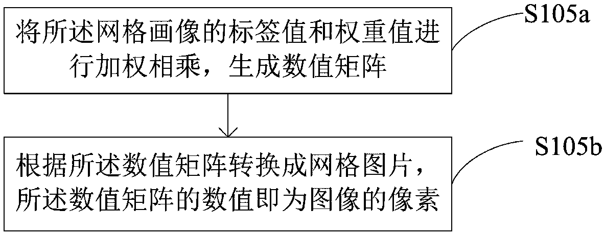
[0050] Among them, see image 3 , image 3 It is a sub-flowchart of this embodiment, and the step S105 of converting each grid image into a grid image using digital image processing technology according to the label value and weight value of the grid image includes:
[0051] Step S105a, performing weighted multiplication of the label value and weight value of the grid image to generate a numerical matrix;
[0052] Step S105b, converting into a grid image according to the numerical matrix, where the numerical values ​​of the numerical matrix are the pixels of the image.
[0053] Specifically: extract the portraits of each grid for a continuous period of time (this embodiment chooses half a year), and after digitization, filter valid labels as feature variables according to user needs, and multiply each feature variable by its respective weight to generate a new value matrix. Treat these processed values ​​as the pixels of the image, and use digital image processing technology to convert them into grid pictures with industry attributes. In this example, the feature image corresponding to the grid where the area circled by the user belongs.
[0054] Step S106 , using an image similarity algorithm to find other grids whose similarity between the area circled by the user and the grid picture exceeds a preset value.
[0055] Among them, see Figure 4 , Figure 4 It is a sub-flow chart of the embodiment of the present invention, and the step S106 of using the image similarity algorithm to find other grids whose similarity between the area circled by the user and the grid picture exceeds a preset value includes:
[0056] Step S106a, scaling the grid pictures so that all the grid pictures have the same size;
[0057] Step S106b, performing grayscale processing on the scaled grid image;
[0058] Step S106c, calculating the average value of pixels in each row of the grid picture to obtain the feature value of each row;
[0059] Step S106d, calculating the variance of the eigenvalues ​​of each row in the grid picture to obtain the eigenvalues ​​of the grid picture; and
[0060] Step S106e, comparing the feature value of the grid picture with the feature value of a circled area, and the grid picture whose approximation degree exceeds the preset value is the recommended location area.
[0061] Specifically: After converting all the grids in the Beijing area into the feature pictures shown in the above figure in the previous step, in this step we will use the picture WX4g41.jpg to perform similarity calculations with other pictures to find out the ones with high similarity picture.
[0062] Image scaling, all images involved in the calculation must be scaled to the same size, which is agreed to be 256*256 in this embodiment. The size of the zoomed image is determined by the amount of information and complexity of the original image. If the amount of information is small and the complexity is low, it needs to be scaled smaller. If the amount of information is large and the complexity is high, it cannot be zoomed too small, and important information is easily lost. . Therefore, it is necessary to flexibly define and scale the size according to specific needs, and maintain a balance between efficiency and accuracy.
[0063] Grayscale processing. Under normal circumstances, the calculation of image similarity has nothing to do with color. In order to ensure the efficiency of the algorithm, it is uniformly processed as a grayscale image to reduce the complexity of later calculations.
[0064] Calculate the average value. The average value here refers to calculating the average value of pixels in each row of the image. Thus each average represents the characteristics of the row.
[0065] Calculate the variance, calculate the variance of all the average values ​​in a picture, and the resulting variance is the feature value of the picture. The variance can well reflect the fluctuation of the pixel features of each row and record the main information of the picture.
[0066] Variance comparison, after the above calculation, each picture will generate a feature value (variance). The comparison of image similarity is to compare the closeness of image variance. The variance of a set of data can judge the stability of the array, and the closeness of the variance of multiple sets of data can reflect the closeness of the fluctuation of each set of data. Here we don't pay too much attention to the size of the variance, but only to the difference between the variances of the two pictures. The smaller the variance, the more similar the images are.
[0067] In another embodiment, another method of commercial site selection is also disclosed, which is the same as the method of site selection in the above-mentioned embodiment, the only difference is: the use of the image similarity algorithm to find the location selected by the user After the step S106 of other grids whose similarity between a region and the grid picture exceeds the preset value, it also includes:
[0068] Output other networks that exceed the preset value in order according to the degree of approximation;
[0069] According to the order of the degree of approximation, the color from dark to light is displayed on the map for the recommended site selection area.
[0070] For example: after obtaining the similarity between the grid selected by the user and the portrait features of all the grids in the Beijing area, output the top N grids and the similarity size (percentage system) according to the user's needs,
[0071] According to the specific geohash ID (that is, the picture name after removing .jpg), the specific grid position can be retrieved on the map. The similarity is the recommendation degree of the algorithm. Users can select the corresponding area according to their needs for the next step Business marketing and other activities. The figure below is the recommendation effect diagram of the front-end page of the algorithm of the present invention. The red rectangle is the reference area circled by the user, and the other blue rectangles are the areas recommended by the algorithm of the present invention. The color from dark to light represents the degree of recommendation from strong to weak , 1/2/3/4/5 are recommended rankings.
[0072] see Figure 5 , Figure 5 It is a schematic diagram of a commercial site selection device disclosed in an embodiment of the present invention. The commercial site selection device includes:
[0073] The receiving unit 101 receives an area circled on the city map input by the user, and the circled area is a reference area for site selection;
[0074] The grid division unit 102 divides the above-mentioned city into several grids, wherein it is ensured that the circled area falls into a certain grid;
[0075] The grid portrait unit 103 extracts the big data of the portrait within the set time, uses the big data to perform grid portraits on each grid, and obtains the tag value of the grid label of the grid portrait;
[0076] Wherein, in another embodiment, as in this embodiment, the grid image unit 103 includes:
[0077] Label unit 1031, used to select the grid label of the grid portrait;
[0078] Extraction unit 1032, used to extract the big data of the portrait within the set time;
[0079] The digitization unit 1033 is configured to digitize the grid label according to the big data, so as to obtain the label value of the grid label.
[0080] a guiding unit 104, guiding the user to input the weight value of the grid label of the grid portrait;
[0081] The grid image generation unit 105 converts each grid image into a grid image using digital image processing technology according to the label value and weight value of the grid image; and
[0082] The selection unit 106 uses an image similarity algorithm to find other grids whose similarity between the area circled by the user and the grid picture exceeds a preset value.
[0083] Wherein, in another embodiment, as in this embodiment, the selection unit 106 includes:
[0084] A scaling unit 1061, configured to scale the grid pictures so that all the grid pictures have the same size;
[0085] A grayscale processing unit 1062, configured to perform grayscale processing on the scaled grid image;
[0086] The average value calculation unit 1063 is used to calculate the average value of the pixel points of each row of the grid picture to obtain the feature value of each row;
[0087] Variance calculation unit 1064, used to calculate the variance of the feature value of each row in the grid picture to obtain the feature value of the grid picture; and
[0088] The comparison unit 1065 is configured to compare the feature value of the grid picture with the feature value of a circled area, and the grid picture whose approximation degree exceeds the preset value is the recommended location area.
[0089] see again Image 6 , Image 6 A computer device provided by an embodiment of the present invention, the computer device includes a memory and a processor, the memory stores a computer program, and the processor implements the above method for commercial site selection when executing the computer program.
[0090] The computer device is a terminal, where the terminal may be an electronic device with a communication function such as a smart phone, a tablet computer, a notebook computer, a desktop computer, a personal digital assistant, and a wearable device.
[0091] refer to Image 6 , the computer device 500 includes a processor 502 connected through a system bus 501 , a memory and a network interface 505 , where the memory may include a non-volatile storage medium 503 and an internal memory 504 .
[0092] The network interface 505 is used for network communication with other devices. Those skilled in the art can understand that, Image 6The structure shown in is only a block diagram of a part of the structure related to the solution of this application, and does not constitute a limitation to the computer device 500 on which the solution of this application is applied. The specific computer device 500 may include more than shown in the figure. More or fewer components, or combining certain components, or having a different arrangement of components.
[0093] The non-volatile storage medium 503 can store an operating system 5031 and a computer program 5032 . The computer program 5032 includes program instructions that, when executed, enable the processor 502 to execute a method for business location selection.
[0094] The processor 502 is used to provide calculation and control capabilities to support the operation of the entire computer device 500 .
[0095] The internal memory 504 provides an environment for the operation of the computer program 5032 in the non-volatile storage medium 503. When the computer program 5032 is executed by the processor 502, the processor 502 can be executed to perform the following steps: An area circled above, the area selected by the circle is the reference area for site selection; the above-mentioned city is divided into several grids, wherein, it is ensured that the area selected by the circle falls into a certain grid; the extraction design The big data of the portrait within a certain period of time, use the big data to make a grid portrait of each grid, and get the label value of the grid label of the grid portrait; guide the user to input the weight value of the grid label of the grid portrait; according to the The tag value and weight value of the grid portrait, using digital image processing technology to convert each grid portrait into a grid picture; and using the image similarity algorithm to find the area circled by the user and the grid picture Other meshes whose approximation exceeds the preset value.
[0096] The specific implementation process is as follows:
[0097] Please refer to the attached figure 1 , with figure 1 It is a flow chart of a method for selecting a commercial location provided by an embodiment of the present invention, and the method for selecting a commercial location includes the following steps:
[0098] Step S101, the computer receives a circled area on the city map input by the user, and the circled area is a reference area for site selection.
[0099] For example: the urban grid similarity algorithm based on digital image recognition technology, relying on the big data platform, images the data with grid attributes, and accurately and efficiently calculates the similarity relationship between grids through image recognition technology. The application scenario of the embodiment of the present invention is that the user circles a plot in the Beijing Guomao area on the electronic map of the computer terminal, and the purpose is to find several other similar plots in the Beijing area for commercial activities. The specified area is the reference area.
[0100] Step S102. Divide the above-mentioned city into several grids, and ensure that the circled area falls into a certain grid.
[0101] In this embodiment, the mature geohash algorithm needs to be used for urban gridding. Divide the entire Beijing map into several grids of standard size. The plots circled by the user can fall into one of the grids, and then other similar grids are recommended to the user through the algorithm of the present invention.
[0102] Step S103 , extract big data of the portrait within a set time, use the big data to make a grid portrait of each grid, and obtain the label value of the grid label of the grid portrait.
[0103] Among them, see figure 2 , figure 2 It is a sub-flow chart of the embodiment of the present invention, the step S103 of extracting the big data of the portrait within the set time, using the big data to make a grid portrait of each grid, and obtaining the grid label value of the grid portrait include:
[0104] Step S103a, selecting the grid label of the grid portrait;
[0105] Step S103b, extracting the big data of the portrait within the set time;
[0106] Step S103c, digitize the grid label according to the big data, so as to obtain the label value of the grid label.
[0107] Specifically: in order to make a 360-degree portrait of the grid divided in the previous step, it is necessary to fully mine the online and offline behavior of the crowd in the grid, the type of grid POI, and the number of visitors. Here are about 300 grid portrait tags, including the total number of resident population, total working population, gender ratio, age distribution of the overall population, education, consumption ability, income ability, consumer product level, values, and different types of POIs in the grid. The total number, the number of visitors, etc., make a multi-grained portrait of the grid. The minimum update period for each label is days. The grid labels are digitized and used as feature variables for the algorithm.
[0108] Step S104, guiding the user to input the weight value of the grid label of the grid portrait;
[0109] All the labels of the grid portrait will be used as feature variables to participate in the model algorithm, but for users in different industries, he focuses on different points, that is, different feature variables contribute differently to the site selection of different industries. The size of the contribution can be adjusted by setting the weight coefficient for the feature variable. Here, the human-computer interaction method is adopted, and different weights (0.4, 0.3, 0.2, 0.1) are given to each feature variable by the user's choice of different degrees of attention (focused attention, attention, general attention, and weak attention).
[0110] Step S105, according to the label value and weight value of the grid portrait, using digital image processing technology to convert each grid portrait into a grid picture;
[0111] Among them, see image 3 , image 3 It is a sub-flowchart of this embodiment, and the step S105 of converting each grid image into a grid image using digital image processing technology according to the label value and weight value of the grid image includes:
[0112] Step S105a, performing weighted multiplication of the label value and weight value of the grid image to generate a numerical matrix;
[0113] Step S105b, converting into a grid image according to the numerical matrix, where the numerical values ​​of the numerical matrix are the pixels of the image.
[0114] Step S106 , using an image similarity algorithm to find other grids whose similarity between the area circled by the user and the grid picture exceeds a preset value.
[0115] Among them, see Figure 4 , Figure 4 It is a sub-flow chart of the embodiment of the present invention, and the step S106 of using the image similarity algorithm to find other grids whose similarity between the area circled by the user and the grid picture exceeds a preset value includes:
[0116] Step S106a, scaling the grid pictures so that all the grid pictures have the same size;
[0117] Step S106b, performing grayscale processing on the scaled grid image;
[0118] Step S106c, calculating the average value of pixels in each row of the grid picture to obtain the feature value of each row;
[0119] Step S106d, calculating the variance of the eigenvalues ​​of each row in the grid picture to obtain the eigenvalues ​​of the grid picture; and
[0120] Step S106e, comparing the feature value of the grid picture with the feature value of a circled area, and the grid picture whose approximation degree exceeds the preset value is the recommended location area.
[0121] Specifically: After converting all the grids in the Beijing area into the feature pictures shown in the above figure in the previous step, in this step we will use the picture WX4g41.jpg to perform similarity calculations with other pictures to find out the ones with high similarity picture.
[0122] Image scaling, all images involved in the calculation must be scaled to the same size, which is agreed to be 256*256 in this embodiment. The size of the zoomed image is determined by the amount of information and complexity of the original image. If the amount of information is small and the complexity is low, it needs to be scaled smaller. If the amount of information is large and the complexity is high, it cannot be zoomed too small, and important information is easily lost. . Therefore, it is necessary to flexibly define and scale the size according to specific needs, and maintain a balance between efficiency and accuracy.
[0123] Grayscale processing. Under normal circumstances, the calculation of image similarity has nothing to do with color. In order to ensure the efficiency of the algorithm, it is uniformly processed as a grayscale image to reduce the complexity of later calculations.
[0124] Calculate the average value. The average value here refers to calculating the average value of pixels in each row of the image. Thus each average represents the characteristics of the row.
[0125] Calculate the variance, calculate the variance of all the average values ​​in a picture, and the resulting variance is the feature value of the picture. The variance can well reflect the fluctuation of the pixel features of each row and record the main information of the picture.
[0126] Variance comparison, after the above calculation, each picture will generate a feature value (variance). The comparison of image similarity is to compare the closeness of image variance. The variance of a set of data can judge the stability of the array, and the closeness of the variance of multiple sets of data can reflect the closeness of the fluctuation of each set of data. Here we don't pay too much attention to the size of the variance, but only to the difference between the variances of the two pictures. The smaller the variance, the more similar the images are.
[0127] In another embodiment, another method of commercial site selection is also disclosed, which is the same as the method of site selection in the above-mentioned embodiment, the only difference is: the use of the image similarity algorithm to find the location selected by the user After the step S106 of other grids whose similarity between a region and the grid picture exceeds the preset value, it also includes:
[0128] Output other networks that exceed the preset value in order according to the degree of approximation;
[0129] According to the order of the degree of approximation, the color from dark to light is displayed on the map for the recommended site selection area.
[0130] The method, device, computer equipment and storage medium of the commercial address selection in the embodiment of the present invention, the method includes: detecting the memory space value currently used by the browser; if the used memory space value exceeds the preset threshold value , then start to delete the historical cache data in the memory; and return to the step of detecting the value of the memory space used by the browser, when the browser starts, it starts to automatically repeatedly detect the memory, and when the memory exceeds the set threshold, delete the history Cache data to ensure sufficient memory space and avoid crashes or data loss.
[0131] Those of ordinary skill in the art can realize that the units and algorithm steps of the examples described in conjunction with the embodiments disclosed herein can be implemented by electronic hardware, computer software, or a combination of the two. In order to clearly illustrate the relationship between hardware and software Interchangeability. In the above description, the composition and steps of each example have been generally described according to their functions. Whether these functions are executed by hardware or software depends on the specific application and design constraints of the technical solution. Those skilled in the art may use different methods to implement the described functions for each specific application, but such implementation should not be regarded as exceeding the scope of the present invention.
[0132] In the several embodiments provided by the present invention, it should be understood that the disclosed devices and methods can be implemented in other ways. For example, the device embodiments described above are illustrative only. For example, the division of each unit is only a logical function division, and there may be another division method in actual implementation. For example, several units or components may be combined or integrated into another system, or some features may be omitted, or not implemented.
[0133]The steps in the methods of the embodiments of the present invention can be adjusted, combined and deleted according to actual needs. The units in the device of the embodiment of the present invention can be combined, divided and deleted according to actual needs. In addition, each functional unit in each embodiment of the present invention may be integrated into one processing unit, each unit may exist separately physically, or two or more units may be integrated into one unit.
[0134] If the integrated unit is realized in the form of a software function unit and sold or used as an independent product, it can be stored in a storage medium. Based on this understanding, the technical solution of the present invention is essentially or the part that contributes to the prior art, or all or part of the technical solution can be embodied in the form of software products, and the computer software products are stored in a storage medium In the above, several instructions are included to make a computer device (which may be a personal computer, a terminal, or a network device, etc.) execute all or part of the steps of the method described in each embodiment of the present invention.
[0135] The above content is only a preferred embodiment of the present invention, and is not intended to limit the implementation of the present invention. Those of ordinary skill in the art can easily make corresponding modifications or modifications according to the main concept and spirit of the present invention. Therefore, this The protection scope of the invention shall be determined by the protection scope required by the claims.

PUM

no PUM

Description & Claims & Application Information

We can also present the details of the Description, Claims and Application information to help users get a comprehensive understanding of the technical details of the patent, such as background art, summary of invention, brief description of drawings, description of embodiments, and other original content. On the other hand, users can also determine the specific scope of protection of the technology through the list of claims; as well as understand the changes in the life cycle of the technology with the presentation of the patent timeline. Login to view more.

Similar technology patents

Elevator balance coefficient detection device and method

InactiveCN105565101AReduce computing costEasy to carryElevatorsEngineeringGravitational acceleration
Owner:大连光程光电科技有限公司

Classification and recommendation of technical efficacy words

  • Reduce computing cost
  • Improve efficiency and accuracy

Orthogonal Source and Receiver Encoding

ActiveUS20130238246A1Reduce computing costDominate costGeometric CADSeismic data acquisitionSeismic surveyBandpass filtering
Owner:EXXONMOBIL UPSTREAM RES CO
Why Eureka
Try Eureka