Laser radar and visual sensor fused dynamic grid map structuring method

A visual sensor and laser radar technology, applied in the direction of re-radiation, instrumentation, electromagnetic wave re-radiation, etc., can solve the problems of lack of recognition and estimation of behavioral characteristics, and achieve the effect of enriching information

Inactive Publication Date: 2019-03-08
上海主线科技有限公司
View PDF0 Cites 54 Cited by
  • Summary
  • Abstract
  • Description
  • Claims
  • Application Information

AI Technical Summary

Problems solved by technology

[0003] The existing methods of using lidar to generate raster maps mainly focus on the construction of the drivable area, and lack the identification and behavioral characteristics estimation of traffic actors such as motor vehicles, bicycles, and pedestrians in the driving area.

Method used


Image

  • Laser radar and visual sensor fused dynamic grid map structuring method
  • Laser radar and visual sensor fused dynamic grid map structuring method
  • Laser radar and visual sensor fused dynamic grid map structuring method

Examples


Embodiment Construction

[0025] The specific implementation of the present invention will be described in detail below in conjunction with preferred embodiments.

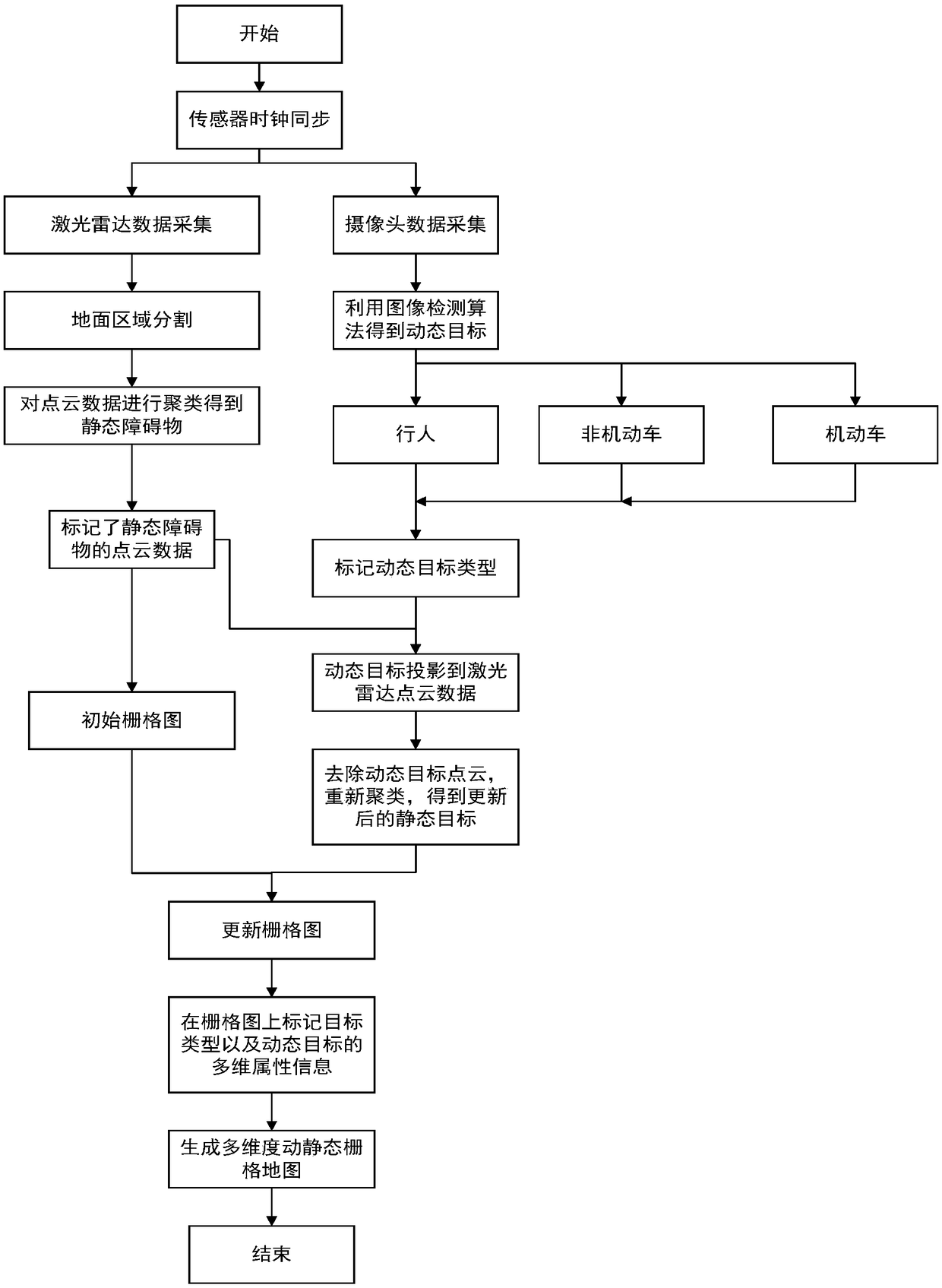
[0026] see attached figure 1 , 2 , this embodiment provides a method for constructing a dynamic and static grid map by fusion of lidar and visual sensors, which jointly calibrates the lidar and visual sensors of driving vehicles, identifies static targets and dynamic targets by classification, and ensures time synchronization of sensor information ; During the driving process of the vehicle, the following steps are performed in each cycle to construct a multi-dimensional dynamic and static grid map. The specific steps are as follows:

[0027] Step 1. Use Velodyne 16-line lidar to collect lidar point cloud data. Ground region segmentation using point cloud data elevation information. Clustering the point cloud data to obtain static targets, the static targets, that is, static obstacles, do not need to distinguish their types, only their p...


PUM


Abstract

The invention relates to a laser radar and visual sensor fused dynamic grid map structuring method. The laser radar and visual sensor fused dynamic grid map structuring method comprises combining thelaser radar and the visual sensors of a designated traveling vehicle, marking static targets and dynamic targets through classification, and ensuring information time synchronization of the sensors; during a vehicle traveling process, structuring a multi-dimensional dynamic-static grid map. The laser radar and visual sensor fused dynamic grid map structuring method has the advantage that, comparedwith the prior art, the structured map is the multi-dimensional dynamic-static grid map and is generated during the vehicle travelling process. The structured dynamic-static grip map can show the road states around the current vehicle such as drivable areas, surrounding obstacles and the motion states of the obstacles to provide information for safe driving of the vehicle in a current local areaand to provide a self-driving vehicle with safe, reliable and predictable local road area information, and meanwhile, the visual sensors of the self-driving vehicle can help enrich the information ofthe dynamic-static grid map.

Description

technical field [0001] The invention belongs to the technical field of unmanned vehicles, and in particular relates to a method for constructing a dynamic and static grid map by fusion of a laser radar and a visual sensor. Background technique [0002] The current description of the environment can be roughly divided into grid maps, geometric information maps and topological maps. The grid map method divides the entire environment into several grids of the same size, and points out whether there are obstacles in each grid. In the field of unmanned vehicles, using lidar to generate a grid map of the current driving area of ​​the vehicle in real time, marking the drivable area, the orientation and speed of obstacles, etc. basic technology. [0003] The existing methods of using lidar to generate raster maps mainly focus on the construction of the drivable area, and lack the identification and behavioral characteristics estimation of traffic actors such as motor vehicles, bic...

Claims


Application Information

Patent Timeline
Patent Type & Authority Applications(China)
IPC IPC(8): G01C21/32G01C11/00G01S17/93G01S17/02
CPCG01C11/00G01C21/32G01S17/86G01S17/931
Inventor 王晓东张天雷何贝刘鹤云郑思仪
Owner 上海主线科技有限公司
Why Eureka
Try Eureka