Eureka AIR delivers breakthrough ideas for toughest innovation challenges, trusted by R&D personnel around the world.

Automatic generation method for high-precision map based on high precision positioning and lane line recognition

A technology for lane line recognition and automatic generation, applied in directions such as road network navigators, can solve the problems of complex calculation process, time-consuming and labor-intensive, and time-consuming production process, so as to reduce complexity, avoid high error rate, and avoid labor consumption. Effect

Active Publication Date: 2019-03-15
禾多科技(北京)有限公司
View PDF10 Cites 9 Cited by
  • Summary
  • Abstract
  • Description
  • Claims
  • Application Information

AI Technical Summary

Problems solved by technology

Unmanned driving needs to compare the information collected by the sensor with the stored high-precision map to judge the position and direction, so as to ensure the safe driving of the unmanned vehicle to the destination. Therefore, the accuracy of high-precision map data collection is very important for unmanned driving. Crucial; the production of traditional high-precision maps requires a lot of manpower to label, which is not only time-consuming and labor-intensive, but also has a high error rate due to errors caused by manual labeling, which is not conducive to the development of unmanned driving. Nowadays, the production of high-precision maps , due to high precision requirements, complex calculation process, and relatively time-consuming production process, it is necessary to provide a high-precision map that can automatically splice lanes based on high-precision positioning and lane line recognition, and takes a short time.

Method used


Image

  • Automatic generation method for high-precision map based on high precision positioning and lane line recognition
  • Automatic generation method for high-precision map based on high precision positioning and lane line recognition
  • Automatic generation method for high-precision map based on high precision positioning and lane line recognition

Examples


Embodiment Construction

[0055] The present invention will be further described in detail below in conjunction with the accompanying drawings, so that those skilled in the art can implement it with reference to the description.

[0056] It should be understood that terms such as "having", "comprising" and "including" used herein do not exclude the presence or addition of one or more other elements or combinations thereof.

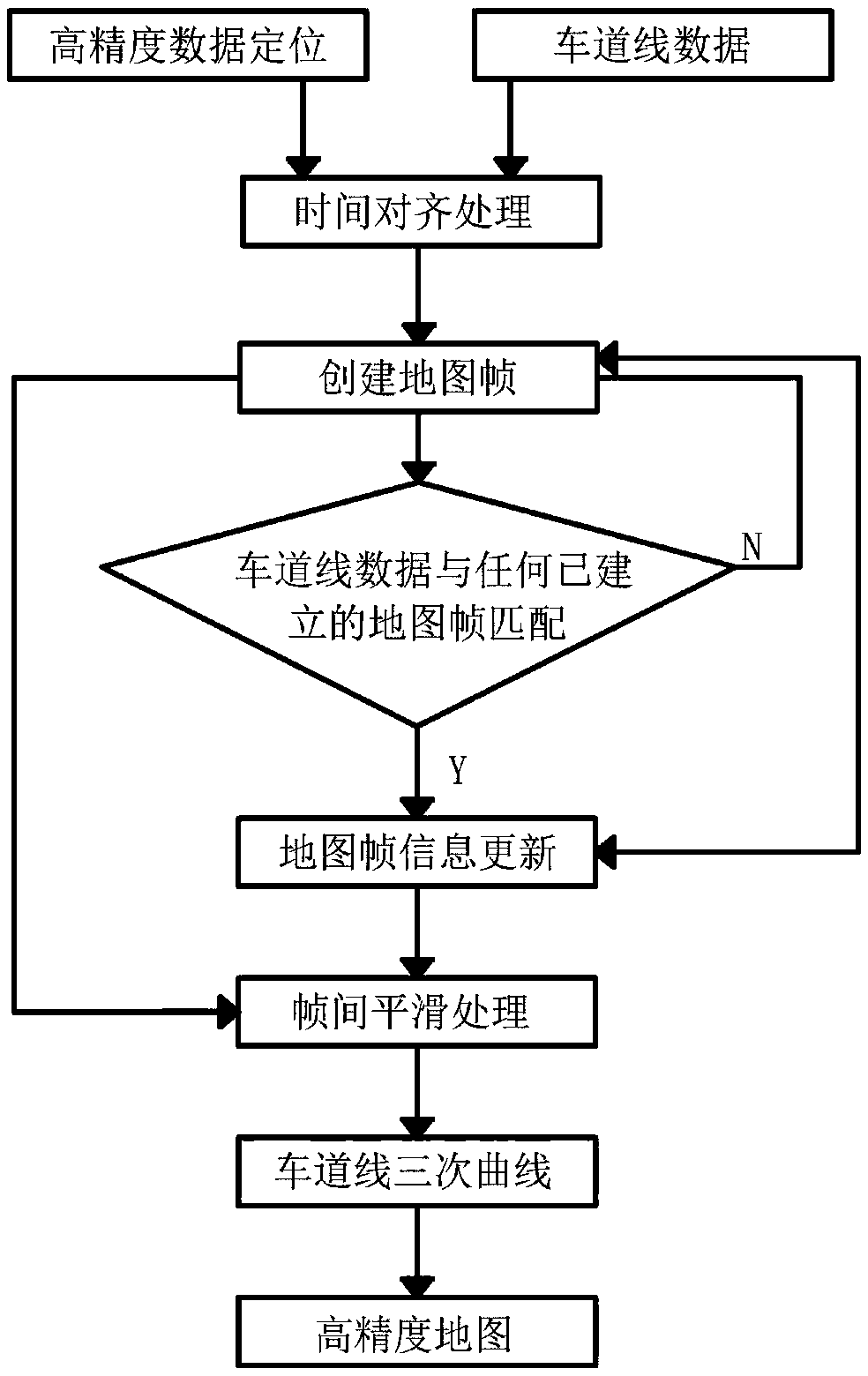
[0057] Such as figure 1 As shown, the present invention provides a method for automatically generating a high-precision map based on high-precision positioning and lane line recognition, including:

[0058] Step 1. Synchronize the high-precision positioning data acquired each time with the lane line data through time alignment processing, so as to obtain the position and attitude of the synchronized high-precision positioning data.

[0059] Step 2. Create a map frame from the synchronized lane line data and high-precision positioning data obtained in step 1, and store it in a map ...


PUM


Abstract

The invention discloses an automatic generation method for a high-precision map based on high precision positioning and lane line recognition. The automatic generation method comprises the following steps: enabling high precision positioning data acquired each time to be synthesized with lane line data; establishing map frames by using synthesized data and storing the map frames into a map frame database; matching newly-acquired lane line data with all established map frames; if the matching is failed, establishing a new map frame; if the matching succeeds, updating information of the established map frame; carrying out interframe smooth processing on all existing map frames in the established map frames so as to obtain cubic curves subjected to smooth processing; splicing the cubic curvesto generate the high-precision map. The automatic generation method disclosed by the invention is used for generating the high-precision map which is accurate to lane line and can automatically splice the lane lines based on the high precision positioning; the complexity of generating the high precision map is reduced, and the problems that a traditional high precision map is generated by consuming a large amount of labor and has a high error rate are avoided.

Description

technical field [0001] The invention relates to the field of unmanned driving technology, in particular to a method for automatically generating a high-precision map based on high-precision positioning and lane line recognition. Background technique [0002] As a scarce resource and rigid demand in the field of unmanned driving, high-precision maps play a central role in the entire field. They can help unmanned vehicles perceive complex information on the road in advance, such as slope, curvature, heading, etc., combined with intelligent path planning, make unmanned vehicles Making correct decisions is an indispensable source of data for driverless vehicles. Unmanned driving needs to compare the information collected by the sensor with the stored high-precision map to judge the position and direction, so as to ensure the safe driving of the unmanned vehicle to the destination. Therefore, the accuracy of high-precision map data collection is very important for unmanned drivin...

Claims


Application Information

Patent Timeline
Patent Type & Authority Applications(China)
IPC IPC(8): G01C21/32
CPCG01C21/32
Inventor 胡禹超戴震
Owner 禾多科技(北京)有限公司
Why Eureka
Eureka Blog
Learn More