
An urban entity boundary identification method integrating surface temperature and building index

A surface temperature and boundary recognition technology, applied in character and pattern recognition, instruments, calculations, etc., can solve problems such as mis-extraction of non-urban impermeable surfaces, low resolution of remote sensing lights at night, errors in urban boundary recognition results, etc., to achieve correct High efficiency and simple operation

Active Publication Date: 2019-04-09
CHINA UNIV OF MINING & TECH
View PDF6 Cites 12 Cited by
  • Summary
  • Abstract
  • Description
  • Claims
  • Application Information

AI Technical Summary

Problems solved by technology

[0003] At present, the extraction method of the entity boundary of urban built-up area usually uses technical methods such as multispectral remote sensing data, night light data and land price equilibrium model to identify and define the urban boundary, but the above methods have many shortcomings: such as the spectral characteristics of multispectral remote sensing It is easy to extract non-urban impermeable surfaces by mistake; the resolution of remote sensing of lights at night is low, resulting in certain errors between the identification results of urban boundaries and the actual situation; land price equilibrium models do not take into account the spatial heterogeneity of land prices, and most The ecological and environmental effects of physical boundary expansion are included in the decision-making analysis framework, etc.

Method used


Image

  • An urban entity boundary identification method integrating surface temperature and building index
  • An urban entity boundary identification method integrating surface temperature and building index
  • An urban entity boundary identification method integrating surface temperature and building index

Examples


Embodiment Construction

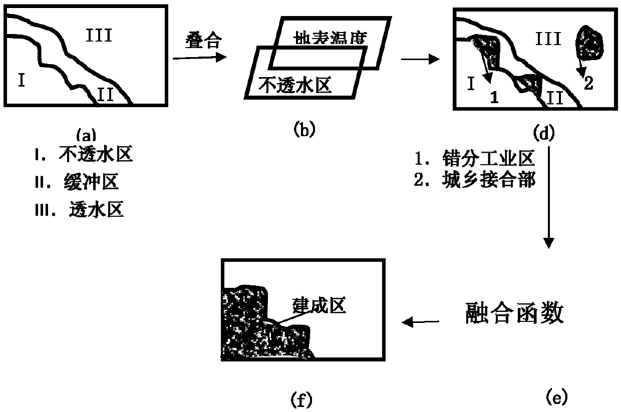
[0055] Such as figure 1 As shown, a method for identifying the boundaries of urban built-up areas that combines surface temperature and building indices includes the following steps:

[0056] Step 1: Image preprocessing

[0057] It mainly includes radiometric calibration, atmospheric correction, frame mosaic, image cropping, etc. The atmospheric correction adopts FLAASH atmospheric correction.

[0058] Step 2: Inversion of surface temperature

[0059] Construct the LST inversion model of the surface temperature, and use the single-window algorithm to calculate the surface temperature

[0060] LST={a(1-C-D)+[b(1-C-D)+C+D]T senor -DT a} / C

[0061] LST is the surface temperature; a and b are constants, a=-67.3554, b=0.45861; T senor is the brightness temperature, Ta is the average atmospheric temperature C=ετ;, D=(1-τ)[1+(1-ε)τ], ε is the surface emissivity, and τ is the atmospheric transmittance.

[0062] Step 2.1: Calculate the brightness temperature T senor

[0063] L ...


PUM


Abstract

The invention discloses a data fusion-based city built-up area entity boundary identification method. According to the method, the urban built-up area entity boundary can be more accurately positionedby combining the surface temperature and the building index of remote sensing inversion, the defect that urban edge industrial areas and urban and rural joint parts are difficult to identify is overcome, and the urban built-up area entity boundary is more scientifically identified. In addition, the data source only needs Landsat data, the operation is simple, the accuracy is high, and the boundary of the city built-up area can be quickly and accurately obtained. A large number of experiment results show that the boundary recognition accuracy rate reaches 94% or above, and the method is suitable for the fields of territory space planning, geographic national condition monitoring, urban spreading treatment analysis and the like.

Description

technical field [0001] The invention belongs to the fields of land space planning and urban-rural planning, and in particular relates to a method for identifying the entity boundary of urban built-up areas by integrating surface temperature and building index. Background technique [0002] With the unavoidable global urban expansion and the increasing plight of ecological damage, the expansion of urban built-up areas in my country presents a more prominent unbalanced third-line dilemma (the expansion elasticity breaks through the "reasonable boundary", the urban environment approaches the "ecological bottom line" and the development trend exceeds the "indicator upper line") , therefore, how to scientifically identify the physical boundary of urban expansion and regulate and highlight the dilemma has become a major theoretical proposition and technical problem for my country's urban sustainable development and social management. [0003] At present, the extraction method of th...

Claims


Application Information

Patent Timeline
Patent Type & Authority Applications(China)
IPC IPC(8): G06K9/46G06K9/34
CPCG06V10/267G06V10/457Y02A30/60
Inventor 李效顺张川王状夏嘉南魏旭晨张琦王月香
Owner CHINA UNIV OF MINING & TECH
Learn More