A mass remote sensing data efficient organization and fast retrieval method in a cloud computing environment

A technology of massive remote sensing data and cloud computing environment, applied in structured data retrieval, database index, geographic information database, etc., can solve the problem of limited application, unfavorable for large data volume, multi-task and multi-node parallel computing, and lack of logic in tiles. Relevance and other issues, to achieve the effect of improving retrieval efficiency, improving distributed access efficiency, and improving spatiotemporal logical correlation

Inactive Publication Date: 2019-04-16
CHINA UNIV OF GEOSCIENCES (WUHAN)
View PDF4 Cites 17 Cited by
  • Summary
  • Abstract
  • Description
  • Claims
  • Application Information

AI Technical Summary

Problems solved by technology

However, there are still the following problems in this spatio-temporal sequence organization model of remote sensing big data: (1) The remote sensing tile data does not have a spatio-temporal index, and there is a lack of logical correlation between tiles, and the retrieval efficiency of remote sensing tile data is not high
(2) Multi-process parallel data retrieval and access based on the Dask parallel computing library is not conducive to large data volume, multi-task, multi-node parallel computing, and cannot meet the rapid retrieval and access requirements of massive remote sensing tile data
The insufficiency of the above-mentioned remote sensing data cube model for the organization and management of massive tile data restricts its application in information extraction and mining to a certain extent.

Method used


Image

  • A mass remote sensing data efficient organization and fast retrieval method in a cloud computing environment
  • A mass remote sensing data efficient organization and fast retrieval method in a cloud computing environment
  • A mass remote sensing data efficient organization and fast retrieval method in a cloud computing environment

Examples


Embodiment Construction

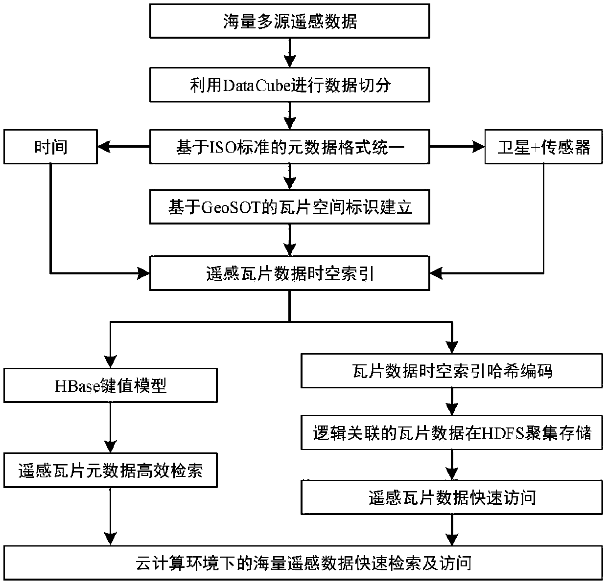
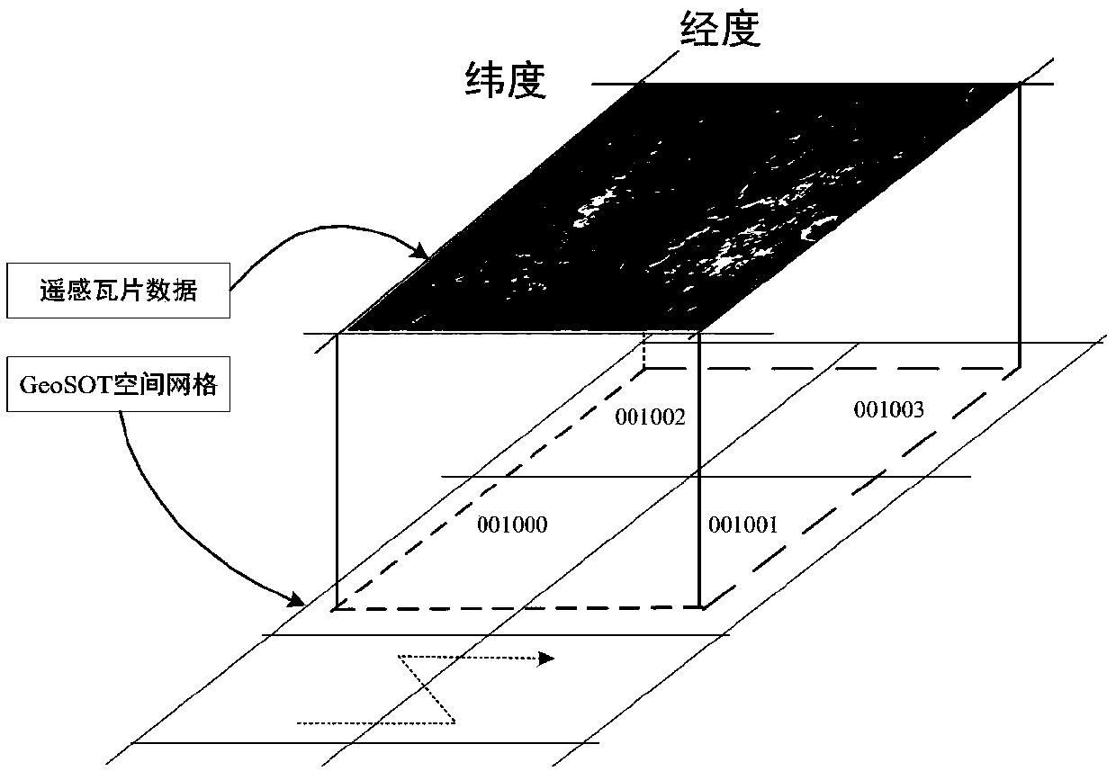
[0022] In order to make the purpose, technical solution and advantages of the present invention clearer, the embodiments of the present invention will be further described below in conjunction with the accompanying drawings.

[0023] Please refer to figure 1 , the embodiment of the present invention provides a method for efficient organization and fast retrieval of massive remote sensing data in a cloud computing environment, comprising the following steps:

[0024] S1 obtains standard multi-source heterogeneous remote sensing data according to the unified format of ISO 19115-2 geographic information metadata standard for multi-source heterogeneous remote sensing data metadata;

[0025] The ISO 19115-2 geographic information metadata standard mainly defines the metadata schema used to describe geographic information and services, and provides other attribute information such as identification, quality, space, time, content, spatial reference system, and distribution of geograp...


PUM


Abstract

The invention provides a mass remote sensing data efficient organization and fast retrieval method in a cloud computing environment. The mass remote sensing data efficient organization and fast retrieval method in the cloud computing environment comprises the following steps that S1, alloing multi-source heterogeneous remote sensing data metadata to be subjected to ISO 19115-based retrieval; 2, obtaining standard multi-source heterogeneous remote sensing data through a geographic information metadata standard unified format; S2, constructing a GeoSOT space division grid for the standard multi-source heterogeneous remote sensing data to obtain remote sensing tile data, wherein the remote sensing tile data has a space identifier with a uniform reference; S3, constructing a space-time index for the multi-source remote sensing tile data based on the spatial identifier; And S4, constructing a Hash algorithm-based multi-source remote sensing tile data distributed storage optimization strategy according to the space-time index of each split tile in the multi-source remote sensing tile data, and aggregating and storing the multi-source remote sensing tile data logically associated with theHash value in the same data node. The method has the beneficial effect that the retrieval efficiency and the distributed access efficiency of mass data are improved.

Description

technical field [0001] The invention relates to the technical field of remote sensing data retrieval and access, in particular to a method for efficient organization and rapid retrieval of massive remote sensing data in a cloud computing environment. Background technique [0002] The development of earth observation technology has resulted in a continuous increase in the volume of remote sensing data, shortened data acquisition and update cycles, and increasingly time-sensitive data. The total amount of data stored in satellite data centers around the world has exceeded several PB, and satellite remote sensing has entered the era of big data. On the one hand, remote sensing big data provides sufficient data sources for land and resources census, environmental pollution prevention and control, and disaster prevention and mitigation. It has brought great challenges, making the valuable earth observation information hidden in the massive remote sensing data unable to be quickl...

Claims


Application Information

Patent Timeline
Patent Type & Authority Applications(China)
IPC IPC(8): G06F16/29G06F16/22
Inventor 阎继宁王力哲黄晓辉成路肖
Owner CHINA UNIV OF GEOSCIENCES (WUHAN)
Why Eureka
Try Eureka