Multisource real-time land subsidence and horizontal displacement monitoring system and method

A technology of land subsidence and horizontal displacement, used in hydrostatic leveling, measuring devices, instruments, etc., can solve the problems of monitoring data analysis and effect influence, conflicting, single monitoring data, etc., to achieve results analysis and monitoring reliability improvement , Reasonable design, the effect of reducing economic losses

Inactive Publication Date: 2019-05-03
CHINA RAILWAY SIYUAN SURVEY & DESIGN GRP
View PDF3 Cites 6 Cited by
  • Summary
  • Abstract
  • Description
  • Claims
  • Application Information

AI Technical Summary

Problems solved by technology

[0003] Traditional land subsidence measurement methods include leveling, bedrock and layered standard measurement, and the measured data is sent to the data analysis module, which can analyze the land subsidence and horizontal displacement rate based on these measurement data. The accuracy of these methods is It is very high, but it can only be carried out in a small range. At present, when monitoring land subsidence, the above three methods are used independently. During the monitoring process, it is easy to have single or even contradictory monitoring data, and the quality of the results is not up to standard, etc. Problems that have a negative impact on the analysis and results of land subsidence monitoring data

Method used


Image

  • Multisource real-time land subsidence and horizontal displacement monitoring system and method
  • Multisource real-time land subsidence and horizontal displacement monitoring system and method

Examples


Embodiment Construction

[0024] The following will clearly and completely describe the technical solutions in the embodiments of the present invention with reference to the accompanying drawings in the embodiments of the present invention. Obviously, the described embodiments are only a part of the present invention, not all embodiments. Based on the embodiments of the present invention, all other embodiments obtained by persons of ordinary skill in the art without making creative efforts belong to the protection scope of the present invention.

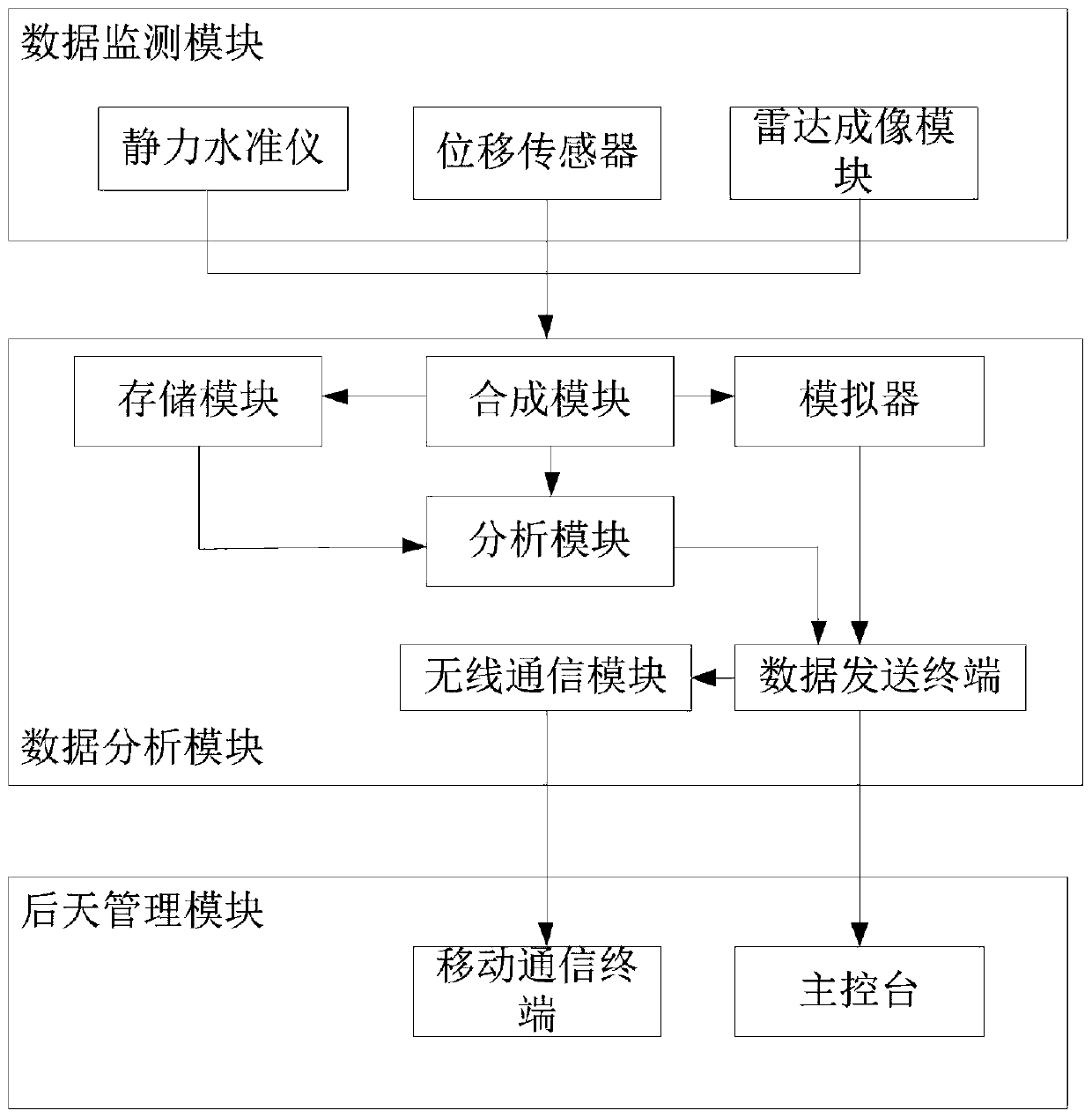
[0025] Such as figure 1 As shown, as a first aspect of the present invention, a multi-source real-time ground subsidence and horizontal displacement monitoring system is provided, including a reference pole, a main console, a data monitoring module for collecting ground subsidence and horizontal displacement data of a monitoring body, A data analysis module for analyzing the collected data and judging the degree of ground subsidence and horizontal displacemen...


PUM


Abstract

The invention relates to a multisource real-time land subsidence and horizontal displacement monitoring system and method. The system comprises a reference rod, a master console, a data monitoring module for collecting land subsidence and horizontal displacement data of a monitoring body, and a data analysis module for analyzing the collected data and determining the land subsidence and horizontaldisplacement degree according to an analysis result; the data monitoring module is arranged in the ground where the monitoring body is placed; the reference rod is arranged in a preset reference point; the data monitoring module comprises a static force leveling instrument, a displacement sensor and a radar imaging module; and the reference rod is internally provided with the static force leveling instrument and displacement sensor as reference. According to the system and method , design is reasonable, mutual verification and comparison are realized via the static force leveling instrument,displacement sensor and radar imaging while a traditional ground monitoring technology is used, more comprehensive and accurate land subsidence data can be obtained, and the result can be analyzed andmonitored more reliably.

Description

technical field [0001] The invention relates to the technical field of geological disaster monitoring systems, in particular to a multi-source real-time land subsidence and horizontal displacement monitoring system and method. Background technique [0002] In recent years, various geological disaster monitoring technologies have been more and more used in geological disaster monitoring. Real-time monitoring and prevention of geological disasters by establishing a scientific and practical geological disaster monitoring system can directly reduce and avoid casualties and economic losses. Geological disaster monitoring is not only the key work and key link of geological disaster research, but also the necessary prerequisite and key measures for effective prevention and control of geological disasters. Timely and accurate predictions can only be made on the basis of comprehensive monitoring methods and scientific analysis of a large number of reliable monitoring data. [0003]...

Claims


Application Information

Patent Timeline
Patent Type & Authority Applications(China)
IPC IPC(8): G01C5/04G01B21/02
Inventor 饶雄陶灿曹成度滕焕乐
Owner CHINA RAILWAY SIYUAN SURVEY & DESIGN GRP
Why Eureka
Try Eureka