Unlock instant, AI-driven research and patent intelligence for your innovation.

A Method to Directly Generate Structural Maps Using Prestack Depth Migration Results

A technology of pre-stack depth migration and pre-stack time migration, applied in seismic signal processing and other directions, can solve the problems of large depth error, large structural map error, large human factors, etc., to achieve error elimination, accurate velocity depth model, Good image quality

Active Publication Date: 2021-01-19
成都捷科思石油天然气技术发展有限公司
View PDF6 Cites 0 Cited by
  • Summary
  • Abstract
  • Description
  • Claims
  • Application Information

AI Technical Summary

Problems solved by technology

Although the structural map is generated in this way, after multiple speed conversions, the human factors are relatively large, and it is easy to cause the distortion of the speed on the plane, that is, the depth error on the plane is relatively large, up to hundreds of meters
If you drill with reference to the structural map, it is easy to miss oil and gas reservoirs, which in turn leads to the generation of abandoned wells
[0015] To sum up, it can be seen that the above-mentioned processing method has a relatively large error in the structural map obtained by the above-mentioned processing method for areas with complex geological structures, such as large surface fluctuations, complex underground structures, and well-developed lateral overthrust fault zones on both flanks, which can reach hundreds of meters.
In the case of such a large error, if the drilling is guided by the structural map obtained from the above processing flow chart, it is easy to miss oil and gas reservoirs and cause huge losses
The cost of drilling is high, and the cost of a single well can be tens of millions, and the loss is very huge
Therefore, the structural map obtained by the above-mentioned processing flow is of poor guiding significance for geologists to determine underground well location targets in areas with complex geological structures such as large surface undulations, complex underground structures, and well-developed lateral overthrust fault zones on both wings. A composition map with guiding significance has become an urgent need

Method used


Image

  • A Method to Directly Generate Structural Maps Using Prestack Depth Migration Results
  • A Method to Directly Generate Structural Maps Using Prestack Depth Migration Results
  • A Method to Directly Generate Structural Maps Using Prestack Depth Migration Results

Examples


Embodiment 1

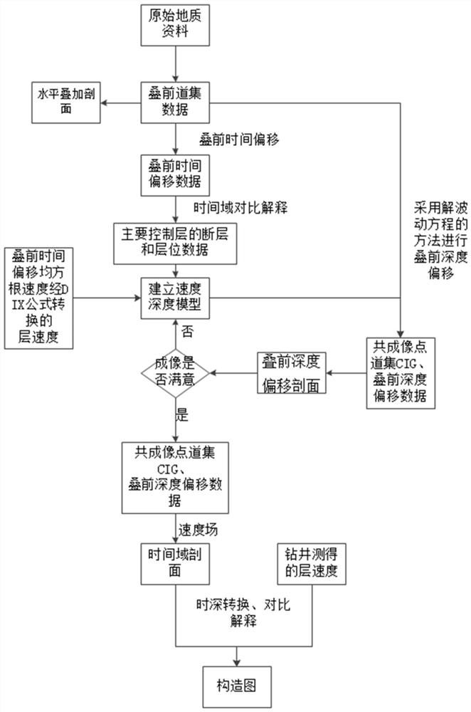
[0158]Taking a region with complex geological structures such as large surface undulations, complex underground structures, and well-developed flank overthrust fault zones, image 3 Interpreted for time-domain comparisons, Figure 4 Interpret stereoscopic displays for time-domain comparisons; Figure 5 For the establishment of the time domain entity model, Figure 6 is the root mean square velocity volume (Vrms) of prestack time migration, Figure 7 is the interlayer velocity volume converted from the root mean square velocity volume by the DIX formula, Figure 8 Based on the layer velocity body, the layer velocity measured by well logging, mud logging and VSP is used for correction and then added to the comprehensive velocity body obtained by the solid model, Figure 9 It is a plane distribution comparison diagram of root mean square velocity (left), layer velocity (middle) and comprehensive velocity (right) along a certain layer, Figure 10 In order to use the time-domai...

Embodiment 2

[0161] Figure 20 It is a comparison between the old image of pre-stack depth migration profile imaging obtained by conventional methods and the new image of pre-stack depth migration profile imaging obtained by the method of this application in another work area. The well was fixed according to the old results. From the profile of the well, the target position data of the original design is relatively continuous, and there is no complicated situation. However, during the actual drilling process, there are complicated situations, which are quite different from the original design. . The new results obtained after using the method of this application for pre-stack depth migration have a certain improvement in profile imaging quality compared with the old results, and the position of the target layer height of the new results is about 500m westward offset from the old results. The position of the bottom of the well The continuity of the data on the depth migration profile is po...


PUM


Abstract

The invention relates to the field of seismic data interpretation and discloses a method for directly generating a structure map by utilizing a prestack depth migration result. The method comprises the following steps: 1) obtaining prestack trace gather data; 2) obtaining a pre-stack time migration profile, and carrying out comparative interpretation; 3) obtaining a comprehensive initial velocityfield and establishing a velocity depth model; 4) carrying out prestack depth migration by combining the prestack trace gather data and the velocity depth model to obtain a depth profile, then, carrying out comparative interpretation, establishing a depth domain entity model, carrying out residual velocity pickup, carrying out optimization iteration on the velocity depth model further, and judgingwhether imaging is satisfactory after multiple iterations; and 5) analyzing anisotropic parameters, obtaining a pre-stack depth migration profile, and obtaining the structure map by utilizing the interpretation result. For complex geological structure areas with large surface undulation, complex ventral structure and well-developed two-wing transversal overthrust fault zone and the like, the obtained structure map has small error, so that the map can better guide to determine an underground well location target.

Description

technical field [0001] The invention relates to the field of seismic data interpretation, in particular to a method for directly generating a structural map using pre-stack depth migration results. Background technique [0002] Seismic exploration is a geophysical exploration method that uses the difference in elasticity and density of underground media to infer the nature and shape of underground rock formations by observing and analyzing the response of the earth to artificially excited seismic waves. Seismic exploration is an important means of surveying oil and natural gas resources before drilling and is widely used. Seismic exploration is of great significance to guide drilling. [0003] At present, seismic data processing usually adopts figure 1 Process shown: [0004] 1. First, use the original geological data, mainly to obtain pre-stack gather data for source data and stacked shot data, and perform horizontal stacking to suppress interference waves; [0005] 2. ...

Claims


Application Information

Patent Timeline
Patent Type & Authority Patents(China)
IPC IPC(8): G01V1/30G01V1/32
Inventor 贺燕冰黄君雷治安张海杰唐大海王维于靖齐勋张晓丹陈欣
Owner 成都捷科思石油天然气技术发展有限公司