
A multi-agent-based urban population spatial distribution estimation method and device

A multi-agent, spatial distribution technology, applied in the field of urban population spatial distribution estimation methods and devices, can solve the problems of low conformity, inability to reflect the spatial distribution characteristics of population data, and low spatial resolution, so as to achieve strong practical significance and improve The effect of urban population spatial distribution accuracy

Inactive Publication Date: 2019-05-10
CHINESE ACAD OF SURVEYING & MAPPING
View PDF8 Cites 3 Cited by
  • Summary
  • Abstract
  • Description
  • Claims
  • Application Information

AI Technical Summary

Problems solved by technology

[0003] The currently widely used population distribution data is usually based on the administrative division as a unit, and the typical population distribution data obtained through census, sampling statistics, etc. have the following three deficiencies in practical applications: First, the time resolution is low The national census is held every 10 years, and the data update cycle is long, which makes it difficult to accurately reveal the population change situation; second, the spatial resolution is low, and the population data obtained with the administrative district as the unit is evenly distributed within the administrative unit, which cannot reflect the population data Third, it is not conducive to multi-source data fusion and comprehensive spatial analysis. There is a problem of spatial mismatch between statistical data based on administrative districts and physical geographic units, which limits multidisciplinary interaction based on demographic data.
[0006] However, when the multi-agent model in the prior art considers the factors affecting residents’ living choices, it considers the attribute factors of the buildings and buildings themselves, and does not consider the environmental factors of the public service facilities around the buildings and buildings. With the rapid development of the urban economy, the living choices of residents are actually more related to the public service facilities around the houses and buildings. Therefore, the spatial distribution of the urban population obtained by the existing technical research is less consistent with the actual situation in the lives of residents. , the practical significance is not strong

Method used


Image

  • A multi-agent-based urban population spatial distribution estimation method and device
  • A multi-agent-based urban population spatial distribution estimation method and device
  • A multi-agent-based urban population spatial distribution estimation method and device

Examples


Embodiment Construction

[0041] In order to make the purpose, technical solution and advantages of the present invention clearer, the present invention will be described in more detail below in conjunction with the accompanying drawings and embodiments.

[0042] It should be noted that the described embodiments are some of the embodiments of the present invention, but not all of the embodiments. In the case of no conflict, the embodiments and the features of the embodiments in the application can be combined with each other. Based on the embodiments of the present invention, all other embodiments obtained by persons of ordinary skill in the art without creative efforts fall within the protection scope of the present invention.

[0043] In this article, "first", "second", attributes "A", "B", "C", etc. are only used to distinguish each other, rather than to indicate their importance and order.

[0044] The division of units and subunits herein is only a division of logical functions, and there may be o...


PUM


Abstract

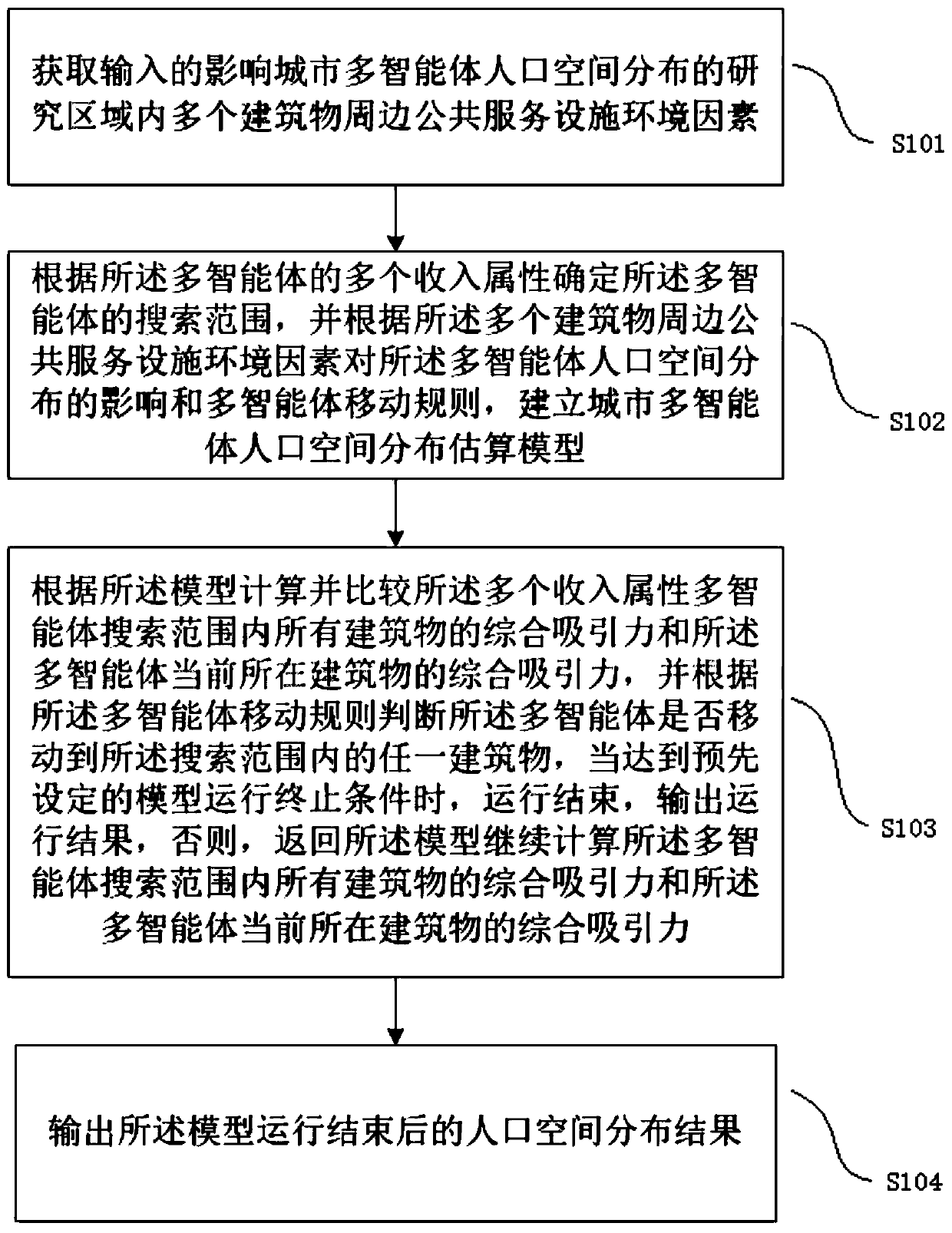
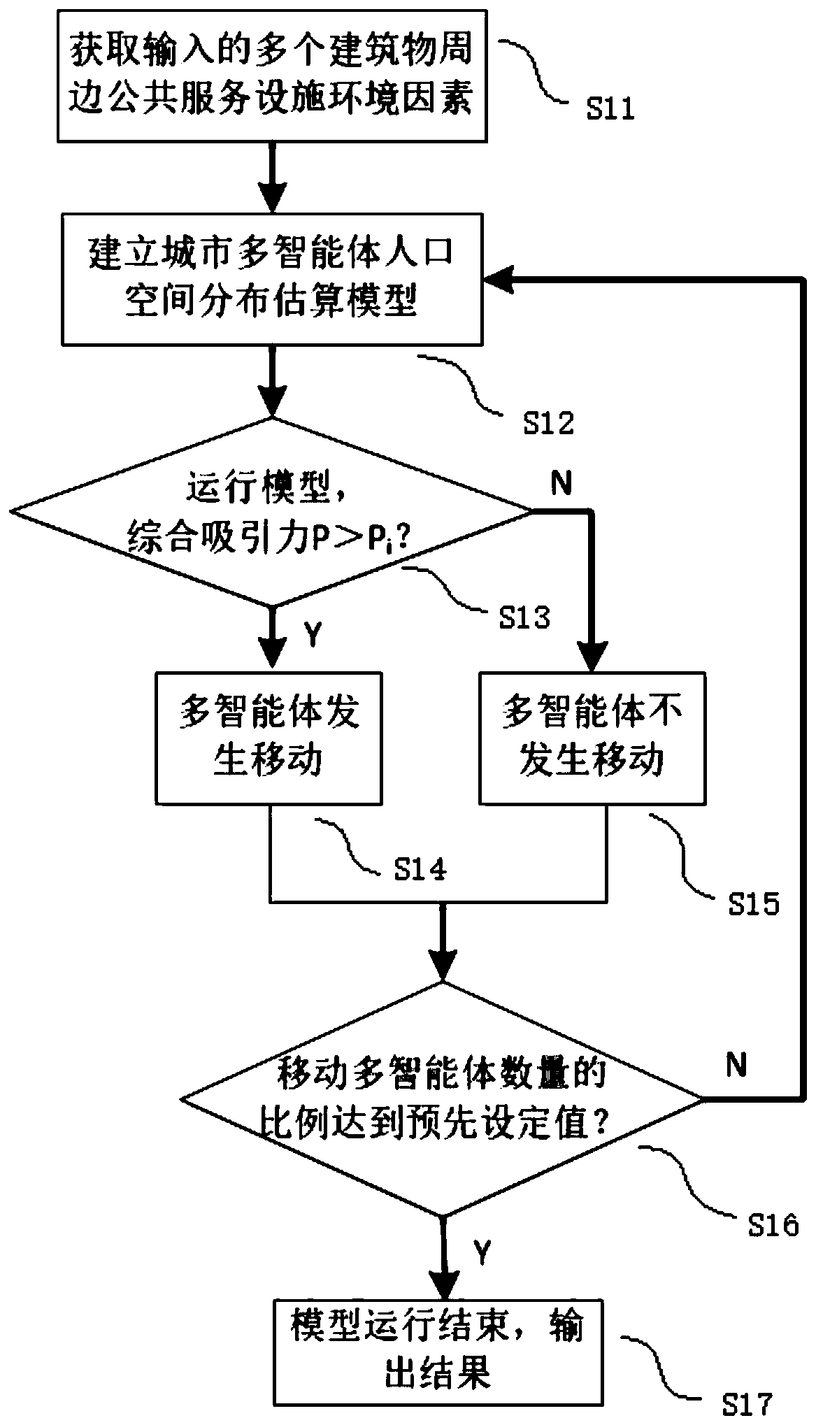
The invention relates to the field of population spatial distribution, and discloses a multi-agent-based urban population spatial distribution estimation method and device. The method comprises the steps of acquiring input public service facility environment factors around multiple buildings in a research area influencing urban multi-agent population spatial distribution; establishing an urban multi-agent population spatial distribution estimation model; calculating and comparing the comprehensive attraction of all the buildings in the multi-agent search range and the comprehensive attractionof the building where the multi-agent is located currently according to the model; judging whether the multi-agent moves to any building in a search range or not, ending operation and outputting an operation result when a preset model operation termination condition is met, otherwise, returning to the model to continue to calculate; outputting results. According to the invention, the urban population spatial distribution estimation model is established according to the environmental factors of the public service facilities around the building influencing living selection, and a population spatial distribution result that are more consistent with actual conditions in life can be obtained.

Description

technical field [0001] The invention relates to the field of population spatial distribution, and discloses a multi-agent-based urban population spatial distribution estimation method and device. Background technique [0002] Cities are the concentration of population, capital and technology. As human settlements, the development of cities is closely related to population distribution. The spatial distribution of population refers to the geographical distribution of population at a certain point in time, which is the spatial manifestation of population process and the core issue of population geography research. The spatial distribution of population is closely related to urban planning and economic development, and is also the key to solving the shortage of natural resources and uneven regional development. [0003] The currently widely used population distribution data is usually based on the administrative division as a unit, and the typical population distribution data ...

Claims


Application Information

Patent Timeline
Patent Type & Authority Applications(China)
IPC IPC(8): G06F17/50
Inventor 董春尹诗画刘纪平张玉康风光刘新飞
Owner CHINESE ACAD OF SURVEYING & MAPPING
Learn More