Method for compiling top surface temperature contour map of oil region heat reservoir
A contour map and thermal reservoir technology, applied in buildings and other directions, can solve the problems of limited number of well points for temperature measurement, low reliability of reservoir geothermal distribution map, etc., and achieve high-precision results
- Summary
- Abstract
- Description
- Claims
- Application Information
AI Technical Summary
Problems solved by technology
Method used
Image
Examples
Embodiment 1
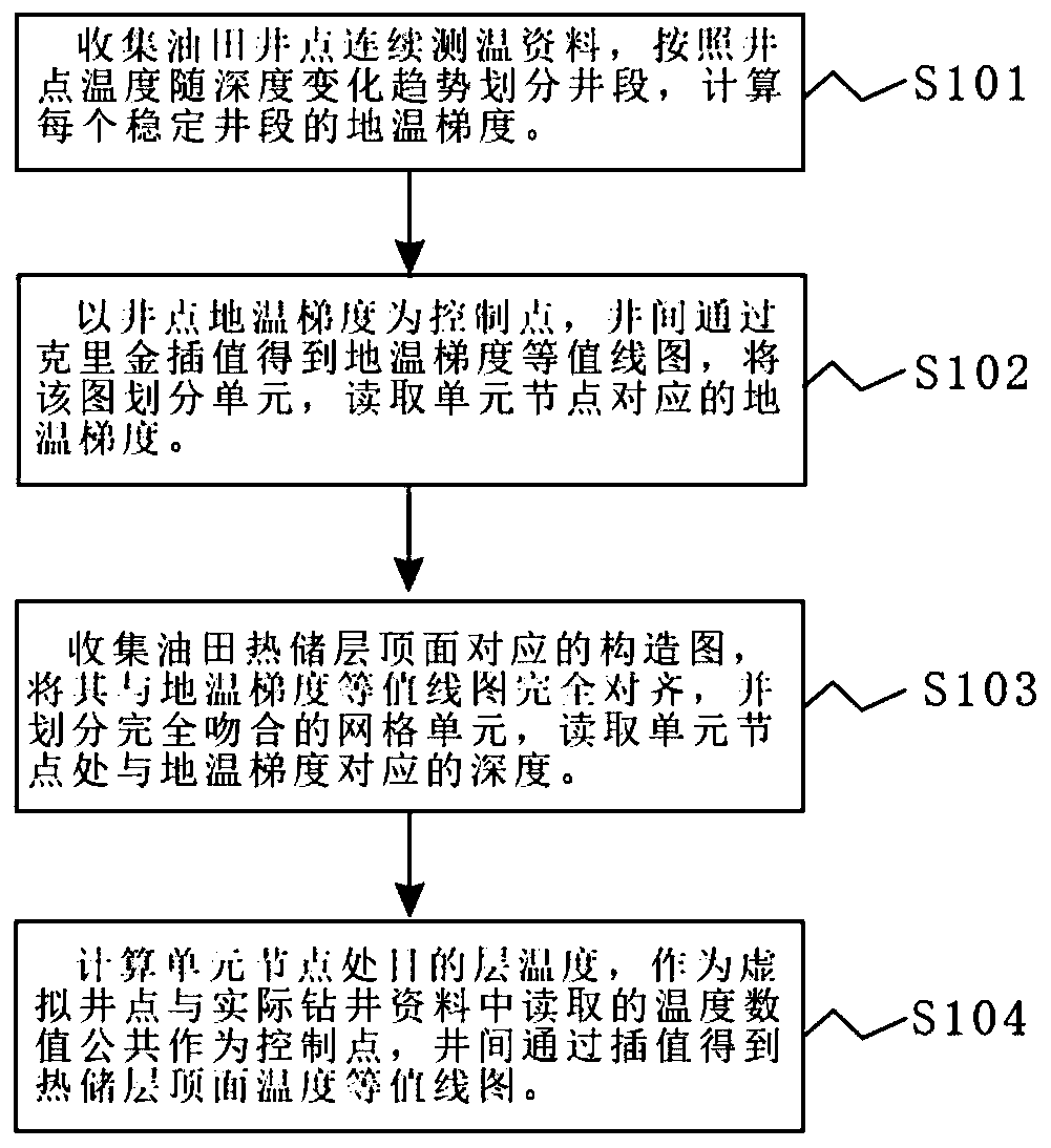
[0025] Example 1: See Figure 1-5 , a method for compiling a temperature contour map of the top surface of a thermal reservoir in an oil area, the specific process is as follows: Step A, collecting continuous temperature measurement data at existing well points in the oil field, observing the variation law of the well point temperature with depth, and calculating the temperature of the well point Geothermal gradients corresponding to different depth sections; step B, take the geothermal gradient of the temperature measurement well point as the control point, and use Kriging interpolation method between wells to draw the geothermal gradient distribution map of different depth sections; step C, collect the top surface structure of the target layer At the same time, the top structural map and the geothermal gradient contour map are divided into units, and the unit positions and control ranges corresponding to the two sets of maps are completely consistent; the geothermal gradient ...
Embodiment 2
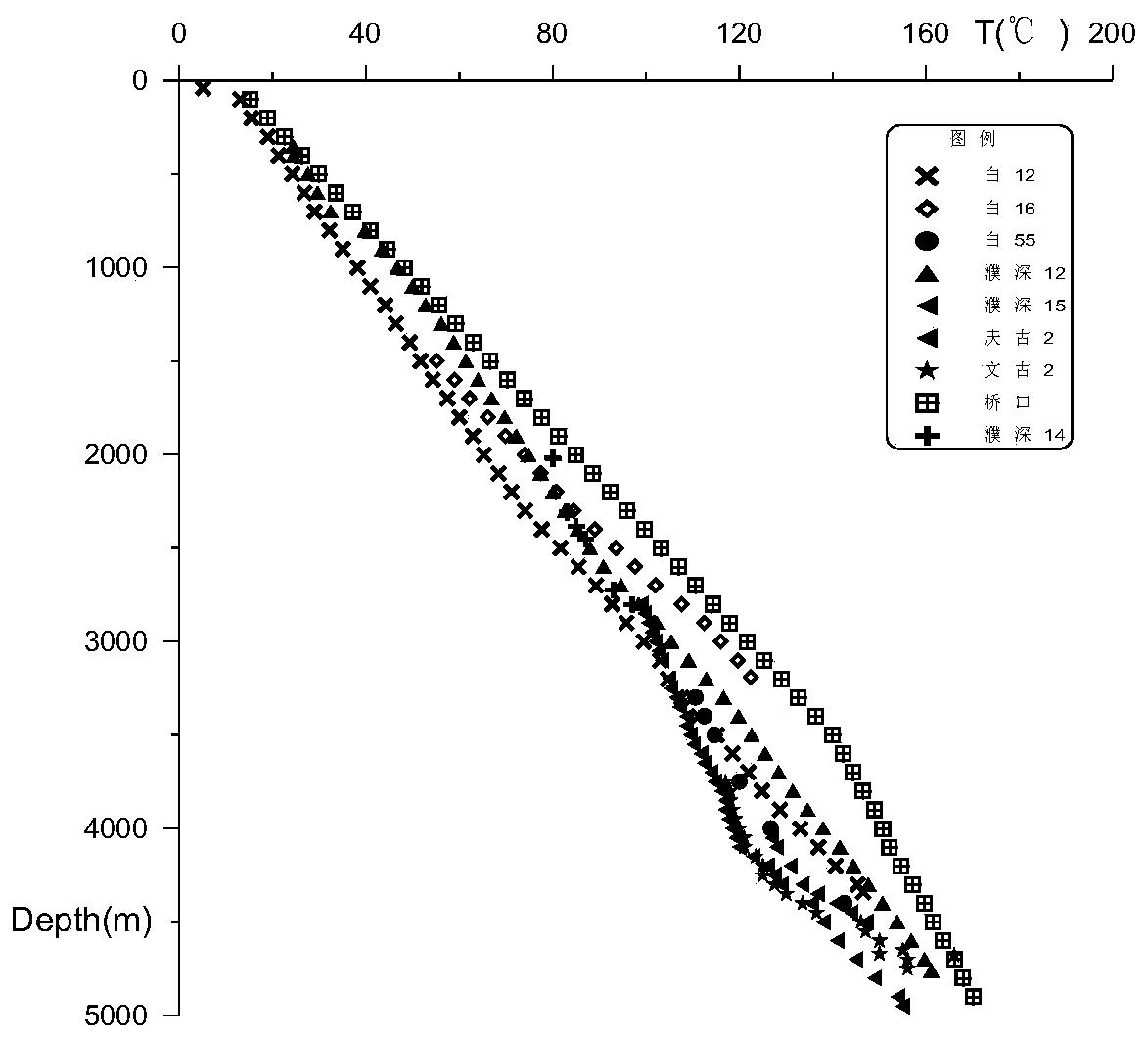
[0030] Embodiment 2, on the basis of embodiment 1, figure 2 It is the continuous temperature measurement data of 9 wells in Dongpu Sag in the embodiment of the present invention. A total of 17 wells in the depression have continuous temperature measurement data, and some well points have oil test temperature measurement data, which can be used as a supplement for temperature control well points. Observing the continuous temperature measurement curve of the well points, it can be found that the temperature of the well points in the depth range of 0-3000m changes uniformly with the depth, and the geothermal gradient of a single well point does not change much. The 17 wells are all divided into 0-3000m, 3000-4300m, 4300m, with three well sections as the geothermal gradient of the well point. The geothermal gradient G in the well section satisfies: G=100*(T 1 -T 0 ) / (H 1 -H 0 ), where H 1 、H 0 is the depth, T 1 , T 0 The temperature corresponding to the corresponding dept...
Embodiment 3
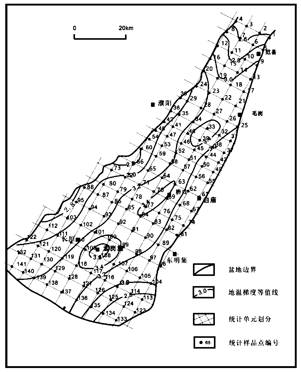
[0031] Example 3: image 3 It is the 0-3000m geothermal gradient contour and geothermal unit division map of the basin according to the embodiment of the present invention. As mentioned above, the geothermal temperature at the 0-3000m well point varies uniformly with depth, that is, the geothermal gradient in the well interval is stable, and interwell interpolation is not affected by structural fluctuations. Therefore, the geothermal gradient distribution map of the well point can be obtained through Kriging interpolation. Specific steps are as follows:
[0032] (1) Divide the geothermal gradient map into relatively uniform grids, and 141 nodes of the grid can be used as virtual wells;
[0033] (2) Import the contour map of the geothermal gradient into Surfer software, select two well points with coordinates, use the plane coordinates as the control, create a posted map, and align the corresponding well points with the contour map of the geothermal gradient, and the geotherma...
PUM
 Abstract
Description
Claims
Application Information
 - R&D
- Intellectual Property
- Life Sciences
- Materials
- Tech Scout
- Unparalleled Data Quality
- Higher Quality Content
- 60% Fewer Hallucinations
Browse by: Latest US Patents, China's latest patents, Technical Efficacy Thesaurus, Application Domain, Technology Topic, Popular Technical Reports.
© 2025 PatSnap. All rights reserved.Legal|Privacy policy|Modern Slavery Act Transparency Statement|Sitemap|About US| Contact US: help@patsnap.com


