Novel topographic map surveying and mapping method

A topographic map and new method technology, applied in the field of surveying, can solve the problems of unobjective description of ground conditions, achieve the effects of saving manpower and material resources, improving safety, and realizing accurate expression

Inactive Publication Date: 2019-05-21
杨永超
View PDF7 Cites 6 Cited by
  • Summary
  • Abstract
  • Description
  • Claims
  • Application Information

AI Technical Summary

Problems solved by technology

[0005] Most of the existing topographic map measurements are completed by artificial height measurement. With the popularization of UAV technology, there are also a small number of UAVs that cooperate with humans to measure. However, UAVs measure at high altitudes, resulting in ground The description of the situation is not objective, only two-dimensional images can be presented, and a large amount of surveying is still required by manpower. Therefore, in order to improve work efficiency, it is necessary to provide a new topographic map measurement method that combines robots with drones, so that Reach the environment that humans cannot reach, and draw topographic maps

Method used


Image

  • Novel topographic map surveying and mapping method
  • Novel topographic map surveying and mapping method

Examples


Embodiment Construction

[0018] The technical solutions in the embodiments of the present invention will be described clearly and in detail below with reference to the drawings in the embodiments of the present invention. The described embodiments are only some of the embodiments of the invention.

[0019] The technical scheme that the present invention solves the problems of the technologies described above is:

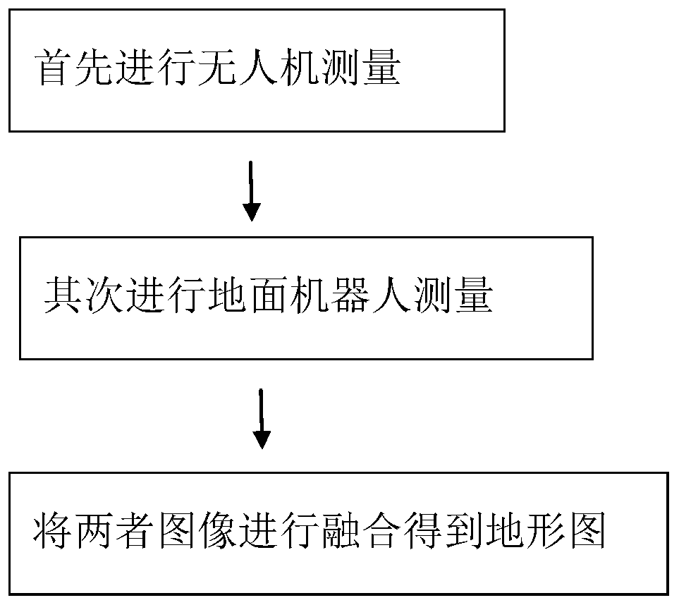
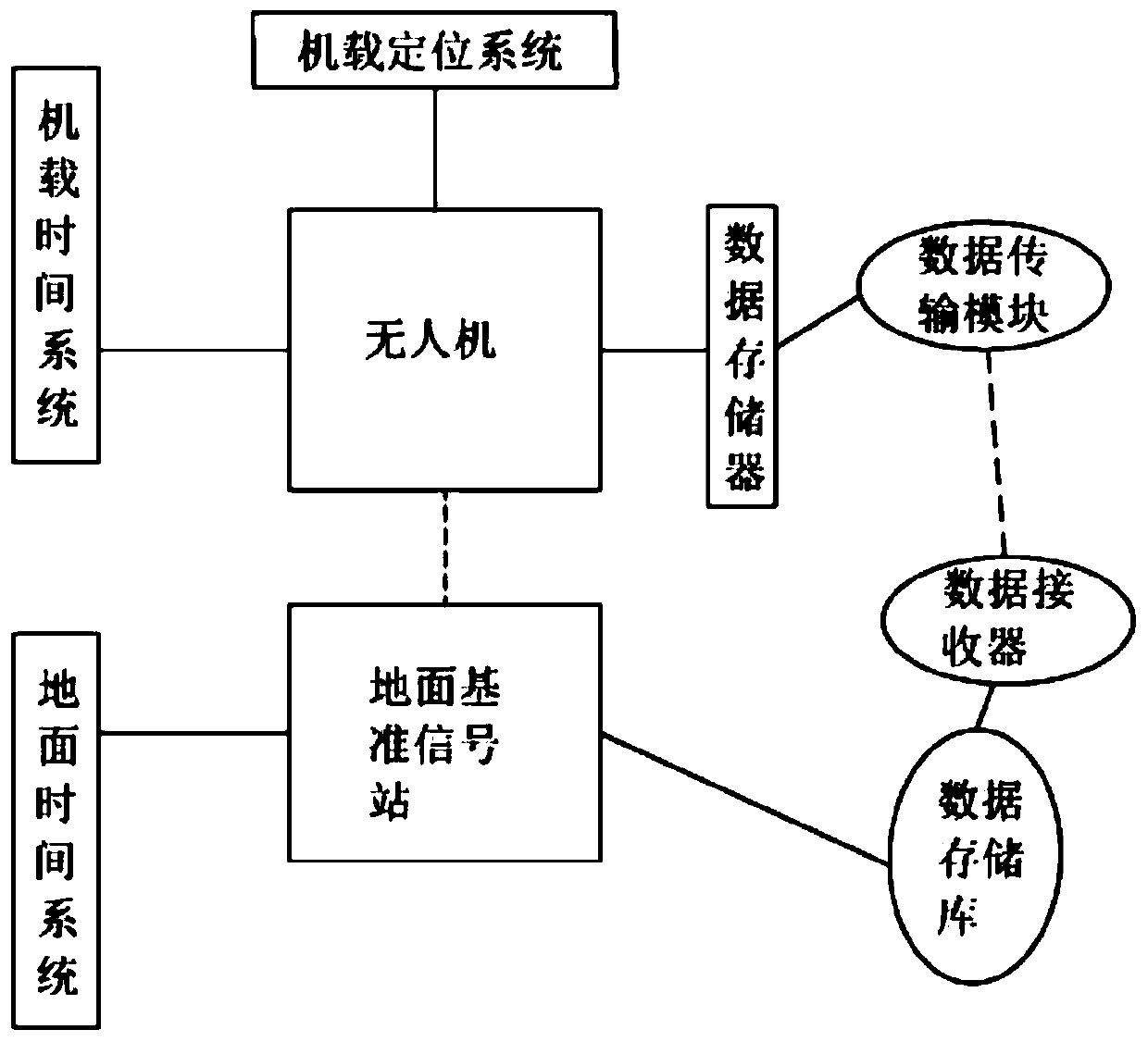
[0020] Such as figure 1 As shown, a new method for surveying and mapping of topographic maps, using ground robots combined with unmanned aerial vehicles for surveying and mapping, and communication between the ground robots and unmanned aerial vehicles, which includes the steps of unmanned aerial vehicle measurement and ground robot measurement , the UAV measurement step includes the following steps:

[0021] Establish a ground reference signal station; calibrate the UAV airborne positioning system with the ground reference signal station; fly the UAV to a fixed point and prepare to start ...


PUM


Abstract

The invention relates to a novel topographic map surveying and mapping method, a ground robot is adopted to be combined with an unmanned aerial vehicle for surveying and mapping, communication connection is conducted between the ground robot and the unmanned aerial vehicle, the method comprises the steps of unmanned aerial vehicle measurement and ground robot measurement, and the unmanned aerial vehicle measurement comprises the following steps that a ground reference signal station is established; an unmanned aerial vehicle airborne positioning system and a ground reference signal station arecalibrated; the unmanned aerial vehicle flies to a fixed point, and measurement is prepared to be started; the unmanned aerial vehicle carries out flying shooting sampling in an up-down fluctuation mode; real-time corresponding storage on the shot sampling data and unmanned aerial vehicle positioning data of the airborne positioning system is performed, and the data is transmitted to a ground reference signal station to obtain an unmanned aerial vehicle measurement image; the measurement of the ground robot is completed, and a ground robot measurement view is obtained; and the unmanned aerialvehicle measurement view is combined with the ground measurement view to obtain a measurement view of the topographic map.

Description

technical field [0001] The invention belongs to the technical field of surveying, in particular to a method for surveying and mapping topographic maps. Background technique [0002] Topographic map refers to the projection map of surface relief and geographical location and shape on the horizontal plane. Specifically, the method of horizontally projecting the objects and landforms on the ground (projecting along the vertical line onto the horizontal plane), and shrinking them onto the drawings according to a certain scale, this kind of map is called a topographic map. [0003] It is quite complicated for people to see topographic maps that reflect the shape and appearance of the earth's surface. Whether it is a mountainous area with undulating topography or a watery plain with dense rivers, lakes and ponds, the various landforms and feature symbols on the map accurately reflect the actual situation on the ground. How are they mapped out? [0004] This begins with clearly ...

Claims


Application Information

Patent Timeline
Patent Type & Authority Applications(China)
IPC IPC(8): G01C11/02B64C39/02
Inventor 杨永超李东辉刘建坡黄继永李玮玮王帅黄述清李东杰
Owner 杨永超
Why Eureka
Try Eureka