Display method and device based on customized emergency map symbol template webgis

A technology of map symbols and display methods, applied in geographic information databases, visual/graphic programming, special data processing applications, etc., can solve the problem of large number of software of the same type, high personnel learning costs and maintenance costs, learning costs and maintenance costs Advanced problems, to achieve the effect of reducing project implementation and operation and maintenance costs, reducing secondary development process links, and reducing learning difficulty

Inactive Publication Date: 2019-05-21
BEIJING GLOBAL SAFETY TECH +1
View PDF6 Cites 3 Cited by
  • Summary
  • Abstract
  • Description
  • Claims
  • Application Information

AI Technical Summary

Problems solved by technology

[0012] (1) Disadvantages of using professional GIS software to edit symbols: you need to master the basic GIS mapping theory and GIS mapping software skills; use commercial version software, such as ArcGIS Desktop, SuperMap Desktop, etc., you need to buy, and the price is very expensive; there are many open source versions, There are many software of the same type, such as QGIS, uDig, etc., and the cost of personnel learning and maintenance is very high; symbol style documents edited by different GIS software cannot be converted to each other
[0013] (2) Disadvantages brought by the use of map service software: the use of commercial version software, such as ArcGIS Server, SuperMap iServer, etc., needs to be purchased, and the price is very expensive; there are many open source versions, and there are many software of the same type, such as GeoServer, MapServer, QGIS Server, etc. have high personnel learning costs and maintenance costs; in actual projects, if there are commercial servers and open source software, it will increase the development and maintenance costs of the project
[0019] (2) The definition of symbol style and the usage of JS SDK API are different in each company, requiring secondary developers to master multiple sets, which is obviously not easy to accumulate;
[0020] (3) The working environment must be in an online Internet network environment

Method used


Image

  • Display method and device based on customized emergency map symbol template webgis
  • Display method and device based on customized emergency map symbol template webgis
  • Display method and device based on customized emergency map symbol template webgis

Examples


Embodiment Construction

[0047] Embodiments of the present invention are described in detail below, examples of which are shown in the drawings, wherein the same or similar reference numerals designate the same or similar elements or elements having the same or similar functions throughout. The embodiments described below by referring to the figures are exemplary and are intended to explain the present invention and should not be construed as limiting the present invention.

[0048] The following describes the webgis display method and device based on the customized emergency map symbol template according to the embodiments of the present invention with reference to the accompanying drawings.

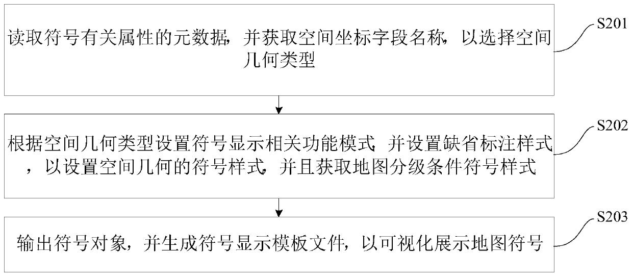
[0049] figure 2 It is a flowchart of a webgis display method based on customized emergency map symbol templates according to an embodiment of the present invention.

[0050] Such as figure 2 As shown, the webgis display method based on the customized emergency map symbol template includes the following step...


PUM


Abstract

The invention discloses a display method and device based on a customized emergency map symbol template webgis, and the method comprises the following steps: reading metadata of symbol related attributes, and obtaining a spatial coordinate field name, so as to select a spatial geometric type; Setting a symbol display related function mode according to the spatial geometric type, setting a defaultannotation mode to set a symbol mode of the spatial geometric type, and obtaining a map grading condition symbol mode; And outputting the symbol object, and generating a symbol display template file to visually display the map symbols. According to the method, standard map symbol display is used for the emergency industry, a unified self-defined symbol style template is formulated, secondary development process links are reduced, the purchase cost of a project is reduced, the learning difficulty of secondary developers is reduced, the implementation and operation and maintenance cost of the project is reduced, the applicability is high, the use cost is greatly reduced, and the method is simple and easy to implement.

Description

technical field [0001] The invention relates to the technical field of emergency map symbol display, in particular to a webgis display method and device based on a customized emergency map symbol template. Background technique [0002] At present, there are more than 70 GIS-related symbols in the "Specifications for Emergency Plotting Symbols" standard. Each project requires GIS personnel to perform complex and cumbersome symbol configuration. Different GIS software involves commercial software: ArcGIS, SuperMap, open source UDig, QGIS, GeoServer, etc. have different symbol configuration methods; when the software is running online, after the symbol configuration is modified, the map service needs to be restarted to take effect; each map service software has a corresponding A set of WebGIS SDK Api requires secondary developers to master and learn; many different types of symbols have similar display functions, and can only be developed by WebGIS secondary developers who unde...

Claims


Application Information

Patent Timeline
Patent Type & Authority Applications(China)
IPC IPC(8): G06F8/34G06F8/38G06F16/29
CPCG06F8/34G06F8/38G06F16/29G06F16/587
Inventor 袁宏永陈建国薛元宏黄全义苏国锋陈涛孙占辉杨秀中
Owner BEIJING GLOBAL SAFETY TECH
Why Eureka
Try Eureka