Unmanned aerial vehicle image road damage assessment method based on vector guidance

A technology of drones and roads, applied in image analysis, image data processing, instruments, etc., can solve the problems of low work efficiency, insufficient objective results, and low degree of automation, and achieve fast evaluation, objective evaluation results, and automation high degree of effect

Active Publication Date: 2019-05-21
WUHAN UNIV
View PDF6 Cites 9 Cited by
  • Summary
  • Abstract
  • Description
  • Claims
  • Application Information

AI Technical Summary

Problems solved by technology

[0008] Aiming at the problems of low degree of automation, low work efficiency, and unobjective results in the background technology, the present invention provides a road damage assessment method based on vector-guided UAV images

Method used


Image

  • Unmanned aerial vehicle image road damage assessment method based on vector guidance
  • Unmanned aerial vehicle image road damage assessment method based on vector guidance
  • Unmanned aerial vehicle image road damage assessment method based on vector guidance

Examples


Embodiment Construction

[0064] In order to facilitate those of ordinary skill in the art to understand and implement the present invention, the present invention will be further described in detail below in conjunction with the accompanying drawings and embodiments:

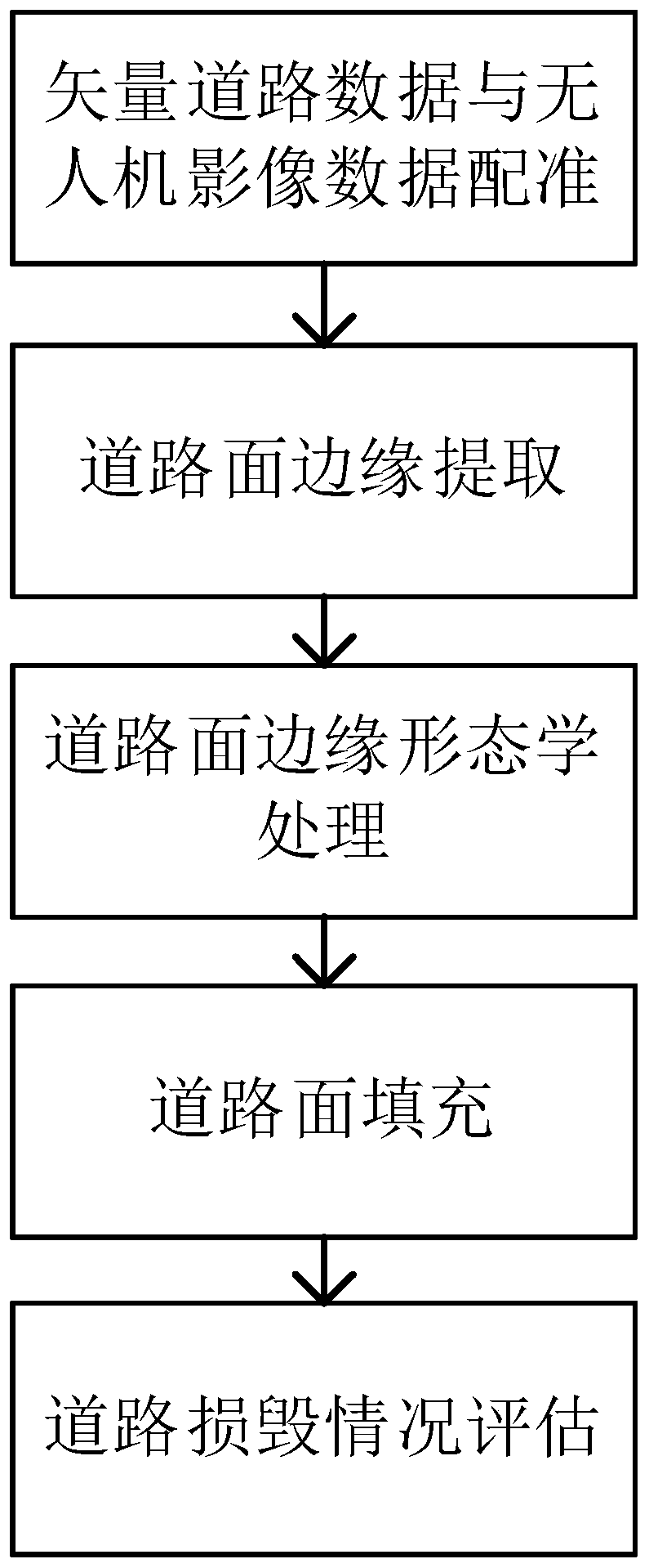
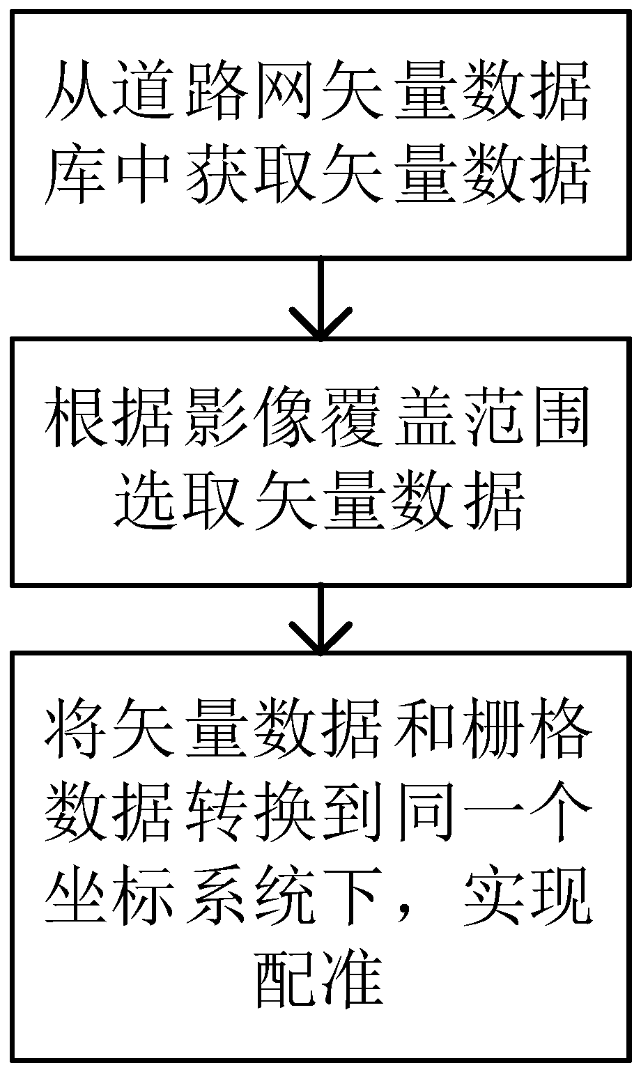
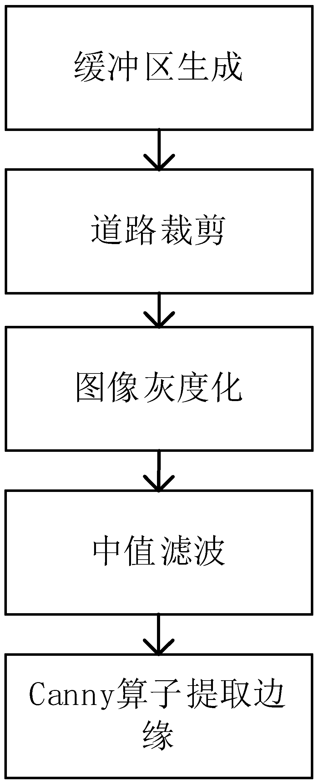
[0065] figure 1 Shows the overall flow of the real-time method of the present invention: use the existing road network vector data to register the collected UAV image data with it, use the edge detection operator to obtain the edge information of the grayscale image, and then use Morphological algorithms connect and refine the edges. Then use vector data to generate seed points, fill the road surface with flood water from the seed points, generate multiple road surfaces, and finally count the number and area of ​​road surfaces, compare them with the area of ​​the complete road, and achieve objective road damage Evaluation. It should be noted that all steps after registration can be completed automatically with the help of an electronic c...


PUM


Abstract

The invention provides an unmanned aerial vehicle image road damage assessment method based on vector guidance, and the method comprises the steps: registering the collected unmanned aerial vehicle image data by using the existing road network vector data, and cutting an image by using a registered road as a buffer region. And edge information of the image is obtained by using an edge detection operator, and then connection and refinement processing are performed on the edges by using a morphological algorithm; and then generating seed points by using the vector data, and carrying out floodingfilling on the road surfaces from the seed points to sequentially generate a plurality of road surfaces; and finally, counting the number and area of road surfaces, and comparing the number and areawith the area of a complete road to realize objective assessment of road damage.

Description

Technical field [0001] The invention relates to a road damage evaluation method for UAV images, in particular to a road damage evaluation method for UAV images based on vector guidance, belonging to the technical field of road disaster evaluation. Background technique [0002] As the main mode of transportation, road traffic carries most of the tasks of personnel movement and cargo transportation, and plays a vital role in the development of the national economy. However, roads are often damaged by natural disasters such as earthquakes, floods, and mudslides, causing severe road damage and great losses to the national economy. After the road is damaged, the highway management department needs to do a lot of investigations along the road to assess the degree of road damage. [0003] Traditional road damage assessment mostly uses manual on-site mapping, which is time-consuming and labor-intensive, and cannot quickly assess the damage of the road. Especially after a major disaster o...

Claims


Application Information

Patent Timeline
Patent Type & Authority Applications(China)
IPC IPC(8): G06T7/00G06T7/13G06T7/187G06T7/30
Inventor 陈能成刘晓林王超杜文英
Owner WUHAN UNIV
Why Eureka
Try Eureka