Aeromagnetic survey and ground magnetic survey-combined high-precision magnetic survey method

A high-precision, airborne magnetic survey technology, applied in the field of magnetic prospecting, can solve the problems of high flying height of fixed-wing drones, limited measurement area in one dispatch, poor magnetic body prospecting effect, etc., so as to reduce the area of ​​artificial magnetic survey , flexible and convenient operation form, and strong ability in complex terrain conditions

Inactive Publication Date: 2019-06-18
BEIJING EXPLORATION RESOURCES TECH CO LTD
View PDF9 Cites 0 Cited by
  • Summary
  • Abstract
  • Description
  • Claims
  • Application Information

AI Technical Summary

Problems solved by technology

Although the threshold for using the aeromagnetic method has been greatly reduced, there are still some problems: (1) Fixed-wing UAVs have certain requirements for take-off and landing sites, and the flying speed is fast, so it is difficult to fly at altitudes such as terrain following during the flight process, and Relatively poor measurement accuracy
(2) The flying height of the fixed-wing UAV is relatively high, and the exploration effect on the shallow magnetic body is not good
(3) Rotary-wing UAVs generally have a small load, short battery life, and a limited measurement area for one dispatch. The efficiency is not as good as that of fixed-wing UAVs. Its accuracy is higher than that of fixed-wing UAVs, but it is still lower than that of ground-based artificial magnetic surveys. the accuracy of

Method used


Image

  • Aeromagnetic survey and ground magnetic survey-combined high-precision magnetic survey method

Examples


Embodiment

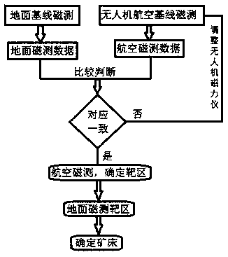
[0023] See figure 1 , A combined air-to-ground high-precision magnetic survey method, which uses a combination of UAV aerial magnetic survey and ground artificial magnetic survey;

[0024] Step 1: Delineate a ground measurement baseline on the ground of the exploration area, and manually perform magnetic surveys along the measurement baseline to obtain ground measurement data;

[0025] Step 2: Use the drone to perform magnetic survey along the measurement baseline in the air to obtain the aerial magnetic survey data. The aerial magnetic survey data is compared with the ground magnetic survey data to make corrections; after the correction, the drone is used to quickly perform the entire exploration area Magnetic survey scan, delineate the preliminary mine target area;

[0026] Step three, the staff conducts magnetic survey on the mine target area on the ground, and finally determines the deposit.

[0027] Further, in step 1, two ground measurement baselines are arranged on the ground ...


PUM


Abstract

The invention discloses an aeromagnetic survey and ground magnetic survey-combined high-precision magnetic survey method. According to the method, unmanned aerial vehicle aeromagnetic survey and ground manual magnetic survey are combined. The method includes the following steps that: step 1, a ground measurement baseline is delineated in the ground of an exploration area, manual operation is carried out to perform magnetic survey along the measurement baseline, so that ground measurement data are obtained; step 2, an unmanned aerial vehicle is used to perform magnetic survey along the measurement baseline in the air so as to obtain aeromagnetic survey data, and comparative judgment is performed on the aeromagnetic survey data and the ground magnetic survey data, so that the aeromagnetic survey data are corrected; after the aeromagnetic survey data are corrected, the unmanned aerial vehicle is adopted to perform rapid magnetic survey scanning on the entire exploration area so as to delineate a preliminary mine target area; and step 3, a worker conducts magnetic survey on the mine target area so as to finally confirm a deposit. According to the aeromagnetic survey and ground survey-combined high-precision magnetic survey method of the invention, an aeromagnetic survey and ground magnetic survey combined mode is adopted; the ground measurement data can be adopted to correct the aeromagnetic survey data, and therefore, the accuracy of the aeromagnetic survey can be ensured, and measurement precision is high.

Description

Technical field [0001] The invention belongs to the technical field of magnetic exploration, and specifically relates to an air-ground combined high-precision magnetic survey method. Background technique [0002] At present, many types of metal deposits can cause local anomalies in the earth's magnetic field. Such deposits can be delineated by measuring the changes in the total earth's magnetic field caused by the magnetization of rocks and soils in different regions. The discovery of many mineral deposits at home and abroad started from the magnetic anomaly target area delineated by magnetic measurement. [0003] Magnetic measurement can be divided into aerial magnetic measurement and terrestrial magnetic measurement. (1) Ground magnetic measurement generally involves measuring personnel carrying instruments along the preset survey line and measuring points point by point. This method has high accuracy but efficiency Low, high cost, especially when the terrain is undulating or lo...

Claims


Application Information

Patent Timeline
Patent Type & Authority Applications(China)
IPC IPC(8): G01V3/08
Inventor 王扬州牛云飞郭生凯邢涛
Owner BEIJING EXPLORATION RESOURCES TECH CO LTD
Why Eureka
Try Eureka