A dynamic optimization method for a geotechnical engineering investigation scheme

A technology of dynamic optimization and geotechnical engineering, applied in special data processing applications, instruments, electrical digital data processing, etc., can solve problems such as not well satisfying geotechnical engineering characteristics, insufficient consideration of geotechnical engineering design schemes, etc. Achieve the effects of reducing survey costs, improving practicability, and improving feasibility

Inactive Publication Date: 2019-06-25
CHINA UNIV OF GEOSCIENCES (WUHAN)
View PDF9 Cites 16 Cited by
  • Summary
  • Abstract
  • Description
  • Claims
  • Application Information

AI Technical Summary

Benefits of technology

This patented technology allows for better understanding about buildings by analyzing their structural features during construction or other activities. By combining these models together into one framework, researchers are able to make informed decisions based upon factors like environmental impact, site selection criteria, etc., making more efficient exploration efforts possible while reducing costs associated therewith.

Problems solved by technology

Technological Problem: Current techniques used by researchers often require detailed analysis or simulations during exploration campaigns due to their limitations such as long wait times and complex calculations required before they reach an objective evaluation level. Additionally, current forms of measurement tools may lack accuracy when analyzing large amounts of soil properties over short periods of time (such as seasonality).

Method used


Image

  • A dynamic optimization method for a geotechnical engineering investigation scheme
  • A dynamic optimization method for a geotechnical engineering investigation scheme

Examples


Embodiment Construction

[0029] In order to have a clearer understanding of the technical features, purposes and effects of the present invention, the specific implementation manners of the present invention will now be described in detail with reference to the accompanying drawings.

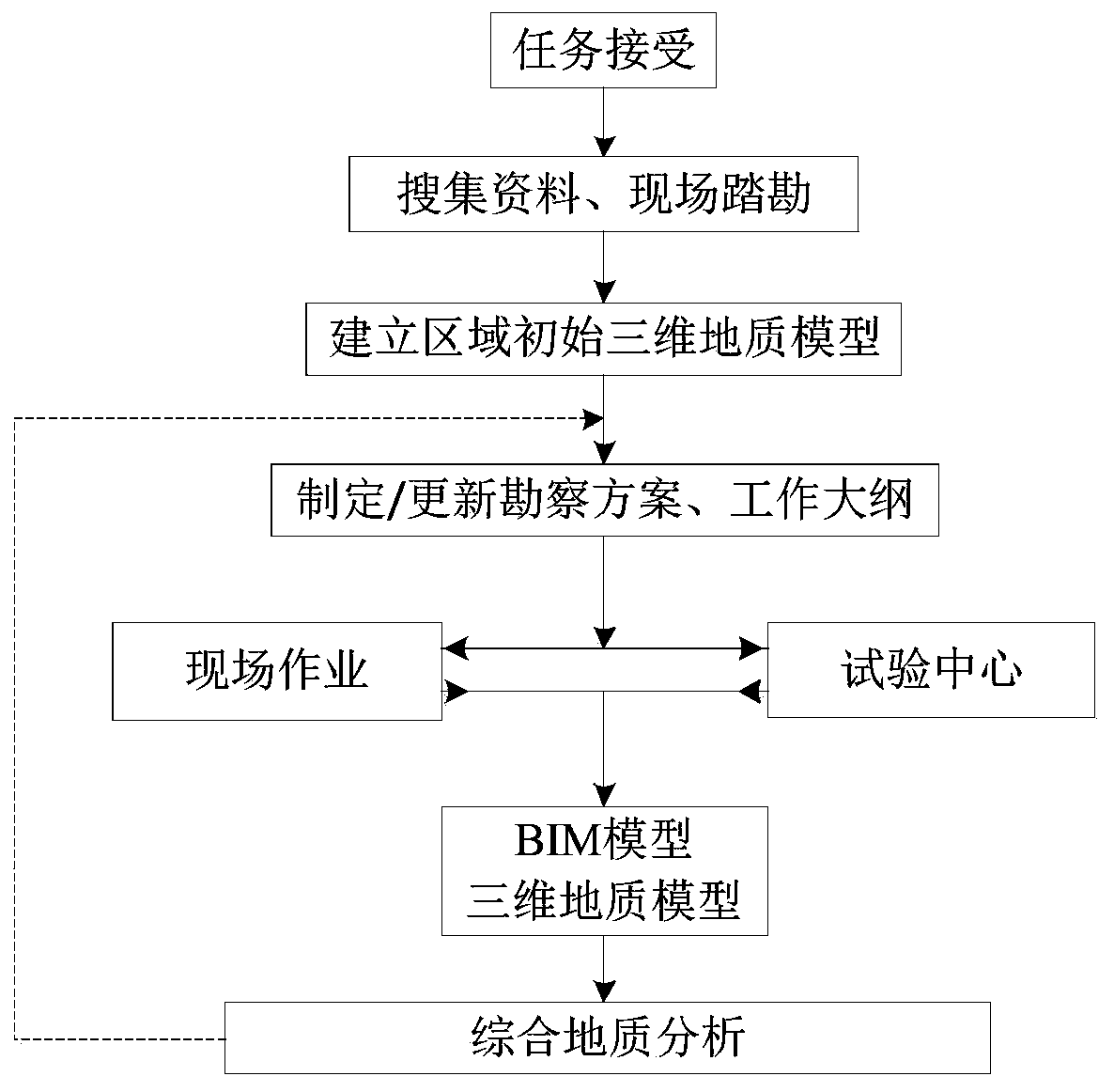
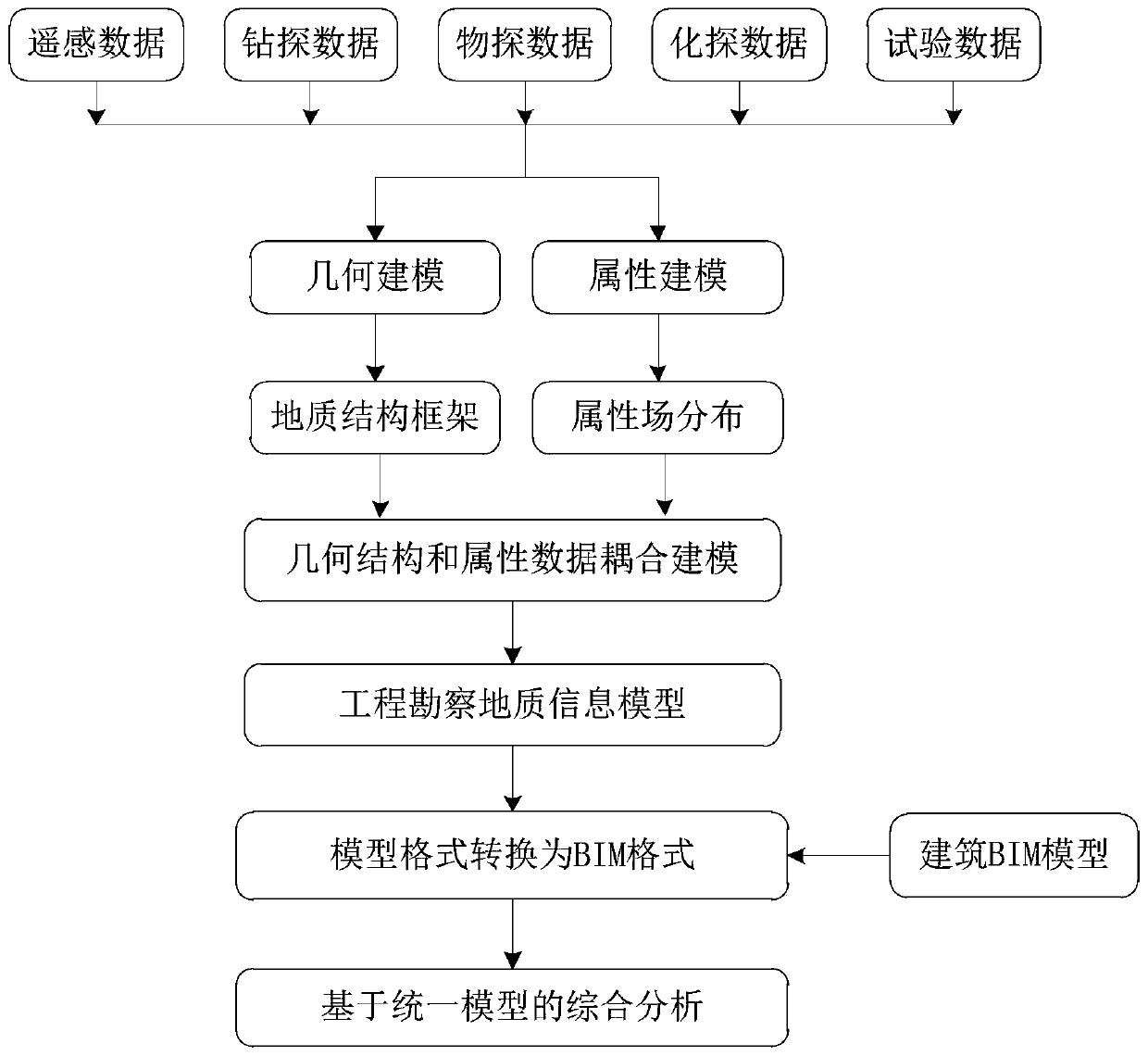
[0030] refer to figure 1 and figure 2 ,in figure 1 It is the flow chart of the optimization design of the survey plan of the present invention, figure 2 It is a flow chart of the geological information coupling modeling process of the present invention and its integration with the building BIM model. The dynamic optimization method of the geotechnical engineering investigation plan of the present invention comprises the following steps:

[0031] S1. After accepting the survey task, use the existing data (basic geological map and corresponding contour lines) and the results of on-site survey to establish the initial three-dimensional geological information model of the survey area.

[0032] S2. Integrate the 3D geo...


PUM


Abstract

The current design and optimization of the existing investigation scheme mainly consider technical specifications and investigation cost, especially control of the investigation work cost, the consideration of the geotechnical engineering design scheme is insufficient, and the achievement of the investigation work cannot well meet the requirements of various geotechnical engineering characteristics related to the proposed engineering. The invention provides a dynamic optimization method for a geotechnical engineering investigation scheme. Based on the three-dimensional visualization technologyand with the building information model of geotechnical engineering as a reference, dynamically generated engineering investigation information is integrated into the building information model, theinvestigation key points and needs of the next stage are analyzed in combination with the building model and the geological information model, and an investigation scheme is optimally designed. According to the method, the requirements of a building on the geological environment can be fully considered in the establishment of a common intervention scheme of related personnel for engineering investigation, the feasibility of the investigation scheme and the usability of an investigation result are improved, and the investigation cost is reduced.

Description


Claims


Application Information

Patent Timeline
Owner CHINA UNIV OF GEOSCIENCES (WUHAN)
Why Eureka
Try Eureka