
Urban greenbelt landscape evaluation method and device, storage medium and terminal equipment

An evaluation method and landscape technology, applied in the direction of instruments, character and pattern recognition, computer parts, etc., can solve the problem of lack of urban green space landscape evaluation methods and other problems

Inactive Publication Date: 2019-06-28
GUANGZHOU URBAN PLANNING & DESIGN SURVEY RES INST
View PDF4 Cites 16 Cited by
  • Summary
  • Abstract
  • Description
  • Claims
  • Application Information

AI Technical Summary

Problems solved by technology

[0004] The present invention provides an evaluation method, device, storage medium and terminal equipment for urban green space landscape, aiming to solve the problem of lack of evaluation method for urban green space landscape at present

Method used


Image

  • Urban greenbelt landscape evaluation method and device, storage medium and terminal equipment
  • Urban greenbelt landscape evaluation method and device, storage medium and terminal equipment
  • Urban greenbelt landscape evaluation method and device, storage medium and terminal equipment

Examples


Embodiment Construction

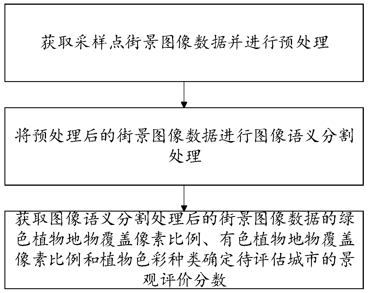
[0055] Such as figure 1 Shown, the invention provides a kind of urban green space landscape evaluation method, comprising:

[0056] Obtain the street view image data of sampling points and perform preprocessing;

[0057] Perform image semantic segmentation processing on the preprocessed street view image data;

[0058] Obtain the pixel coverage ratio of green plants and features, the pixel coverage ratio of colored plants and features in the street view image data processed by image semantic segmentation, and determine the landscape evaluation score of the city to be evaluated.

[0059] Compared with the prior art, the present invention discloses a method for evaluating urban green space landscape, which acquires street view image data, and obtains the proportion of green plants and features covered by pixels in the street view image data after image semantic segmentation processing, colored plant The pixel ratio of ground object coverage and the type of plant color determin...


PUM


Abstract

The invention discloses an urban greenbelt landscape evaluation method and device, a storage medium and terminal equipment. The method comprises the following steps: acquiring sampling point streetscape image data and preprocessing the sampling point streetscape image data; performing image semantic segmentation processing on the preprocessed street view image data; and obtaining a green plant ground object coverage pixel proportion, a colored plant ground object coverage pixel proportion and a plant color type in the streetscape image data after image semantic segmentation processing, and determining a landscape evaluation score of the to-be-evaluated city. Streetscape images are used for replacing streetscape three-dimensional images which need to be obtained through on-site investigation, processing the streetscape image data to obtain a colored plant ground object coverage pixel proportion and a plant color type; the urban green space landscape evaluation method achieves analysis of colored plant ground objects, solves the problems that green space landscape evaluation data are difficult to obtain and data analysis is not comprehensive enough, and can automatically collect landscape three-dimensional images and conduct unified processing and system analysis.

Description

technical field [0001] The invention relates to the technical field of urban environment monitoring, in particular to a method, device, storage medium and terminal equipment for urban green space landscape evaluation. Background technique [0002] Urban green space plays an important role in improving air, water and soil quality, absorbing and reducing carbon dioxide and various pollutants, alleviating urban heat island and reducing rainwater runoff and other ecological functions. On the other hand, high-quality urban green space plays an important role in shaping the image of the city and improving the happiness of urban residents. For this reason, it is necessary to carry out scientific and reasonable evaluation of the landscape benefits of urban green space, so as to continuously improve the landscape quality of urban green space and exert greater social benefits. However, the current evaluation of urban green space is mainly aimed at the evaluation of green space, and t...

Claims


Application Information

Patent Timeline
IPC IPC(8): G06K9/00G06K9/34
Inventor 王烨周岱霖廖远涛刘云亚滕腾吴丽娟
Owner GUANGZHOU URBAN PLANNING & DESIGN SURVEY RES INST
Learn More