Method, system and device for constructing indoor navigation network

A technology of indoor navigation and construction method, which is applied in the direction of navigation, measuring device, surveying and navigation, etc., can solve the problems of not being able to provide indoor navigation network structure, and achieve the effect of accurate reconstruction, high precision and practicability

Active Publication Date: 2021-03-30
SHENZHEN UNIV
View PDF4 Cites 0 Cited by
  • Summary
  • Abstract
  • Description
  • Claims
  • Application Information

AI Technical Summary

Problems solved by technology

[0004] In view of the deficiencies in the above-mentioned prior art, the purpose of the present invention is to provide users with a method, system and device for building an indoor navigation network based on the BIM model, to overcome the inability to provide a more accurate navigation network in the prior art. Defects of Indoor Navigation Network Structure

Method used


Image

  • Method, system and device for constructing indoor navigation network
  • Method, system and device for constructing indoor navigation network
  • Method, system and device for constructing indoor navigation network

Examples


Embodiment 1

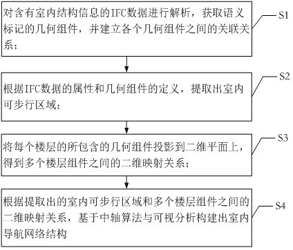
[0048] The first embodiment provided by the present invention is a method for building an indoor navigation network based on a BIM model, such as figure 1 shown, including:

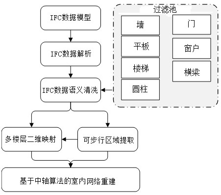
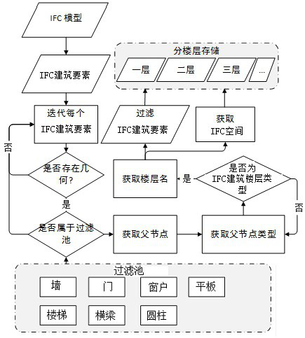
[0049] Step S1, analyzing the IFC data containing indoor structure information, obtaining semantically marked geometric components, and establishing associations between various geometric components.

[0050]Obtain the IFC data containing information about the interior layout to be carried out, import the data into the parser based on the IFC standard for analysis, construct the parsed data, extract the geometric information contained in the parsed model, and obtain the semantically marked geometry based on the geometric information Components, and establish the association information between geometric components.

[0051] Step S2, extract the indoor walkable area according to the attributes of the IFC data and the definition of the geometric components.

[0052] The walkable area plays an important ro...

Embodiment 2

[0088] The second embodiment provided by the present invention is a system for building an indoor navigation network based on a BIM model, such as Image 6 mentioned, including:

[0089] The data parsing module 610 is used for parsing the IFC data containing indoor structure information, obtaining semantically marked geometric components, and establishing associations between various geometric components; its function is as described in step S1.

[0090] The walkable area extraction module 620 is used to extract the indoor walkable area according to the attributes of the IFC data and the definition of the geometric components; its function is as described in step S2.

[0091] The two-dimensional mapping module 630 is configured to project the geometric components contained in each floor onto a two-dimensional plane to obtain the two-dimensional mapping relationship between multiple floor components; its function is as described in step S3.

[0092] The network construction mo...

Embodiment 3

[0096] The third embodiment provided by the present invention is a device for building an indoor navigation network based on a BIM model, which includes: a processor, a memory, and a system based on The construction control program of the indoor navigation network of the BIM model, wherein the construction control program of the indoor navigation network based on the BIM model is executed by the processor to implement the following steps:

[0097] Analyze the IFC data containing indoor structure information, obtain the geometric components of the semantic mark, and establish the relationship between each geometric component;

[0098] According to the attributes of IFC data and the definition of geometric components, indoor walkable areas are extracted;

[0099] Project the geometric components contained in each floor onto a two-dimensional plane to obtain a two-dimensional mapping relationship between multiple floor components;

[0100] According to the two-dimensional mappin...


PUM


Abstract

The invention provides an indoor navigation network constructing method, system and device. IFC data containing indoor structure information is parsed to establish an association relationship betweengeometric components. An indoor walkable area is extracted, and geometric components included by each floor are projected onto a two-dimensional plane to acquire a two-dimensional mapping relationshipbetween a number of floor components. Based on the extracted two-dimensional mapping relationship between the indoor walkable area and a number of floor components and based on an axis algorithm andvisual analysis, an indoor navigation network structure is constructed. According to the invention, the method realizes indoor network reconstruction based on an IFC standard model, which fully utilizes detailed geometric, semantic and component hierarchical relationship in the IFC model; an indoor topology is accurate reconstructed; a two-dimensional and three-dimensional integrated indoor topology model is constructed; and a high-precision and practical indoor navigation network is provided, which is convenient for indoor navigation.

Description

technical field [0001] The present invention relates to the technical field of indoor navigation, in particular to a method, system and device for building an indoor navigation network based on a BIM model. Background technique [0002] With the increasing complexity of the indoor environment and the increasing demand for indoor applications, the indoor navigation network has become an important data basis for supporting current indoor applications, and it is also one of the most challenging research directions for current indoor applications. High-precision indoor navigation needs to rely on high-precision indoor geometric and semantic networks. At present, 3D scanning technology can quickly obtain complex geometric shapes outdoors, and then realize data segmentation and semantic modeling. However, the structure of the indoor environment is complex, and it is difficult to accurately obtain the indoor semantic 3D model through simple geometric modeling. Therefore, a large n...

Claims


Application Information

Patent Timeline
Patent Type & Authority Patents(China)
IPC IPC(8): G01C21/20
CPCG01C21/206
Inventor 王伟玺汤圣君原志路
Owner SHENZHEN UNIV
Why Eureka
Try Eureka