Geological outcrop rapid three-dimensional reconstruction method based on motion recovery structure

A motion recovery structure, three-dimensional reconstruction technology, applied in the field of geological information, can solve problems such as inapplicable large-scale geological three-dimensional reconstruction, and achieve the effects of low cost, simplified workflow and wide range

Inactive Publication Date: 2019-07-12
CHINA UNIV OF GEOSCIENCES (BEIJING)
View PDF3 Cites 3 Cited by
  • Summary
  • Abstract
  • Description
  • Claims
  • Application Information

AI Technical Summary

Problems solved by technology

However, it is still difficult to use Kinect to reconstruct large scenes and long-distance 3D geological models.
[0008] The 3D model generated by kinect is lim

Method used


Image

  • Geological outcrop rapid three-dimensional reconstruction method based on motion recovery structure
  • Geological outcrop rapid three-dimensional reconstruction method based on motion recovery structure
  • Geological outcrop rapid three-dimensional reconstruction method based on motion recovery structure

Examples


Embodiment 1

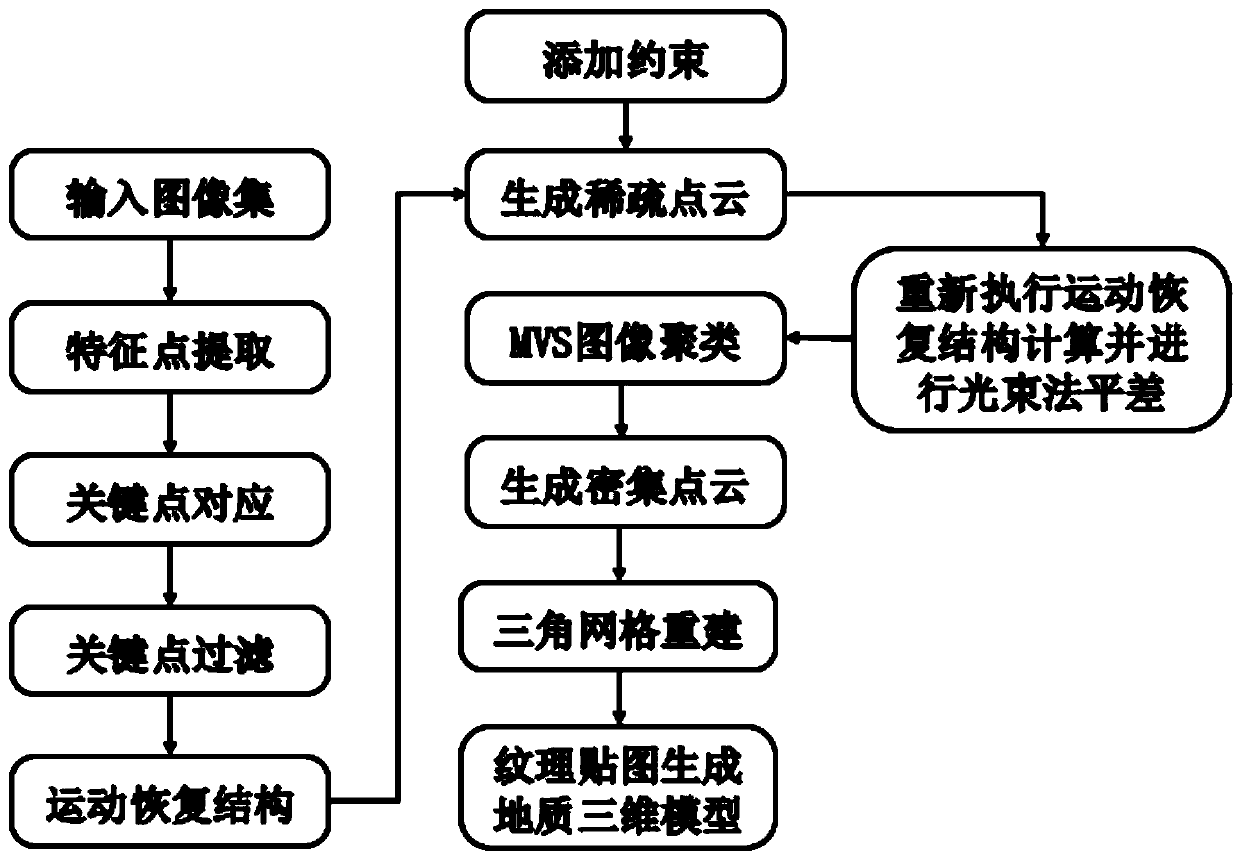
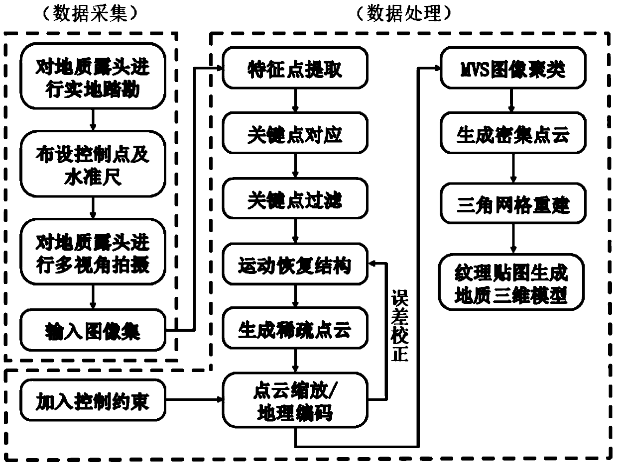
[0104] (1) Before the geological 3D model is reconstructed, a certain number of control points or leveling rods need to be arranged around the model.

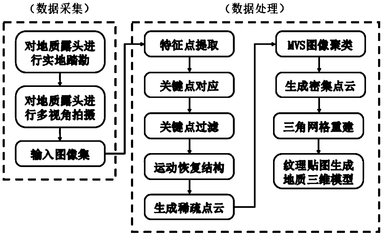
[0105] (2) Multi-angle shooting of 3D geological outcrops, at least 3 pictures are required for each geological surface. Depending on the size of the scene, take photos with over 50% overlap. Such as Figure 6 shown.

[0106] (3) Image feature extraction, such as Figure 7 shown.

[0107] (4) Based on the motion recovery structure algorithm, the attitude relationship between the camera and the geological outcrop is constructed at the same time, and the sparse 3D point cloud is obtained, such as Figure 8 shown.

[0108] (5) Add control point or length distance information to scale the model size. Such as Figure 9 .

[0109] (6) Recalculate using beam adjustment and motion recovery structure to reduce the error between the sparse point cloud and the actual model.

[0110] (7) Using a multi-view clustering algorithm to ...

Embodiment 2

[0114] Obtain high-precision RTK information for 3D reconstruction while shooting objects:

[0115] (1) The camera obtains the coordinate information of the shooting point while shooting the object, such as Figure 13 .

[0116] (2) Before locating feature points, input GPS information for image locating, combined with google earth to locate the specific position of the shooting point in the earth, such as Figure 14 .

[0117](3) Extract the feature points of the input image and use the method of motion recovery structure to obtain the sparse point cloud of the 3D scene. At this time, the size of the 3D scene is controlled by proportional constraints, such as Figure 15 .

[0118] (4) Through the multi-view clustering algorithm MVS, the dense point cloud of the target 3D scene is constructed to obtain outcrop spatial information, such as Figure 16 .

[0119] (5) Poisson grid reconstruction to generate structured three-dimensional space data, such as Figure 17 .

[01...

Embodiment 3

[0122] Based on the workflow of the present invention, the camera is mounted on the UAV to generate a digital three-dimensional model of the open-pit mine, and the digital elevation information can be quickly obtained to analyze and study the dynamic reserves of the open-pit mine.

[0123] Such as Figure 19 The generated digital 3D model of Beijing Wake Iron Mine can be processed and analyzed later, and a variety of geological data can be generated according to different geological applications, such as Figure 20 3D digital elevation model. It has a broad application prospect market in mine reserve changes and environmental monitoring.


PUM


Abstract

The invention relates to the technical field of geological information, in particular to a geological outcrop rapid three-dimensional reconstruction method based on a motion recovery structure, whichcomprises the following steps: arranging control points and measuring rods for geological outcrop and geological phenomena, shooting at least more than three pictures for each geological outcrop surface, and restoring the size of a real three-dimensional geological outcrop model; after corresponding proportional constraint information is added, optimizing and adjusting the attitude position of thecamera by adopting light beam adjustment; after the accurate sparse point cloud is obtained, using an MVS algorithm to construct the dense three-dimensional point cloud of the geological outcrop; after the dense point cloud is obtained, constructing a point cloud triangulation network through Poisson reconstruction, and obtaining a geological three-dimensional model; attaching corresponding geological outcrop texture information to the three-dimensional model, and restoring a real geological three-dimensional model landscape. The three-dimensional model generated by the method can be used forgeological structure extraction, attitude element measurement and formation unit division, and a highly realistic geological three-dimensional model can be generated by combining a 3d printing technology.

Description

technical field [0001] The invention relates to the technical field of geological information, in particular to a fast three-dimensional reconstruction method for geological outcrops based on motion restoration structures. Background technique [0002] At present, there are generally several methods for reconstructing 3D geological outcrop models: [0003] Lidar, also known as lidar, is an optical remote sensing technology that reconstructs a 3D model by irradiating a beam of light, usually a pulsed laser, to a target to obtain parameters such as the distance of the measured target. Divided into airborne lidar and ground lidar. This technology can obtain the 3D point cloud model of geological outcrops in real time, and is one of the commonly used technologies for constructing 3D models in geological engineering. [0004] Although lidar is a method to obtain 3D models of geological outcrops, the cost of equipment and instruments is relatively high. In the current situation,...

Claims


Application Information

Patent Timeline
IPC IPC(8): G06T17/05G06T17/20
CPCG06T17/05G06T17/20
Inventor 陈建平王天乐郑彦威
Owner CHINA UNIV OF GEOSCIENCES (BEIJING)
Why Eureka
Try Eureka