Ground shelter elevation measurement method based on satellite-borne stereoscopic optical image

An optical image and measurement method technology, applied in the field of remote sensing, can solve problems such as increasing work costs and reducing work efficiency, and achieve the effects of improving production efficiency, reducing work costs, and ensuring accuracy and reliability.

Active Publication Date: 2019-07-19
WUHAN UNIV
View PDF4 Cites 4 Cited by
  • Summary
  • Abstract
  • Description
  • Claims
  • Application Information

AI Technical Summary

Problems solved by technology

Traditionally, field surveyors can use surveying and mapping equipment to measure occlusion angles for availability analysis. However, the areas of interest may be scattered all over the world. If field surveyors conduct on-site measurement, it will greatly reduce work efficiency and increase work costs.

Method used


Image

  • Ground shelter elevation measurement method based on satellite-borne stereoscopic optical image
  • Ground shelter elevation measurement method based on satellite-borne stereoscopic optical image
  • Ground shelter elevation measurement method based on satellite-borne stereoscopic optical image

Examples


Embodiment Construction

[0021] In order to facilitate those of ordinary skill in the art to understand and implement the present invention, the present invention will be described in further detail below in conjunction with the accompanying drawings and embodiments. It should be understood that the implementation examples described here are only used to illustrate and explain the present invention, and are not intended to limit this invention.

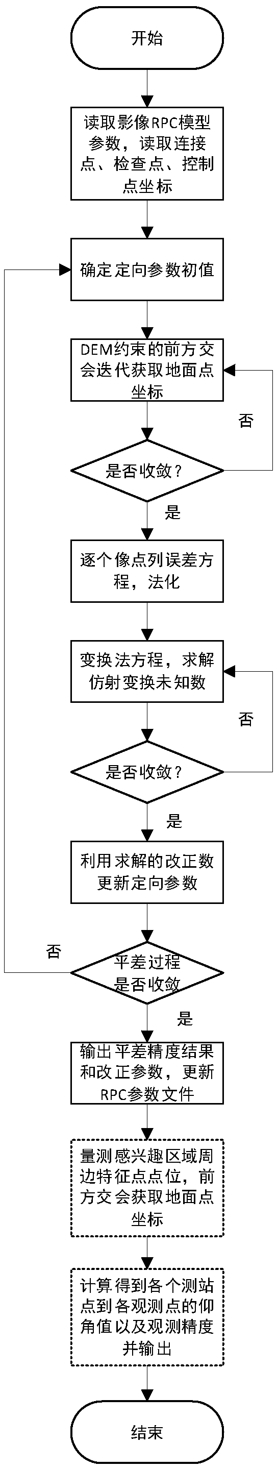
[0022] please see figure 1 A method for measuring the elevation angle of a ground obstruction based on a spaceborne stereoscopic optical image provided by the present invention comprises the following steps:

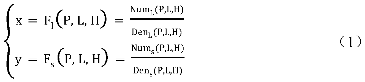
[0023] Step 1: Read the spaceborne optical stereoscopic image, use matching technology or manual collection, etc. to select the same-named point in the overlapping area of ​​adjacent spaceborne optical stereoscopic image as the connection point between the images, and at the same time, according to the control point information, puncture the image. Out...


PUM


Abstract

The invention discloses a ground shelter elevation measurement method based on a satellite-borne stereoscopic optical image. The method comprises the following steps: firstly, reading a satellite-borne optical stereoscopic image and a point file; constructing an RPC model and various point coordinates according to the files; determining ground point coordinates and an initial value of an image space transformation model; constructing an error equation point by point; normalizing the error equation, wherein a normal equation is changed to eliminate the ground point correction number, and optimization of the inversion process is carried out to obtain an affine transformation correction number; continuously updating the ground point coordinates and image orientation parameters through an iteration process; calculating the object space precision and the image space precision during each balancing iteration, and outputting the correction parameters and a precision report of the balancing object space precision and the image space precision and updating an RPC file; selecting a feature point pin-point of a test area on the three-dimensional image, and outputting a pin-point file; and finally, obtaining the geographic coordinates of the feature point by using the updated RPC files and calculating the elevation value and the observation precision of the elevation value.

Description

technical field [0001] The invention belongs to the technical field of remote sensing, and relates to a method for measuring the elevation angle of a ground obstruction, in particular to a method for measuring the elevation angle of a ground obstruction based on a space-borne stereoscopic optical image. Background technique [0002] With the development of my country's communication industry, low-orbit communication satellites are playing an increasingly important role in the inter-satellite communication chain. Since the occlusion of ground obstacles has a significant impact on the availability of low-orbit communication satellites, it is necessary to measure the surrounding environment of the satellite signal receiving ground station area to obtain the occlusion angle range of ground objects to satellite signals, so as to estimate the availability of communication satellites . Ground obstructions may be mountains, trees, and other wave-impermeable entities that may block ...

Claims


Application Information

Patent Timeline
Patent Type & Authority Applications(China)
IPC IPC(8): G01C1/00G06F17/12G06F17/16
CPCG01C1/00G06F17/12G06F17/16
Inventor 张过汪韬阳赵源蒋博洋
Owner WUHAN UNIV
Why Eureka
Try Eureka