A joint surveying and mapping processing method of laser altimetry points and three-line array stereo images on the same track

A technology of stereoscopic images and processing methods, which is applied in the field of joint surveying and mapping processing of three-line array stereoscopic images acquired by laser altimetry points and on the same track. Avoid field surveys, reduce work costs, and achieve high elevation accuracy

Active Publication Date: 2021-11-26
自然资源部国土卫星遥感应用中心
View PDF19 Cites 0 Cited by
  • Summary
  • Abstract
  • Description
  • Claims
  • Application Information

AI Technical Summary

Problems solved by technology

[0005] The technical problem mainly solved by the present invention is: in order to solve the problem that the geometric accuracy (especially the elevation accuracy) of the satellite image cannot meet the application of high-precision mapping under the condition of no ground control (such as the ground control point cannot be obtained in the overseas area), make full use of the laser Due to the characteristics of high elevation accuracy of the altimetry point and the small relative error between the laser altimetry point and the orthographic image obtained on the same track, a joint surveying and mapping processing method of the laser altimetry point and the three-line array stereoscopic image is proposed. , which can greatly improve the elevation accuracy of three-line array stereoscopic images in various terrain areas

Method used


Image

  • A joint surveying and mapping processing method of laser altimetry points and three-line array stereo images on the same track
  • A joint surveying and mapping processing method of laser altimetry points and three-line array stereo images on the same track
  • A joint surveying and mapping processing method of laser altimetry points and three-line array stereo images on the same track

Examples


Embodiment Construction

[0021] In order to make the objectives, technical solutions and advantages of the present invention clearer, the present invention will be described in further detail below with reference to the embodiments and accompanying drawings.

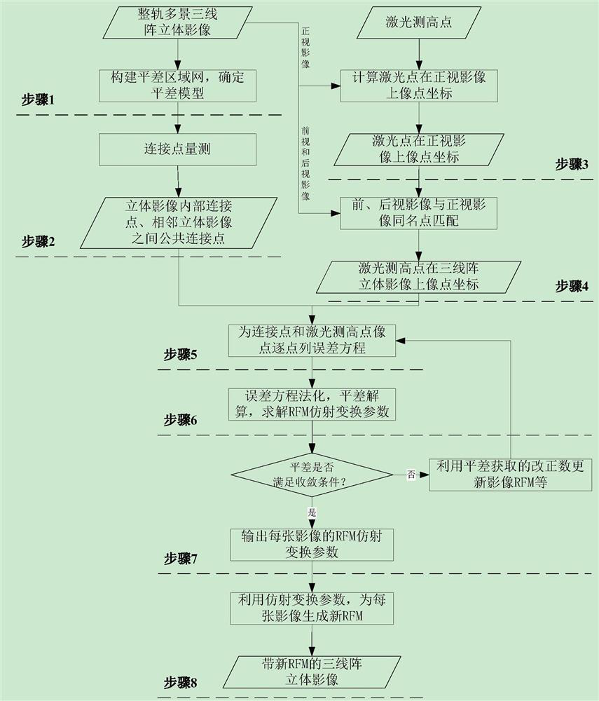
[0022] like figure 1 As shown in the figure, it is the process flow of the joint surveying and mapping processing method of the same-track laser height measuring point and the three-line array stereoscopic image, including the following steps:

[0023] Step 1, taking the satellite imaging photographic orbit as a unit, construct an adjustment block network with multi-view three-line array stereo images of the same orbit, and adopt the block network adjustment model based on the affine transformation compensation rational function model (RFM) of the image square;

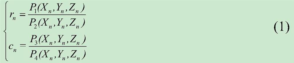
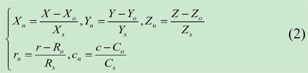
[0024] RFM refers to the use of rational polynomials to establish the mathematical mapping relationship between the pixel coordinates of the image and the geodetic coordinates of the co...


PUM


Abstract

The invention discloses a combined surveying and mapping processing method of laser altimetry points and three-line array stereoscopic images on the same track. In the method, the laser altimetry points are used as elevation control points, and the relative plane error of the orthographic images obtained by the laser altimetry points and the same track is used. Smaller features, to obtain the accurate image square coordinates of the laser altimetry points distributed in various terrain types (especially hills and mountainous terrain) on the three-line array stereo image; Construct the adjustment area network, and carry out the joint area network adjustment of the laser altimetry point and the stereo image; finally, update the imaging geometric model of the stereo image according to the adjustment results. The invention makes full use of the advantages of laser altimetry points and optical images being acquired on the same track and has extremely high elevation accuracy. Under the condition of no ground control point, the elevation accuracy of the three-line array stereoscopic image is effectively improved, and it provides a global high-precision solution for the use of satellite images. The construction of geographic information resources provides technical support.

Description

technical field [0001] The invention belongs to the technical field of remote sensing and photogrammetry, and relates to a combined geometric processing method of a laser height measuring point and a three-dimensional image, in particular to a combined surveying and mapping processing method of a laser height measuring point and a three-line array stereo image acquired on the same track. Background technique [0002] Mapping satellite stereo images have now become the main data source for multi-scale surveying and mapping geographic information products around the world. The biggest difficulty in using satellite stereo images to carry out surveying and mapping applications is to ensure the geometric accuracy of the images, especially the elevation accuracy. Although the geometric accuracy of satellite images can be effectively improved by using a sufficient amount of high-precision ground control data, when conducting global mapping applications, limited by political and eco...

Claims


Application Information

Patent Timeline
Patent Type & Authority Patents(China)
IPC IPC(8): G01C11/04G01C15/00
CPCG01C11/04G01C15/00
Inventor 周平唐新明王霞王懿哲岳明宇王艺颖张恒刘昌儒
Owner 自然资源部国土卫星遥感应用中心
Why Eureka
Try Eureka