Unmanned aerial vehicle remote sensing networking method and device based on three-level architecture and architecture

An unmanned aerial vehicle and aircraft remote sensing technology, which is applied in the field of unmanned aerial vehicles, can solve the problems of inability to meet the needs of real-time rapid, ultra-high-resolution remote sensing observation, scattered distribution, and restriction of the power performance of unmanned aerial vehicles.

Inactive Publication Date: 2019-07-19
INST OF GEOGRAPHICAL SCI & NATURAL RESOURCE RES CAS +1
View PDF7 Cites 3 Cited by
  • Summary
  • Abstract
  • Description
  • Claims
  • Application Information

AI Technical Summary

Problems solved by technology

[0004] Although the current unmanned aerial vehicle network cooperative observation technology is developing vigorously and the theoretical technology is becoming more and more perfect, it mainly focuses on task assignment in small areas and in the military field, which cannot meet the needs of real-time, fast, and ultra-high resolution remote sensing in a large area. Observation requirements are specifically reflected in the following aspects: (1) A single UAV is restricted by power performance, and it is difficult to achieve large-scale observation
Most of the current aircraft networking is to perform specific flight missions, and it is also limited to data acquisition in a small area
(2) There are many types of unmanned aerial platforms and sensors, most of which are independently designed, lack of unified specifications, poor standardization and versatility, and it is difficult to achieve data docking and sharing
(3) National drone remote sensing resources are lack of nearby deployment, scattered distribution, and difficult to dispatch, which limits the role of drone remote sensing in emergency situations such as earthquake relief and flood disaster monitoring.

Method used


Image

  • Unmanned aerial vehicle remote sensing networking method and device based on three-level architecture and architecture
  • Unmanned aerial vehicle remote sensing networking method and device based on three-level architecture and architecture
  • Unmanned aerial vehicle remote sensing networking method and device based on three-level architecture and architecture

Examples


Embodiment Construction

[0040] The present invention will be described in detail below with reference to the accompanying drawings and examples. It should be noted that, in the case of no conflict, the embodiments in the present application and the features in the embodiments can be combined with each other.

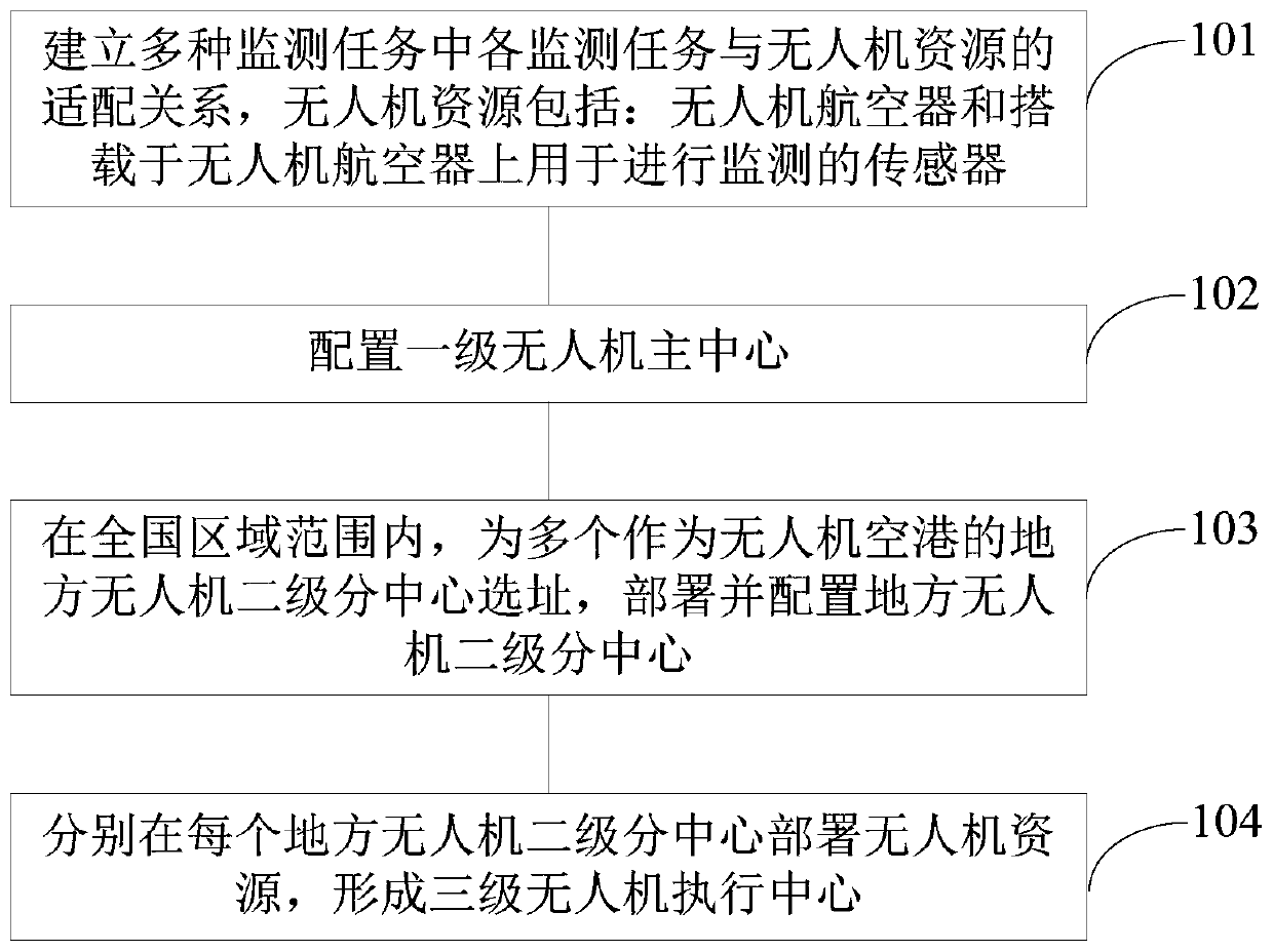
[0041] Aiming at the defects of the current UAV remote sensing networking, the present invention is oriented to monitoring tasks, especially the normalized ecological environment observation, flood disaster and homeland security emergency observation requirements, and proposes a national UAV remote sensing networking based on a three-level architecture method to realize high-frequency and rapid observation of UAVs and provide support for decision-making departments.

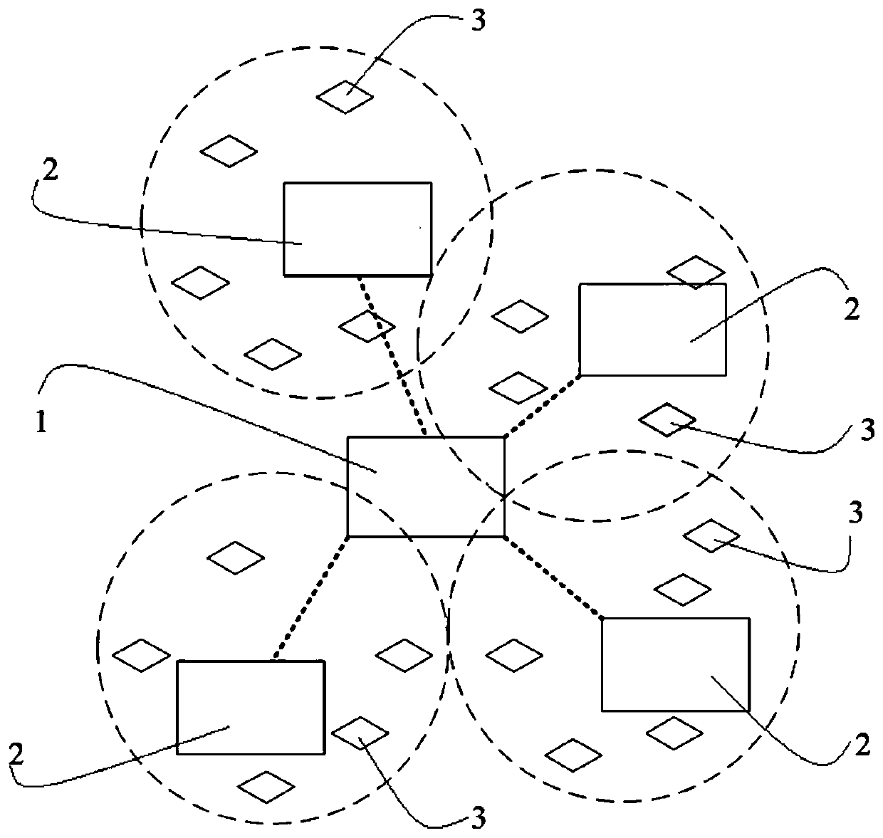
[0042] see figure 1 , an embodiment of the present invention provides a method for networking of unmanned aerial vehicles based on a three-level architecture, which includes the following steps:

[0043] Step S101 , establishing...


PUM


Abstract

The invention belongs to the technical field of unmanned aerial vehicles, and provides an unmanned aerial vehicle remote sensing networking method and device based on a three-level architecture and anarchitecture, and the method comprises the steps: establishing an adaptive relationship between each monitoring task in multiple monitoring tasks and an unmanned aerial vehicle resource; configuringa primary unmanned aerial vehicle main center; selecting a site for a plurality of local unmanned aerial vehicle secondary sub-centers serving as unmanned aerial vehicle air harbors within the nationwide area range, and deploying and configuring the local unmanned aerial vehicle secondary sub-centers; deploying unmanned aerial vehicle resources in each local unmanned aerial vehicle second-level sub-center to form a third-level unmanned aerial vehicle execution center. The networking device comprises an adaptive relation establishing module, a first-level unmanned aerial vehicle main center configuration module, a local unmanned aerial vehicle second-level sub-center deployment and configuration module and a third-level unmanned aerial vehicle execution center configuration module. The networking architecture comprises a first-level unmanned aerial vehicle main center, a local unmanned aerial vehicle second-level sub-center and a third-level unmanned aerial vehicle execution center. According to the method, high-frequency and rapid observation of the unmanned aerial vehicle can be realized when a monitoring task is oriented, and support is provided for a decision-making department.

Description

technical field [0001] The present invention relates to the technical field of unmanned aerial vehicles, in particular to a method, device and architecture for remote sensing networking of unmanned aerial vehicles based on a three-level architecture. Background technique [0002] In recent years, with the continuous development of earth observation technology, the rapid acquisition of spatial information with centimeter-level ultra-high resolution, hour-level or even near real-time response, and high-frequency revisiting has been continuously improved. Unmanned aerial remote sensing has the characteristics of flexible maneuverability, short data acquisition cycle, high safety factor, and all-day observation, and has been widely used in various industries. However, unmanned aerial remote sensing has constrained conditions such as low efficiency of aircraft stand-alone operation, lack of network coordination, poor adaptability of load platforms, and insufficient collaborative ...

Claims


Application Information

Patent Timeline
Patent Type & Authority Applications(China)
IPC IPC(8): H04B7/185G01D21/02
CPCG01D21/02H04B7/18506
Inventor 廖小罕鹿明岳焕印
Owner INST OF GEOGRAPHICAL SCI & NATURAL RESOURCE RES CAS
Why Eureka
Try Eureka