
Dynamic K nearest neighbor map matching method combined with deep network

A map matching and deep network technology, applied in the field of map matching, can solve problems such as inherent errors of user receivers, deviations between GPS positioning points and actual positions, and inability to measure propagation delay errors

Active Publication Date: 2019-08-02
CHANGAN UNIV
View PDF5 Cites 3 Cited by
  • Summary
  • Abstract
  • Description
  • Claims
  • Application Information

AI Technical Summary

Problems solved by technology

However, since the GPS system always has unavoidable errors in the process of data collection (such as the propagation delay error generated by the satellite and its propagation path itself, which cannot be measured or calculated by the correction model, and the inherent error of the user receiver), resulting in There is a deviation between the obtained GPS positioning point and the actual position

Method used


Image

  • Dynamic K nearest neighbor map matching method combined with deep network
  • Dynamic K nearest neighbor map matching method combined with deep network
  • Dynamic K nearest neighbor map matching method combined with deep network

Examples


Embodiment Construction

[0047] The present invention will be described in further detail below in conjunction with the accompanying drawings.

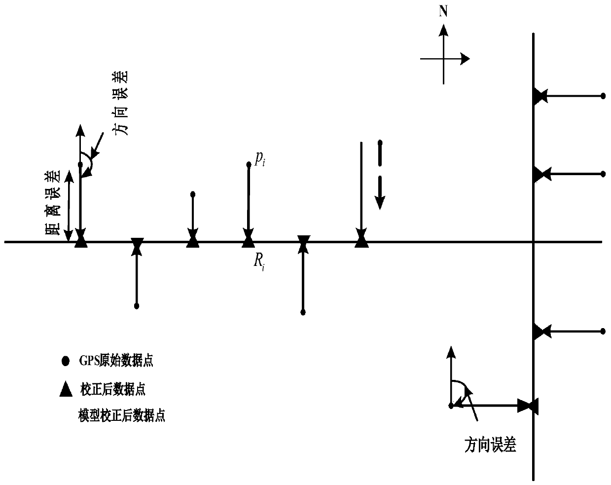
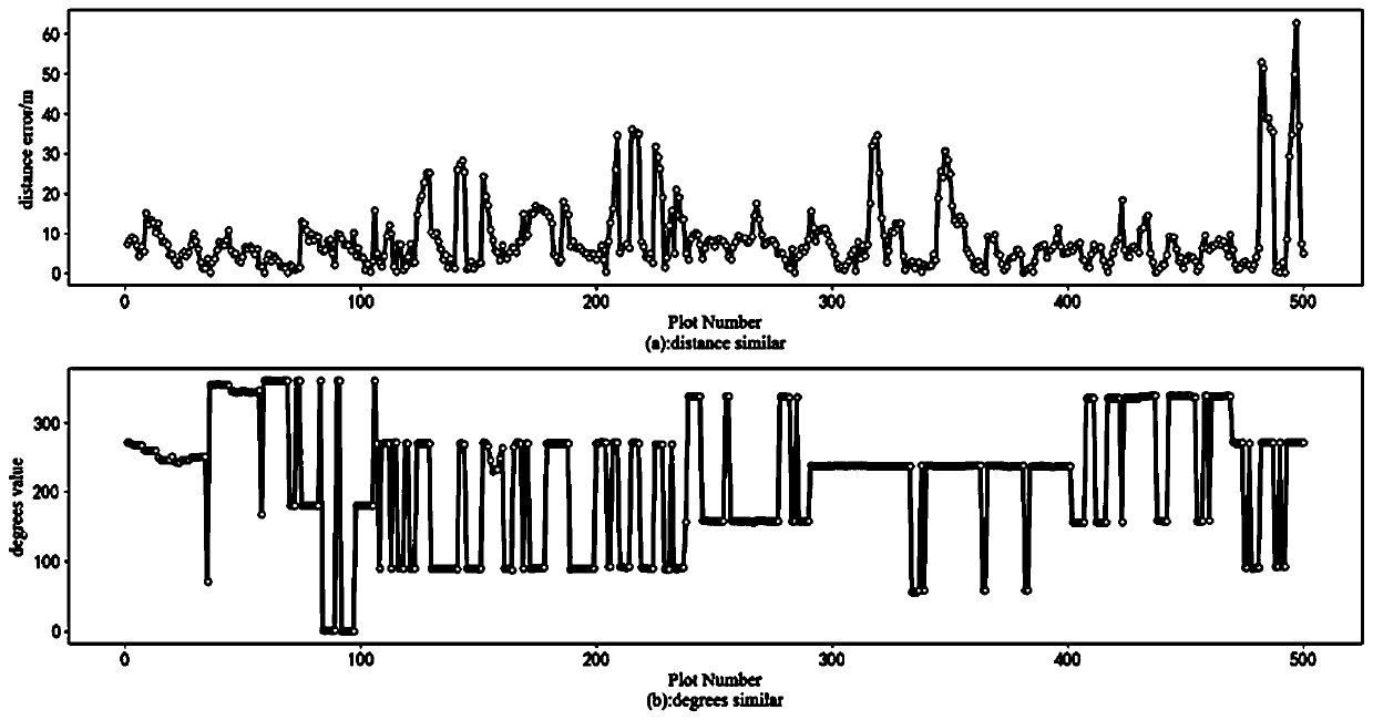
[0048] 1. Define the trajectory sequence as T, T is a series of continuous GPS positioning points p 1 ,p 2 ,...,p n , each anchor point contains longitude (p i .lat), latitude (p i .lon), time (p i .time), speed (p i .velocity), heading angle (p i .path-angle) and other features. 2. Define distance error: Assume R i is the anchor point p i , then the R i with p i distance error Such as figure 1 shown. 3. Define the direction error: Assume R i is the anchor point p i , then the R i ,p i The clockwise angle between the connecting line and the true north direction is called the direction error Such as figure 1shown. 4. Define the error similarity of the adjacent area: GPS positioning point p i with adjacent point p i-n ,...,p i-1 and p i+1 ,...,p m+1 (where m, n∈N * )of and There are similarities between. see figure 2 ,From f...


PUM


Abstract

A dynamic K nearest neighbor map matching method combined with a deep network is disclosed. The method comprises the following steps of step1, collecting GPS data, and carrying out data cleaning on anoise generated during a GPS data acquisition process; step2, through map matching, acquiring a distance error and a direction error in experimental data; step3, normalizing input data of a multi-layer perceptron, taking a normalized latitude and longitude as input of a multi-layer perceptron model, and training the multi-layer perceptron model to obtain a dynamic k value; step4, combining each test data with an Euclidean distance according to the trained k value, and using a k-nearest neighbor algorithm to obtain a predicted distance error and a predicted direction error of the test data, andthen acquiring a projection point of a corresponding test point; and step5, acquiring the projection point of the test data according to the longitude and the latitude of the test data, the predicteddistance error and the predicted direction error. In the invention, a global single k value condition existing in the k nearest neighbor algorithm can be improved and an optimal error value can be acquired.

Description

technical field [0001] The invention belongs to the technical field of map matching, and relates to a dynamic K-nearest neighbor map matching method combined with a deep network. Background technique [0002] With the development and popularization of global positioning technology, more and more devices are embedded with GPS (global position system) global positioning function. These devices can collect a large amount of mobile location data every day, which contains a wealth of traffic information and user behavior, which can be applied to research such as route prediction, GPS trajectory analysis, and activity recognition. However, since the GPS system always has unavoidable errors in the data collection process (such as propagation delay errors generated by the satellite and its propagation path itself, which cannot be measured or calculated with a correction model, and inherent errors of the user receiver), resulting in There is a deviation between the obtained GPS posi...

Claims


Application Information

Patent Timeline
IPC IPC(8): G01C21/30
CPCG01C21/30
Inventor 陈柘刘婷赵斌段宗涛樊娜康军唐蕾
Owner CHANGAN UNIV
Learn More