Salinized soil salt content estimation method based on surface image

A technology of salt content and saline soil, which is applied in the field of salt content estimation of saline soil based on surface images, can solve the problems of complex measurement results and inaccuracy of salt content measurement methods, and achieve fast calculation speed and complex identification Low cost, saving manpower and material resources

Active Publication Date: 2019-08-09
NORTHEAST INST OF GEOGRAPHY & AGRIECOLOGY C A S
View PDF9 Cites 2 Cited by
  • Summary
  • Abstract
  • Description
  • Claims
  • Application Information

AI Technical Summary

Problems solved by technology

[0006] The purpose of the present invention is to solve the problem of complex and inaccurate measurement results of the existing salt content measurement method, and provide a saline soil salt content estimation based on surface images method

Method used


Image

  • Salinized soil salt content estimation method based on surface image
  • Salinized soil salt content estimation method based on surface image
  • Salinized soil salt content estimation method based on surface image

Examples


specific Embodiment approach 1

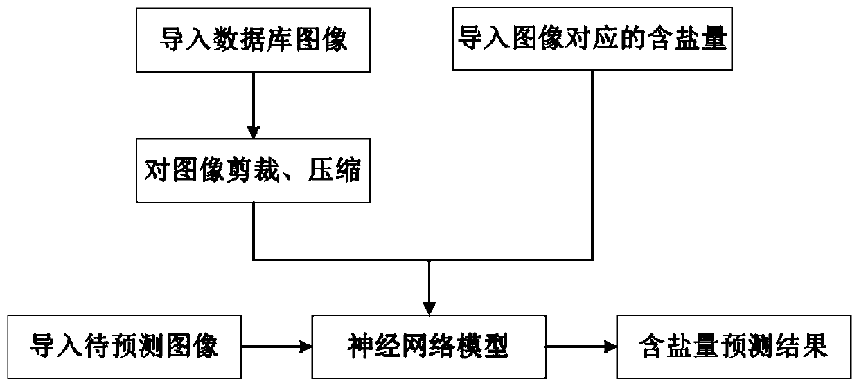
[0020] Specific implementation mode one: the method for estimating the salt content of saline soil based on surface images in this implementation mode includes the following steps:

[0021] Step 1. Shoot surface images, collect soil samples, and test the salinity data of the soil samples taken from the surface images: cut the surface images into uniform pixel images, and correspond to the salt content data one by one, and establish the surface image and salt content data. Quantitative database to obtain the training data database;

[0022] Step 2. According to the training data database, the feature extraction algorithm of the surface image is established based on CNN, and the model is established;

[0023] Step 3. Let the loss function be the sum of the absolute values ​​of all image training errors;

[0024] Step 4, substituting the characteristics of the surface image obtained in step 2 and the salt content determined in step 1 into the model of step 2 for training, and ca...

specific Embodiment approach 2

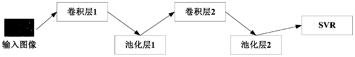
[0029] Embodiment 2: The difference between this embodiment and Embodiment 1 is that in step 2, the CNN includes an input layer, a convolution layer, a pooling layer, a RELU layer, a fully connected layer and an output layer. Others are the same as the first embodiment.

specific Embodiment approach 3

[0030] Embodiment 3: The difference between this embodiment and Embodiment 1 or 2 is that the calculation method of the training error in Step 4 is: Substituting the characteristics of the surface image into the model to obtain an estimated value, and then the estimated value corresponds to the surface image Subtract the salinity to get the training error. Others are the same as those in Embodiment 1 or 2.


PUM


Abstract

The invention discloses a salinized soil salt content estimation method based on a surface image in order to solve the problems that an existing salt content measuring method is complex and a measuring result is inaccurate. The method comprises the steps that two-dimensional information such as color, texture and brightness of a surface image is fully extracted on the basis of a convolutional neural network algorithm, and finally a relation model of image characteristics and the salt content is established through a support vector machine regression method. The algorithm is low in recognitioncomplexity, high in speed and good in stability, and a simple, accurate and efficient salinized soil salt estimation method is achieved. The method is applied to the fields of remote sensing, agriculture and the like.

Description

technical field [0001] The invention relates to a method for estimating the salt content of saline soil based on surface images. Background technique [0002] Saline soil is a collective term for a series of soils affected by salt and alkali formed under the combined action of various natural environmental factors and human activity factors. Due to the large amount of soluble salts in the soil, the normal growth of crops in the soil is inhibited. According to the salinization degree, saline soil can be divided into mild saline-alkali soil (soil salt content 0.1-0.2%), moderate saline-alkali soil (soil salt content 0.2-0.4%) and severe saline-alkali soil (soil salt content 0.4 ~0.6%). From the perspective of the surface state, vegetation can grow on the surface of mild and moderate saline-alkali soil, while the surface of severe saline-alkali soil is bare soil without vegetation growth. [0003] Due to climate drought and unreasonable human activities, soil salinization an...

Claims


Application Information

Patent Timeline
Patent Type & Authority Applications(China)
IPC IPC(8): G06K9/62G06T7/40G06T7/90G06N3/04
CPCG06T7/40G06T7/90G06N3/045G06F18/2411G06F18/214
Inventor 李晓洁
Owner NORTHEAST INST OF GEOGRAPHY & AGRIECOLOGY C A S
Why Eureka
Try Eureka