Supercharge Your Innovation With Domain-Expert AI Agents!

Evaluation method for topogeology and geology conditions of planned arch dam site

A technology of geological conditions and evaluation methods, applied in the field of arch dam engineering, can solve problems such as large individual differences, affecting arch dams, and weak guidance for arch dam layout design, achieving good guidance and simple results

Active Publication Date: 2019-08-16
POWERCHINA CHENGDU ENG
View PDF6 Cites 5 Cited by
  • Summary
  • Abstract
  • Description
  • Claims
  • Application Information

AI Technical Summary

Problems solved by technology

[0003] At present, the complexity of topographic and geological conditions of dam sites is often judged based on the experience of designers, and there is no quantitative evaluation standard, resulting in large individual differences. The guidance for the layout design of arch dams is not strong, affecting the basis Targeted design based on topographic and geological conditions of the dam site

Method used


Image

  • Evaluation method for topogeology and geology conditions of planned arch dam site
  • Evaluation method for topogeology and geology conditions of planned arch dam site
  • Evaluation method for topogeology and geology conditions of planned arch dam site

Examples


Embodiment Construction

[0027] The present invention will be further described below in conjunction with accompanying drawing.

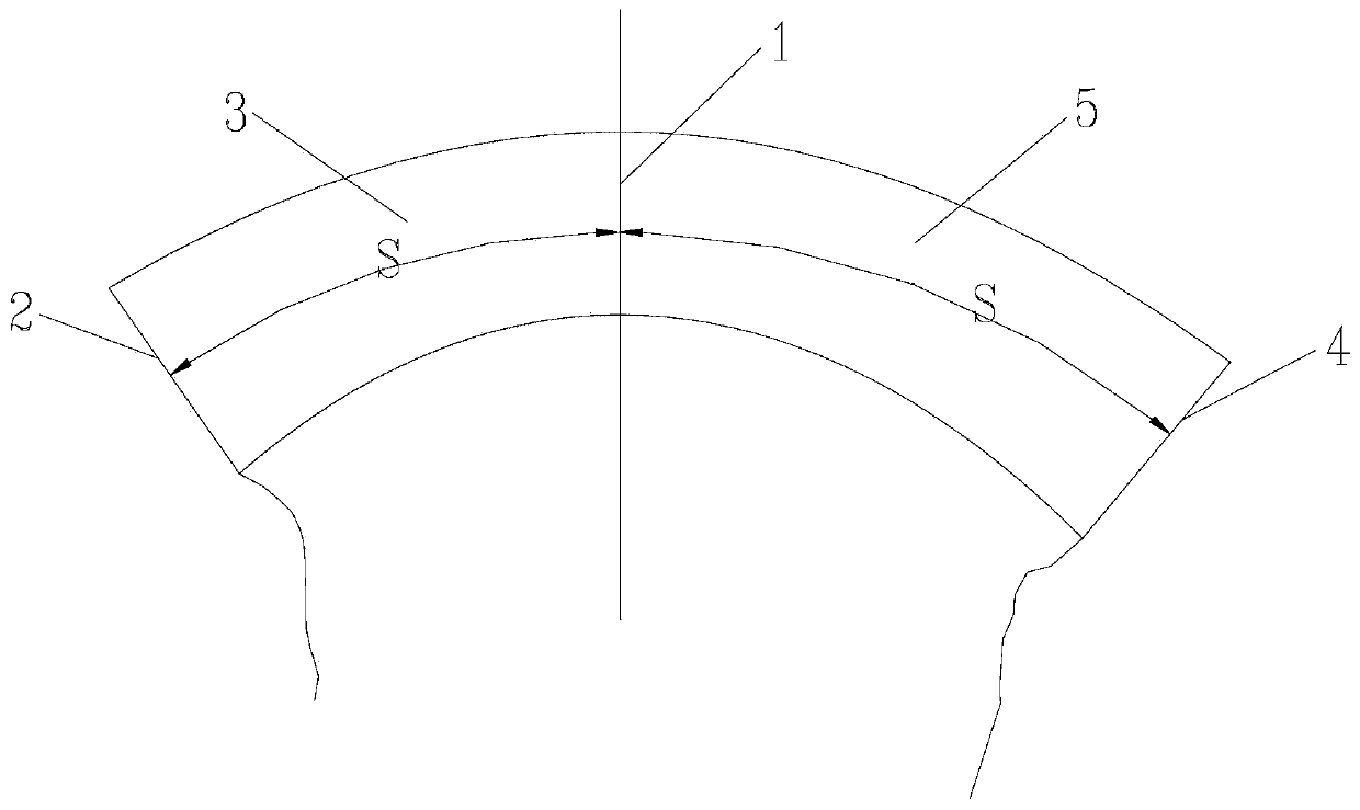
[0028] Such as figure 1 As shown, a method for evaluating the topographic and geological conditions of a proposed arch dam site includes the following steps:

[0029] a. Along the dam height direction of the proposed arch dam, divide the arch ring of the proposed arch dam into several sequentially connected sub-arch rings from bottom to top; the arch ring, as the main structure of the arch dam, acts as a water retaining The borne water load is transmitted to the dam foundation 2 on the left bank and the dam foundation 4 on the right bank, depending on the height of the arch dam, preferably the height of each sub-arch ring is 40m.

[0030] b. Taking the arch dam centerline 1 as the boundary line, the arch dam centerline 1 refers to the connection line between the crown point of the arch circle and the focal point of the curve of the center section of the arch circle. The d...


PUM


Abstract

The invention relates to an evaluation method for topogeology and geology conditions of a planned arch dam site, which belongs to the technical field of arch dam engineering and comprises the following steps of: a, dividing an arch ring of the planned arch dam into a plurality of branch arch rings which are sequentially connected from bottom to top along the dam height direction of the planned arch dam; b, dividing the branch arch rings into left branch arch rings and right branch arch rings; c, selecting the arc lengths S of the arch rings corresponding to the left branch arch rings and the right branch arch rings and the dam foundation deformation modulus E as evaluation parameters; d, calculating the evaluation parameters S and E of the corresponding elevation according to a formula f =S / E; e, obtaining single macrotopography geological complexity evaluation parameters Epsilon according to the eta fl and the eta fr obtained in the step d; f, making a terrain and geology complexityindex M; and g, carrying out terrain and geological condition evaluation of the arch dam site. According to the evaluation method, the complexity of quantitative evaluation of the arch dam site terrain geological conditions is achieved, and good guidance is provided for arch dam arrangement and design.

Description

technical field [0001] The invention relates to a method for evaluating topographic and geological conditions of a planned arch dam site, and belongs to the technical field of arch dam engineering. Background technique [0002] Arch dam is a dam type with better safety and economy, but arch dam has relatively high requirements on terrain and geological conditions. Under symmetrical terrain and geological conditions, the stress and displacement of the arch dam are relatively uniform and symmetrical, which is an ideal situation, but most of the dam site conditions cannot meet the ideal dam site condition requirements. For long-term safe operation, there is a moderate safety reserve. When the arch dam is arranged, it should be designed according to the complexity of the topographic and geological conditions of the dam site. [0003] At present, the complexity of topographic and geological conditions of dam sites is often judged based on the experience of designers, and there i...

Claims


Application Information

Patent Timeline
IPC IPC(8): G06F17/50
CPCG06F30/13
Inventor 张敬刘小强赵艳李金洋
Owner POWERCHINA CHENGDU ENG
Features
  • R&D
  • Intellectual Property
  • Life Sciences
  • Materials
  • Tech Scout
  • Unparalleled Data Quality
  • Higher Quality Content
  • 60% Fewer Hallucinations
Learn More