Generating method and system of autopilot navigation map, vehicle terminal and server

A technology for navigation maps and automatic driving, applied in directions such as road network navigators, can solve the problems of low map update efficiency and slow update speed, and achieve the effects of improving accuracy, reducing errors, and improving stability and reliability.

Active Publication Date: 2019-08-20
BEIJING CHUSUDU TECH CO LTD
View PDF8 Cites 16 Cited by
  • Summary
  • Abstract
  • Description
  • Claims
  • Application Information

AI Technical Summary

Problems solved by technology

However, in practice, it is found that this electronic map update scheme needs to identify the changed target object through manual labeling, resulting in low map update efficiency and slow update speed.

Method used


Image

  • Generating method and system of autopilot navigation map, vehicle terminal and server
  • Generating method and system of autopilot navigation map, vehicle terminal and server
  • Generating method and system of autopilot navigation map, vehicle terminal and server

Examples


Embodiment 1

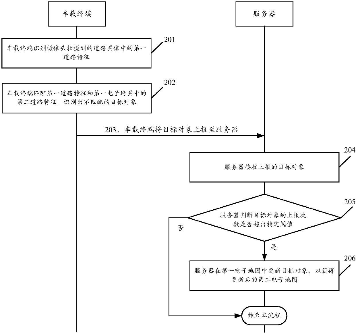
[0070] See figure 2 , figure 2 It is a schematic flowchart of a method for generating an automatic driving navigation map disclosed in an embodiment of the present invention. Wherein, the method is applied to in-vehicle terminals such as an in-vehicle computer and an in-vehicle industrial control computer (Industrial Personal Computer, IPC), which is not limited in the embodiment of the present invention. Such as figure 2 As shown, the method for generating the autonomous driving navigation map may include the following steps:

[0071] 201. The vehicle-mounted terminal recognizes a first road feature in a road image captured by a camera.

[0072] In the embodiment of the present invention, the viewfinder range of the camera includes at least the environment in front of the vehicle, the camera and the vehicle-mounted terminal may have data transmission, and the vehicle-mounted terminal obtains real-time road images captured by the camera during the driving of the vehicle. As an ...

Embodiment 2

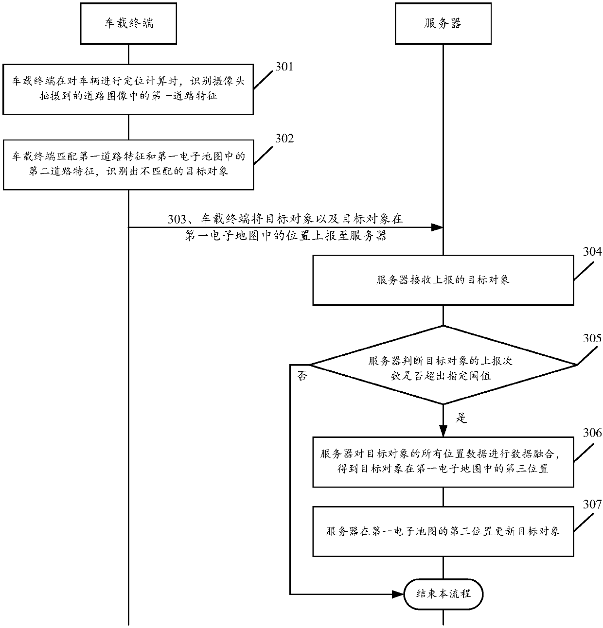
[0091] See image 3 , image 3 It is a schematic flowchart of another method for generating an automatic driving navigation map disclosed in an embodiment of the present invention. Such as image 3 As shown, the method for generating the autonomous driving navigation map may include the following steps:

[0092] 301. The vehicle-mounted terminal recognizes the first road feature in the road image captured by the camera when performing positioning calculation of the vehicle.

[0093] In the embodiment of the present invention, the viewfinder range of the camera includes at least the environment in front of the vehicle. Those skilled in the art can understand that a possible implementation manner for the vehicle-mounted terminal to perform positioning calculation for the vehicle may be as follows: identify the first road feature in the road image, and according to the automatic navigation electronic map matching the first road feature Feature position, calculate the position of the ...

Embodiment 3

[0126] See Image 6 , Image 6 It is a schematic structural diagram of a vehicle-mounted terminal disclosed in an embodiment of the present invention. Such as Image 6 As shown, the vehicle-mounted terminal may include:

[0127] The recognition unit 601 is used for recognizing the first road feature in the road image captured by the camera; wherein the viewfinder range of the camera includes at least the front environment of the vehicle where the vehicle-mounted terminal is located.

[0128] In the embodiment of the present invention, as an optional implementation manner, the recognition unit 601 may recognize the first road feature in the road image through a pre-trained semantic feature detection model. The semantic feature detection model may be a deep learning neural network. The aforementioned semantic feature detection model uses a large number of sample images marked with the aforementioned first road feature as training input, and finally a deep learning neural network obta...


PUM


Abstract

A generating method and a system of an autopilot navigation map, a vehicle terminal and a server. The method comprises steps of identifying features of a first road in a road image captured by a camera, wherein the capturing range of the camera includes at least a view in front of a vehicle; matching the features of the first road with features of a second road in a first electronic map, identifying a non-matched target object that is any one of the features of the first road unmatched with the features of the second road or any one of the features of the second road unmatched with the features of the first road; reporting the target object to the server, and updating the target object in the first electronic map by the server when the report frequency of the target object exceeds a specified threshold, and then obtaining the updated second electronic map. By implementing the embodiment of the present invention, the autopilot navigation map can be automatically updated without manual labeling, thereby improving updating efficiency and updating speed of the map.

Description

Technical field [0001] The present invention relates to the field of automatic driving technology, in particular to a method, system, vehicle-mounted terminal and server for generating an automatic driving navigation map. Background technique [0002] The autonomous driving navigation map is an important part of the autonomous driving technical solution and the basis for the realization of autonomous driving navigation. In real life, the road conditions may change at any time, such as the damage, increase and replacement of road signs, and the closure of road forks due to temporary construction. In order to ensure driving safety, the electronic map needs to be updated in time to adapt to changes in actual road conditions and reduce the probability of accidents. [0003] The existing electronic map update program relies on map manufacturers to use special map data to collect vehicles to drive on the road sections that may be changed, and manually mark the target objects (such as si...

Claims


Application Information

Patent Timeline
Patent Type & Authority Applications(China)
IPC IPC(8): G01C21/32
CPCG01C21/32
Inventor 杜志颖单乐
Owner BEIJING CHUSUDU TECH CO LTD
Why Eureka
Try Eureka