A Method Model for Obtaining Evi Index of High Spatiotemporal Time Series Based on Bayesian Theory

A Bayesian theory, space-time technology, applied in the field of vegetation remote sensing, can solve problems such as data optimization weakening, EVI error, limited processing capacity, etc., and achieve the effect of improving accuracy

Active Publication Date: 2021-03-05
BEIJING NORMAL UNIVERSITY
View PDF4 Cites 0 Cited by
  • Summary
  • Abstract
  • Description
  • Claims
  • Application Information

AI Technical Summary

Problems solved by technology

Although this method is simple and easy to implement, it only uses high-resolution data to calculate the area components, and the spatial detail information of high-resolution images is not used. The values ​​of the sub-pixels are the same. However, due to the differences in water and soil environment and biological characteristics, even at a small scale, the vegetation index of the pixels of the same vegetation category will generally be different. Therefore, the image obtained by the decomposition of mixed pixels is not A real high-spatial-resolution image, and the decomposed image will have patches at the scale of the decomposition window, which will greatly affect the appearance
There is also a high chance of getting unrealistic decomposition values
[0005] Many existing models that fuse high spatial and temporal resolution data have many errors that can be optimized and weakened due to their incomplete principles and incomplete theories.
And in the research of vegetation remote sensing, the vegetation index NDVI is commonly used to reflect the dynamic changes of vegetation growth, but in the period of vigorous vegetation (vegetation coverage exceeds 80%), NDVI will appear saturated, and NDVI is easily affected by noise, especially in In water body areas and near urban construction areas, the ability to deal with atmospheric background and soil background is limited, and EVI has been improved in these aspects, but there are still errors in the EVI obtained by the existing method model

Method used


Image

  • A Method Model for Obtaining Evi Index of High Spatiotemporal Time Series Based on Bayesian Theory
  • A Method Model for Obtaining Evi Index of High Spatiotemporal Time Series Based on Bayesian Theory
  • A Method Model for Obtaining Evi Index of High Spatiotemporal Time Series Based on Bayesian Theory

Examples


Embodiment Construction

[0031] In order to make the object, technical solution and advantages of the present invention more clear, the present invention will be further described in detail below in conjunction with the examples. It should be understood that the specific embodiments described here are only used to explain the present invention, not to limit the present invention.

[0032] The application principle of the present invention will be further described below in conjunction with accompanying drawings and specific embodiments:

[0033] The reference signs in the drawings of the description include:

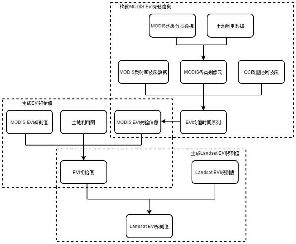
[0034] The embodiment is based on the attached figure 1 Shown:

[0035] The method model for obtaining the EVI index of high space-time time series based on Bayesian theory includes the following generation steps:

[0036] (1) Construct MODIS EVI prior information:

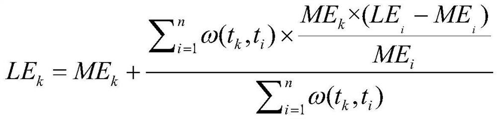
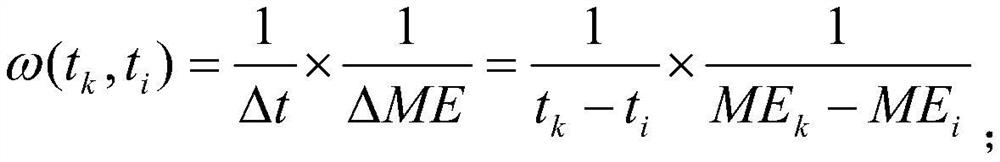
[0037] S110. Superimpose the MODIS land surface classification data and land use data in space, judge the superimposed data, a...


PUM


Abstract

The invention belongs to the technical field of vegetation remote sensing, and discloses a method model based on Bayesian theory to obtain high time-series EVI index, comprising the following generation steps: (1) constructing MODIS EVI prior information: combining MODIS surface classification data and land use data in Superimpose in space, judge and extract MODIS pixels of each category; combine MODIS reflectance band data and its QC quality control band to obtain EVI mean time series; carry out filter reconstruction; (2) generate EVI initial value: use Bay The Yasian theory introduces the MODIS EVI prior information; combined with the land use map, the MODIS EVI prior information and the MODIS EVI observation value are decomposed into mixed pixels; (3) Generate Landsat EVI prediction value and use EVI data to predict The model uses the Landsat EVI observations at paired moments to reconstruct the initial value of EVI. Based on Bayesian theory, the present invention fuses Landsat high spatial resolution data and MODIS high temporal resolution data, and finally obtains EVI data with high temporal and spatial resolution.

Description

technical field [0001] The invention belongs to the technical field of vegetation remote sensing, and in particular relates to a method model for obtaining high time-space time-series EVI index based on Bayesian theory. Background technique [0002] MODIS vegetation vegetation products currently generate two global terrestrial vegetation index products, one is the normalized difference vegetation index NDVI, and the other is the enhanced vegetation index EVI, which is used in vegetation remote sensing research. At present, there are many method models to obtain EVI index with high spatial resolution and high temporal resolution, which can be mainly divided into the following categories: data fusion, mixed pixel decomposition, data assimilation and several methods combination model. [0003] STARFM (Spatial and Temporal Adaptive Reflectance Fusion Model) is a typical data fusion method, which obtains the regression relationship between Landsat values ​​and MODIS values ​​thr...

Claims


Application Information

Patent Timeline
Patent Type & Authority Patents(China)
IPC IPC(8): G06K9/62
CPCG06F18/25G06F18/29
Inventor 宋金玲罗倩程文乾杨磊朱筱
Owner BEIJING NORMAL UNIVERSITY
Why Eureka
Try Eureka