Road marker identification method and device and storage medium

A road sign and technology to be recognized, applied in the field of information processing, can solve the problems affecting the recognition efficiency, the overall size, and the direction cannot be determined

Active Publication Date: 2019-08-23
TENCENT TECH (SHENZHEN) CO LTD
View PDF12 Cites 19 Cited by
  • Summary
  • Abstract
  • Description
  • Claims
  • Application Information

AI Technical Summary

Problems solved by technology

This method based on ray intersection can save the step of preprocessing point cloud data, but the method of ray intersection can only locate the center point of the road marker more accurately, and the overall size and orientation cannot be determined
In order to obtain accurate results, it still needs to rely on a lot of manual work to correct the results, which affects the overall recognition efficiency

Method used


Image

  • Road marker identification method and device and storage medium
  • Road marker identification method and device and storage medium
  • Road marker identification method and device and storage medium

Examples


Embodiment Construction

[0036] The following will clearly and completely describe the technical solutions in the embodiments of the present invention with reference to the accompanying drawings in the embodiments of the present invention. Obviously, the described embodiments are only some, not all, embodiments of the present invention. Based on the embodiments of the present invention, all other embodiments obtained by persons of ordinary skill in the art without creative efforts fall within the protection scope of the present invention.

[0037] The terms "first", "second", "third", "fourth", etc. (if any) in the description and claims of the present invention and the above drawings are used to distinguish similar objects and not necessarily Describe a particular order or sequence. It is to be understood that the data so used are interchangeable under appropriate circumstances such that the embodiments of the invention described herein are, for example, capable of practice in sequences other than th...


PUM


Abstract

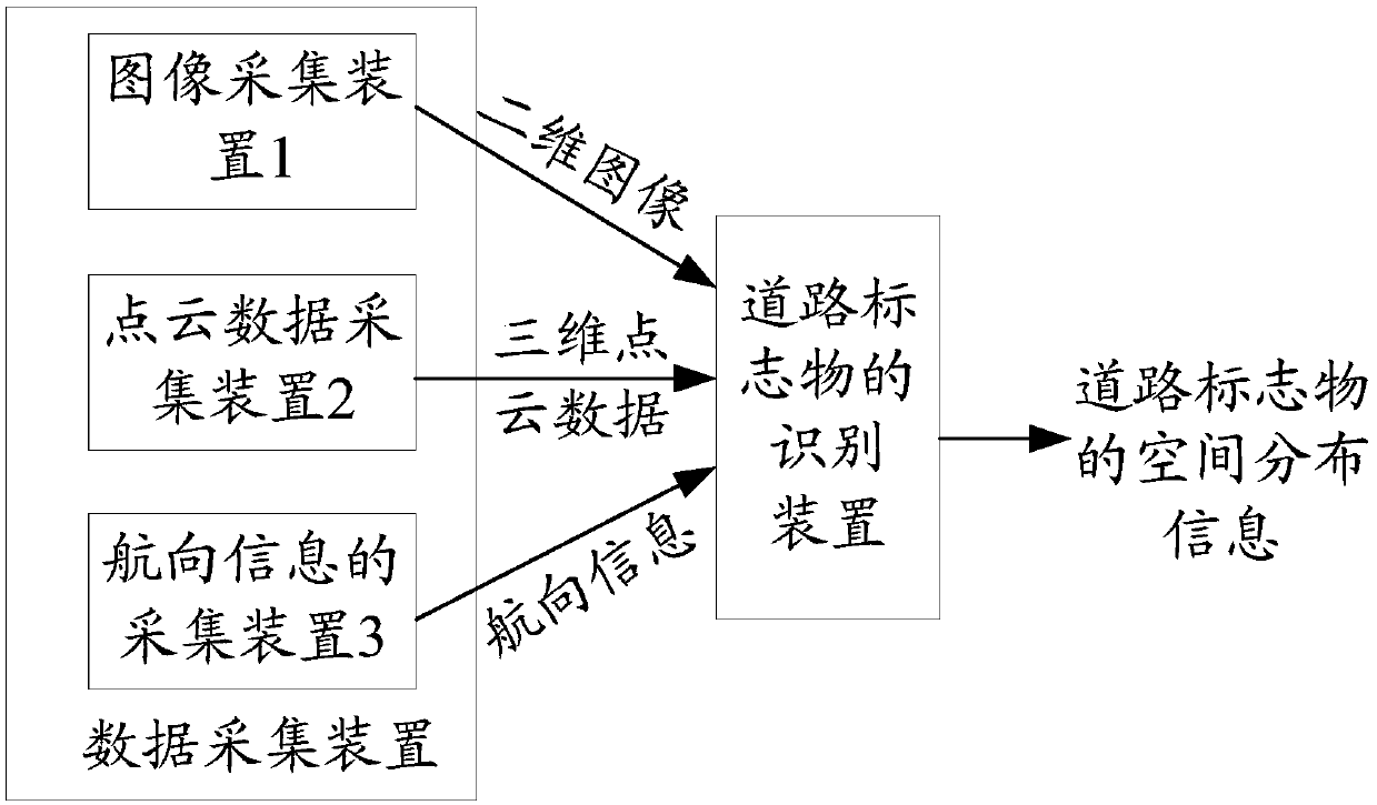
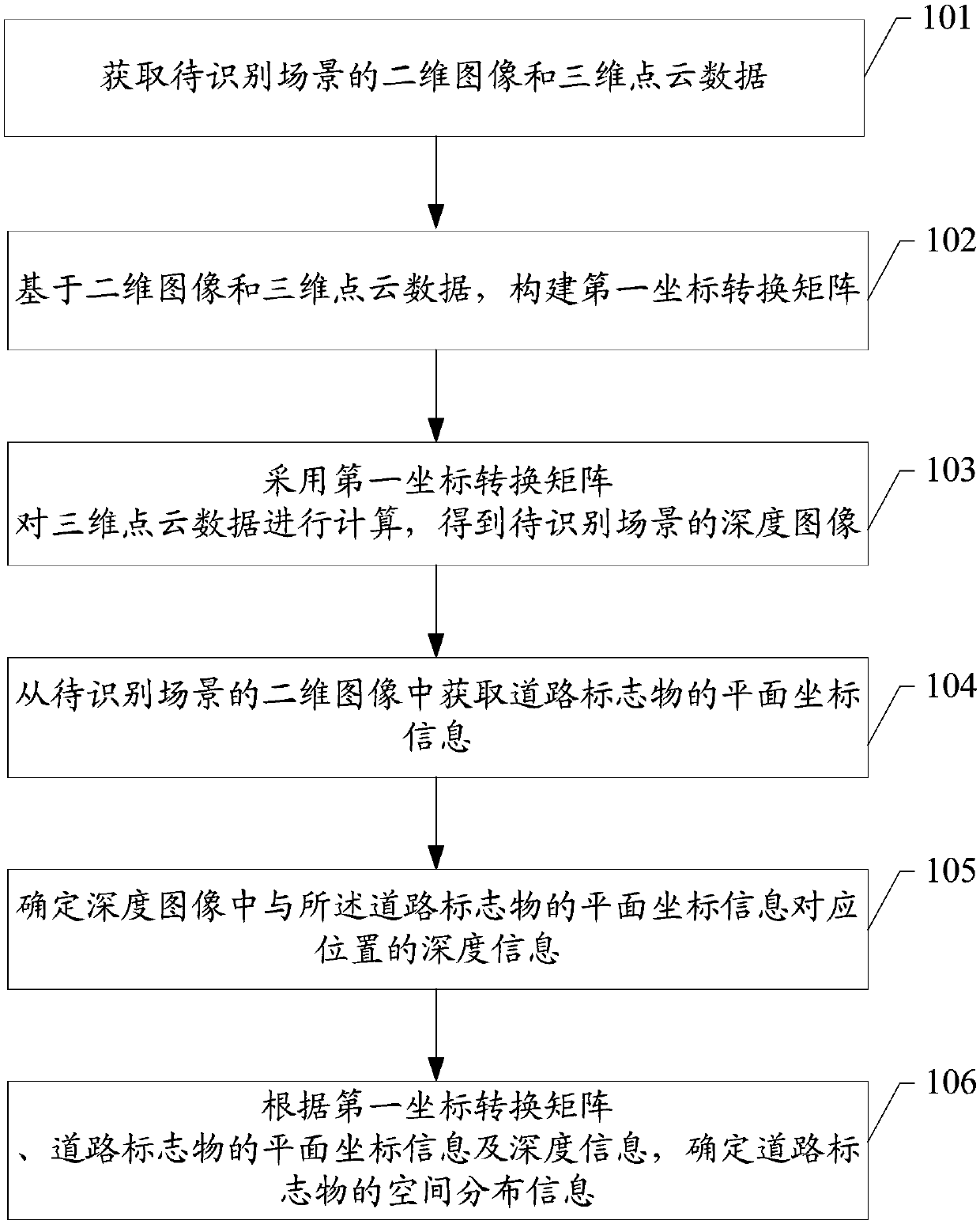
The embodiment of the invention discloses a road marker identification method and device and a storage medium, and is applied to the technical field of information processing. The road marker identification device firstly constructs a first coordinate transformation matrix based on a two-dimensional image and three-dimensional point cloud data of a scene to be recognized, and calculates the three-dimensional point cloud data by adopting the first coordinate transformation matrix to obtain a depth image of the scene to be recognized; therefore, as long as the plane coordinate information of theroad marker is acquired from the two-dimensional image of the scene to be identified, the depth information of the corresponding position in the depth image can be determined according to the plane coordinate information of the road marker; and then spatial distribution information of the road marker is determined according to the first coordinate transformation matrix and the plane coordinate information and depth information of the road marker, thereby realizing identification of the road marker. The automatic mapping process can be realized only by means of the depth image information of the to-be-identified scene, and the road marker can be efficiently positioned.

Description

technical field [0001] The present invention relates to the technical field of information processing, in particular to a method, device and storage medium for identifying road markers. Background technique [0002] Road signs, street signs and other road markers are important road elements in high-precision maps, which provide a reference for precise vehicle positioning and road condition recognition, so that autonomous vehicles can make accurate judgments about the surrounding environment and formulate appropriate driving strategies. Strategy. [0003] With the continuous improvement of traditional extraction algorithms and the continuous development of laser point cloud deep learning algorithms, the recognition and classification of road signs such as road signs and road signs on point clouds and images can have a high accuracy and recall rate, which can be very good. Improve the automation level of high-precision map production. Generally, in high-precision map data, r...

Claims


Application Information

Patent Timeline
Patent Type & Authority Applications(China)
IPC IPC(8): G06K9/00G06T7/73G06T7/80
CPCG06T7/73G06T7/80G06T2207/10028G06T2207/30256G06T2207/10004G06V20/582G06V2201/09
Inventor 江旻
Owner TENCENT TECH (SHENZHEN) CO LTD
Why Eureka
Try Eureka