Loess landform ditch line extraction method based on mean neighborhood

An extraction method and geomorphological technology, applied in image data processing, special data processing applications, instruments, etc., can solve problems such as low extraction efficiency, high requirements for operator knowledge and proficiency, and great impact on accuracy, so as to reduce Calculation amount, accurate analysis, effective automatic identification and extraction effect

Pending Publication Date: 2019-08-30
南京泛在地理信息产业研究院有限公司 +1
View PDF1 Cites 6 Cited by
  • Summary
  • Abstract
  • Description
  • Claims
  • Application Information

AI Technical Summary

Problems solved by technology

The line along the ditch can be obtained with a certain accuracy by using the field measurement method, but in general, the accuracy is greatly affected by the operator's subjectivity, and the extraction efficiency is low
The use of remote sensing images to delineate can obtain high-precision ditch lines, but when it comes to more complicated technical links such as later transfer drawing, it requires a higher level of knowledge and proficiency of the operator

Method used


Image

  • Loess landform ditch line extraction method based on mean neighborhood
  • Loess landform ditch line extraction method based on mean neighborhood
  • Loess landform ditch line extraction method based on mean neighborhood

Examples


Embodiment Construction

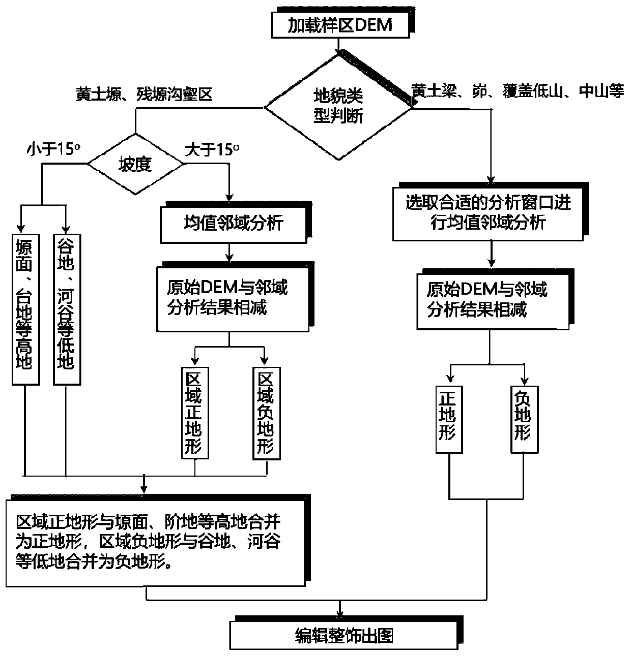
[0031] See figure 1 , which shows a flow chart of a method for extracting along loess landform ditch based on mean neighborhood according to the present invention.

[0032] The technical solutions of the present invention will be described in detail below, but the protection scope of the present invention is not limited to the embodiments.

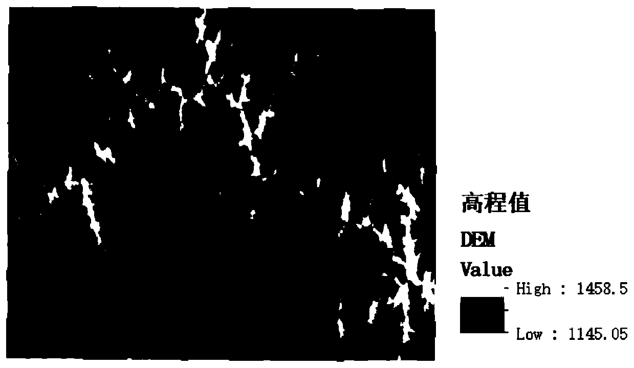
[0033] For such as figure 2 The DEM data of the Loess Liangmao-shaped hills and gullies sample area with a resolution of 5m shown, the following steps are adopted:

[0034] Step 1: Calculate the hillshade from the DEM data of the sample area, and superimpose it with the original DEM to make its three-dimensional shape more intuitive. The sample area is located in the loess beam-shaped hilly-gully area, 41 is selected as the number of analysis windows, and the mean neighborhood analysis is performed on the DEM data of the sample area using the focal statistics tool in ArcGIS. Whenever the analysis window slides on the grid DEM, the aver...


PUM


Abstract

The invention discloses a loess geomorphic ditch line extraction method based on a mean neighborhood, which comprises the following steps of firstly, taking the high-resolution grid DEM data of a research region as the basic data, and selecting a proper analysis window to carry out the mean neighborhood analysis according to the geomorphic type of the research region; subtracting the original DEMdata of the research area from a neighborhood analysis result, and extracting the planar data of a normal terrain area; and finally, editing and modifying the orthotopographic map spots, converting the orthotopographic map spots into the line data, and screening out the ditch lines according to the geographic meaning of the ditch lines to obtain a final ditch line extraction result. According to the method for extracting the loess landform ditch line based on the DEM data and the mean neighborhood, the more accurate and effective extraction of the loess landform ditch lines can be achieved, meanwhile, an existing ditch line extraction method system is supplemented, and the method has the guidance and practical significance for the loess plateau research in actual work.

Description

technical field [0001] The invention relates to a method for extracting along a loess plateau ditch, in particular to a method for extracting along a loess landform ditch based on a mean neighborhood. Background technique [0002] The study of the loess landform and its spatial differentiation is one of the key points in the study of the Loess Plateau. The ditch line, also known as the ditch margin line, valley margin line, ditch edge line, and mound edge line, is a special topographic structure line. The correct extraction and effective analysis of it is to explore the topography, soil erosion mode and land use of the Loess Plateau. The basis of the pattern. [0003] Accurate and efficient extraction along the ditch has always been an important task in the scientific research and production construction of the Loess Plateau. The extraction along the ditch mainly includes field measurement method, remote sensing image extraction method and DEM extraction method. The line ...

Claims


Application Information

Patent Timeline
Patent Type & Authority Applications(China)
IPC IPC(8): G06F17/50G06T17/05
CPCG06T17/05G06F30/20
Inventor 李发源戴子扬杨雪罗兰花刘玮
Owner 南京泛在地理信息产业研究院有限公司
Why Eureka
Try Eureka