High-resolution remote sensing image scene multi-label classification method based on multi-packet fusion

A technology of remote sensing images and classification methods, applied in the fields of image processing and pattern recognition

Active Publication Date: 2019-09-06
HOHAI UNIV
View PDF4 Cites 7 Cited by
  • Summary
  • Abstract
  • Description
  • Claims
  • Application Information

AI Technical Summary

Problems solved by technology

This method generates examples by selecting a variety of heterogeneous features, and then constructs hierarchical example packages and segmented example packages to realize the complementarity of package information. Finally, the multi-label classification problem of complex remote sensing scenes is solved through the multi-instance multi-label learning framework, and the improvement is improved. Multi-label classification performance

Method used


Image

  • High-resolution remote sensing image scene multi-label classification method based on multi-packet fusion
  • High-resolution remote sensing image scene multi-label classification method based on multi-packet fusion
  • High-resolution remote sensing image scene multi-label classification method based on multi-packet fusion

Examples


Embodiment Construction

[0079] The technical solutions of the present invention will be further described below in conjunction with the accompanying drawings and embodiments.

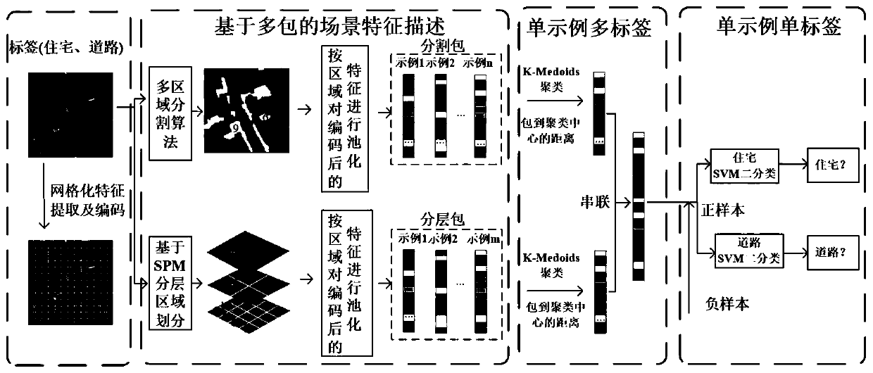
[0080] The present invention provides a more complete description for complex remote sensing scenes, and provides a multi-label classification method for high-resolution remote sensing image scenes based on multi-packet fusion. The block diagram is as follows figure 1 shown.

[0081] In this embodiment, according to the form of SIRI-WHU and UC-Merced single-label data sets, on the basis of single labels such as farmland, forest, and residential buildings, the areas that are easy to mix with other scenes to form complex scenes are analyzed from Google Maps. Intercepting and making a multi-label classification experiment data set, the data set contains a total of 637 pictures, each picture size is 320×320 pixels, including forest, residential area, farmland, road, sparse residential and river 6 types of labels, and in More than...


PUM


Abstract

The invention discloses a high-resolution remote sensing image scene multi-label classification method based on multi-packet fusion. The method comprises the following steps: firstly, extracting multiple heterogeneous features on a high-resolution remote sensing image according to grid division and performing encoding; secondly, dividing sub-regions through a layering method and a segmentation method to pool the coded features, and obtaining a layering example package and a segmentation example package; using Mahalanobis distance to cluster the packets by a K-Medoids method, solving distancesfrom the packets to all clustering centers, and forming vectors by all distance values, so as to convert a multi-instance packet into a single instance; carrying out series fusion on the obtained single examples; and finally, designing a plurality of binary classifiers through a pair of other methods to solve the multi-label problem. According to the multi-packet fusion-based high-resolution remote sensing image scene multi-label classification method provided by the invention, the classification performance is improved, and a more excellent classification result is obtained compared with an existing classification method.

Description

technical field [0001] The invention belongs to the technical field of image processing and pattern recognition, and in particular relates to a multi-label classification method for high-resolution remote sensing image scenes based on multi-packet fusion. Background technique [0002] With the continuous deepening of people's research, remote sensing image classification technology has made significant progress. However, the previous research on classification technology is often based on a single label. This classification method has the advantage of being simple and clear, but at the same time there are also incomplete The downside of describing image content. In recent years, many researchers have also begun to realize this situation, and introduced the idea of ​​multi-label classification to solve such problems, one of which is called Multi-Instance Multi-Label learning (Multi-InstanceMulti-Label learning, MIML). Frames in particular attract attention. In MIML, an imag...

Claims


Application Information

Patent Timeline
Patent Type & Authority Applications(China)
IPC IPC(8): G06K9/62G06K9/00G06K9/34
CPCG06V20/13G06V10/26G06F18/23213G06F18/213G06F18/2411G06F18/214G06F18/253
Inventor 王鑫熊星南石爱业吕国芳宁晨
Owner HOHAI UNIV
Why Eureka
Try Eureka