Method for extracting center-line airborne geophysical prospecting data extraction method of curved railway tunnel

A technology of tunnel centerline and aerial geophysical prospecting, which is applied in the direction of special electromagnetic/magnetic detection during transportation, can solve the problem of inability to obtain the aerial geophysical prospecting data of the tunnel centerline, and achieve the effect of accurate acquisition.

Active Publication Date: 2019-10-08
核工业航测遥感中心 +1
View PDF3 Cites 7 Cited by
  • Summary
  • Abstract
  • Description
  • Claims
  • Application Information

AI Technical Summary

Problems solved by technology

[0004] The object of the present invention is to provide a method for extracting aerial geophysical survey data of the center line of a curved railway tunnel, so as to solve the problem that the r

Method used


Image

  • Method for extracting center-line airborne geophysical prospecting data extraction method of curved railway tunnel
  • Method for extracting center-line airborne geophysical prospecting data extraction method of curved railway tunnel
  • Method for extracting center-line airborne geophysical prospecting data extraction method of curved railway tunnel

Examples


Embodiment Construction

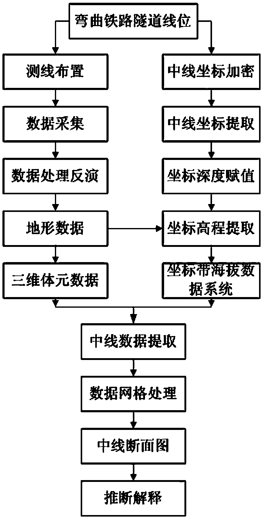
[0033] Such as figure 1 Shown, the steps of the present invention include:

[0034] a. Arrange area-based aerial object detection lines, the control width of which is equal to or slightly greater than the coverage width of the tunnel centerline;

[0035] b. Acquisition of airborne geophysical prospecting data along the arranged survey line;

[0036] c. Perform inversion processing on the obtained airborne geophysical prospecting data, and obtain survey line aerial geophysical prospecting inversion data;

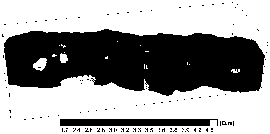
[0037] d. Carry out grid difference processing on the obtained aerial geophysical survey line inversion data, and obtain the aerial geophysical prospecting 3D voxel data of the curved railway tunnel section;

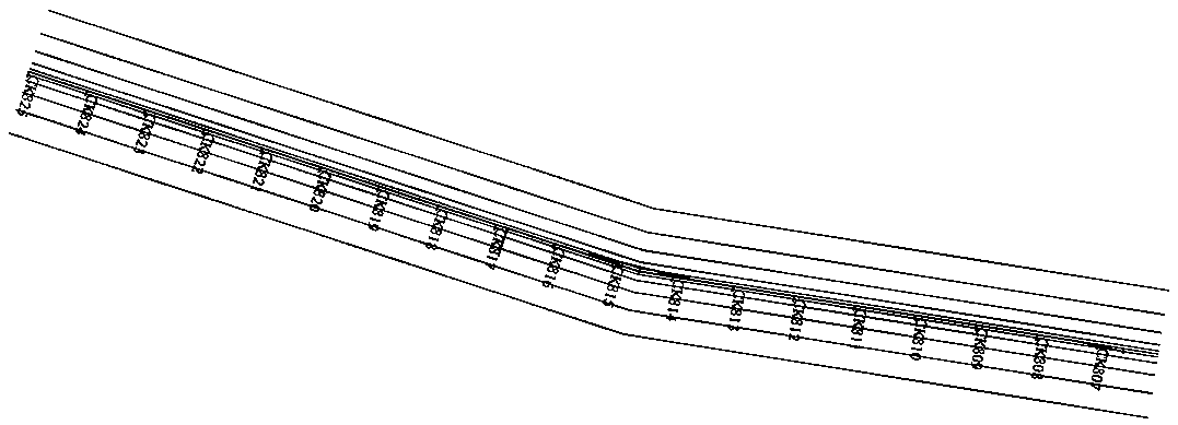
[0038] e. Equally spaced interpolation or equidistant division of the tunnel centerline, and extraction of each coordinate point of the tunnel centerline;

[0039] f. According to the measurement data of airborne geophysical survey, extract the altitude data correspo...


PUM


Abstract

The invention relates to a method for extracting center-line airborne geophysical prospecting data extraction method of a curved railway tunnel. On the basis of area-based aerial measurement on curvedrailway tunnel sections one by one, inversion is performed to obtain airborne geophysical prospecting inversion data of each survey line; meshed interpolation calculation is performed on the inversion data to obtain three-dimensional voxel data of the curved railway tunnel; equal-interval interpolation or equal-interval segmentation is performed on the center line of the tunnel to obtain a plurality of tunnel center-line coordinate points; on the basis of the airborne geophysical prospecting data, altitude elevation data of each tunnel center line coordinate point are extracted; depth assignment is carried out on the all tunnel center line coordinate points; a tunnel center line altitude coordinate system is generated by using landform altitude data of the corresponding coordinate points;and then airborne geophysical prospecting data information of the tunnel center lines are extracted from the tunnel three-dimensional voxel data to obtain a tunnel center line airborne geophysical prospecting cross-section diagram. Therefore, tunnel center line airborne geophysical prospecting data information can be obtained rapidly and accurately, so that an accurate analysis result is obtained.

Description

technical field [0001] The invention relates to an engineering geological survey technology, in particular to a method for extracting airborne geophysical survey data of the center line of a curved railway tunnel. Background technique [0002] The purpose of engineering survey is mostly to find out the distribution characteristics of unfavorable geological bodies along the strike direction of the railway, especially for railway tunnel survey. Railway tunnel survey usually adopts controlled source audio magnetotelluric method, audio frequency magnetotelluric measurement method (AMT) or magnetotelluric measurement method (MT) and other methods, and the corresponding measurement tasks can be completed by measuring along the direction of the railway tunnel. However, in complex alpine mountains or forest swamp areas, due to the complex terrain, landform, high cold and hypoxia, etc., it is difficult to obtain good results by conventional survey methods, and there may even be a lar...

Claims


Application Information

Patent Timeline
IPC IPC(8): G01V3/16
CPCG01V3/16
Inventor 王志宏李怀渊江民忠孙栋华彭莉红骆燕程莎莎李寿华占美炎陈伟
Owner 核工业航测遥感中心
Why Eureka
Try Eureka