Street view image-oriented ground state correction model space-time organization and retrieval method and device

A technology for correcting models and images, which is applied in the field of geographic information, can solve the problems of unaccounted for street view images and small space-time differences, and achieve the effects of improving convenience, reducing data redundancy, and improving update efficiency

Pending Publication Date: 2019-10-22
BEIJING UNIV OF CIVIL ENG & ARCHITECTURE
View PDF7 Cites 0 Cited by
  • Summary
  • Abstract
  • Description
  • Claims
  • Application Information

AI Technical Summary

Problems solved by technology

[0003] The present invention provides a ground state correction model space-time organization, search method and device for street view images, which solves the problem that the search optimization method for street view images in the prior art does not consider the characteristics of all elements of space-time street view images and small spatio-temporal differences, and Technical Problems of Correlation with Typical Urban Feature Elements

Method used


Image

  • Street view image-oriented ground state correction model space-time organization and retrieval method and device
  • Street view image-oriented ground state correction model space-time organization and retrieval method and device
  • Street view image-oriented ground state correction model space-time organization and retrieval method and device

Examples


Embodiment 1

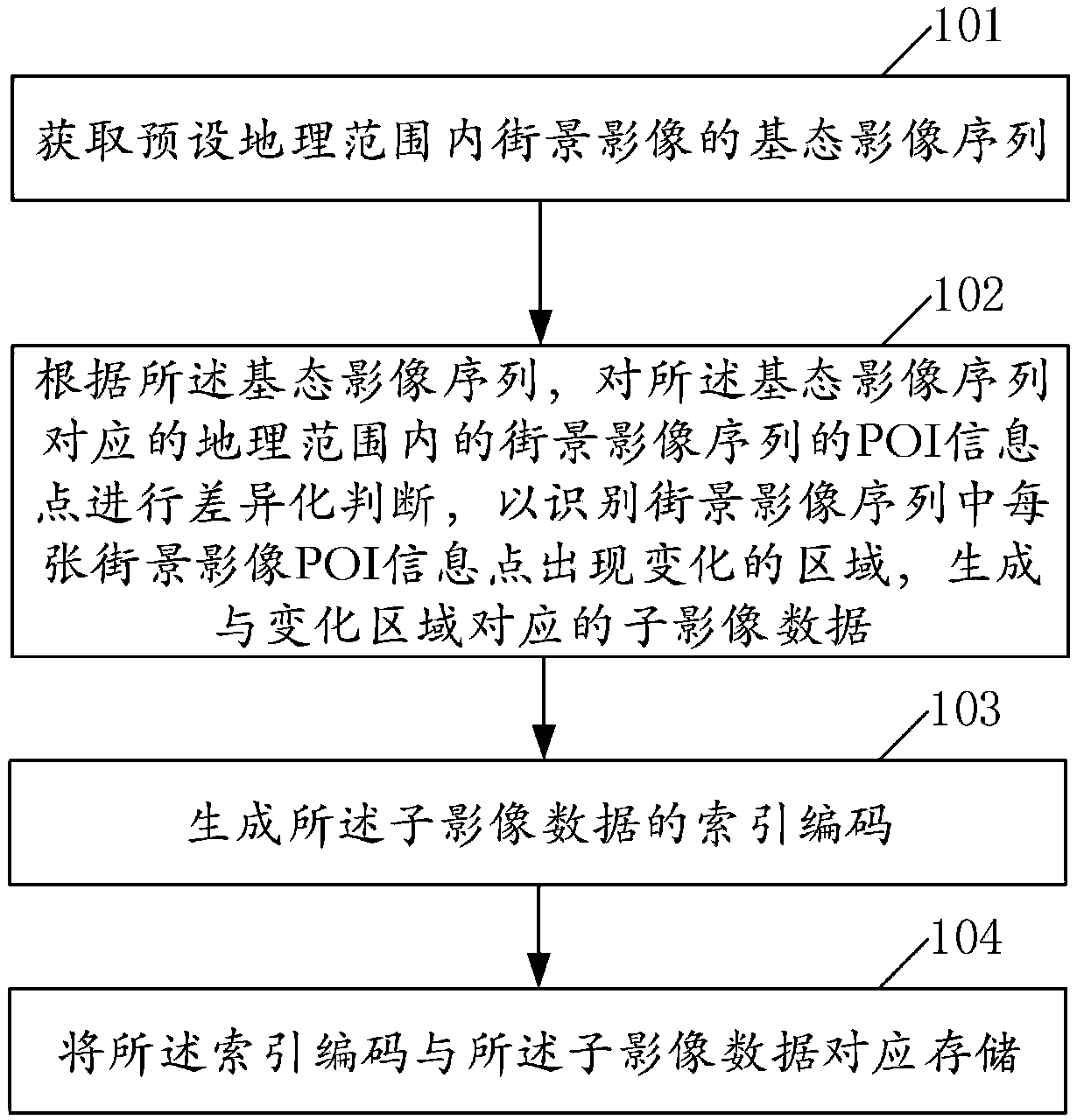
[0034] Embodiment 1 of the present invention provides a ground state correction model space-time organization method for street view images, such as figure 1 shown, including:

[0035] Step 101. Obtain a base state image sequence of street view images within a preset geographical range;

[0036] Wherein, the base state image sequence is a corresponding street view image sequence when the geographical range is in a relatively stable state. The base state image sequence represents an initial state, and the present invention defines the base state image sequence as a street view image sequence when the urban landscape is in a relatively stable state (for example, the state without large-scale construction). The geographic range can be an area (including multiple streets and road sections) or a road section.

[0037] Step 102: According to the base state image sequence, differentiate the POI information points of the street view image sequence within the geographical range corre...

Embodiment 2

[0054] Embodiment 2 of the present invention provides a ground state correction model space-time retrieval method for street view images, such as Figure 5 shown, including:

[0055] Step 501, obtaining query parameters;

[0056] Wherein, the query includes street view image sequence identification and time information;

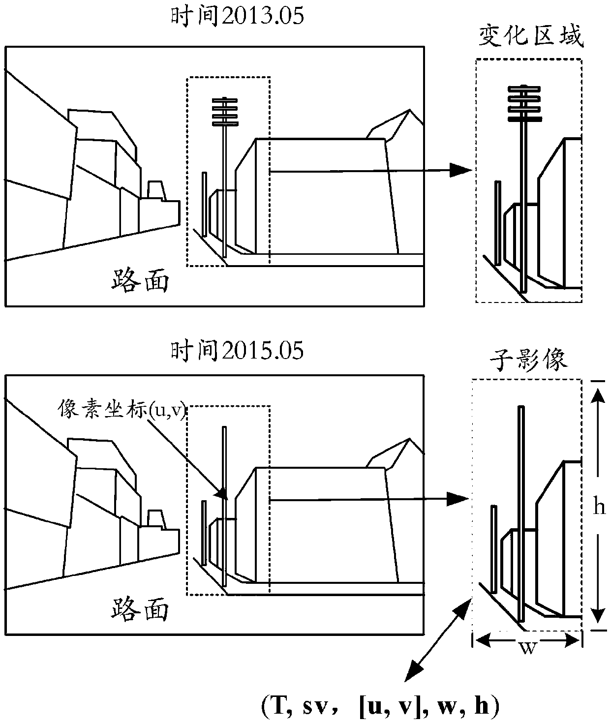
[0057] Step 502. Obtain the corresponding base state image sequence and base state difference image sequence according to the query parameters;

[0058] Wherein, the base-state difference image sequence is a series of sub-image data of POI information points that have changed relative to the base-state image sequence, wherein the sub-image data is related to the street view image sequence identification, the time information of the street view image corresponding to the change area, and the change area The number, the pixel coordinates of the center point of each change area in the corresponding street view image, and the size of each change area are stored...

Embodiment 3

[0062] Embodiment 3 of the present invention provides a ground state correction model space-time organization device for street view images, such as Image 6 mentioned, including:

[0063] An acquisition module 610, configured to acquire a base state image sequence of street view images within a preset geographical range, wherein the base state image sequence is a corresponding street view image sequence when the geographical range is in a relatively stable state;

[0064] Calculation module 620, configured to perform differentiated judgment on POI information points of street view image sequences within the geographical range corresponding to the base state image sequence according to the base state image sequence, so as to identify POI information points of each street view image in the street view image sequence In the area where the change occurs, generate sub-image data corresponding to the changed area;

[0065] The index module 630 is used to generate the index code of...


PUM


Abstract

The invention relates to the technical field of geographic information, and discloses a street view image-oriented ground state correction model space-time organization and retrieval method and device, and the method comprises the steps: obtaining a ground state image sequence of street view images in a preset geographic range; according to the ground state image sequence, carrying out differentiation judgment on POI information points of a streetscape image sequence in a geographic range corresponding to the ground state image sequence so as to identify a changed region of each streetscape image POI information point in the streetscape image sequence, and generating sub-image data corresponding to the changed region; generating an index code of the sub-image data; and correspondingly storing the index code and the sub-image data. According to the invention, the street view image space-time unified storage of POI information points is realized, and the historical street view data queryconvenience and POI information point query accuracy are improved. According to the invention, the data storage structure of the multi-period space-time streetscape image is optimized, the data redundancy is reduced, and the space-time data updating efficiency of the urban streetscape is improved.

Description

technical field [0001] The invention relates to the technical field of geographic information, in particular to a ground state correction model space-time organization, retrieval method and device for street view images. Background technique [0002] Street view image is a kind of all-element information of urban landscape collected based on mobile platform. It is an information model of urban landscape and has been widely used in urban planning, urban management, surveying and mapping, land, transportation and other industries. Street view images collected in multiple periods have high similarity and large data redundancy, resulting in low data retrieval efficiency. In view of the above problems, in the prior art, various new retrieval algorithms are mainly used to improve the retrieval efficiency. However, the prior art does not take into account the characteristics of all elements of the space-time street view image, the small space-time difference, and the contrast rela...

Claims


Application Information

Patent Timeline
Patent Type & Authority Applications(China)
IPC IPC(8): G06F16/29G06F16/53
Inventor 靖常峰杜明义
Owner BEIJING UNIV OF CIVIL ENG & ARCHITECTURE
Why Eureka
Try Eureka