GNSS/inertia/lane line constraint/speedometer multi-source fusion method

A fusion method and lane line technology, applied in road network navigator, radio wave measurement system, satellite radio beacon positioning system, etc., can solve the problems of complex and changeable urban environment, difficult to predict, etc., and achieve convenient application and low cost , The effect of high positioning reliability

Active Publication Date: 2019-11-05
WUHAN UNIV
View PDF4 Cites 22 Cited by
  • Summary
  • Abstract
  • Description
  • Claims
  • Application Information

AI Technical Summary

Problems solved by technology

However, the urban environment is complex and changeable, and it is difficult to predict. In the case of a large amount of uncertainty and incomplete knowledge, autonomous driving is facing huge risks.

Method used


Image

  • GNSS/inertia/lane line constraint/speedometer multi-source fusion method
  • GNSS/inertia/lane line constraint/speedometer multi-source fusion method
  • GNSS/inertia/lane line constraint/speedometer multi-source fusion method

Examples


Embodiment Construction

[0054] In order to make the objectives, technical solutions, and advantages of the present invention clearer, the following further describes the present invention in detail with reference to the accompanying drawings and embodiments. It should be understood that the specific embodiments described here are only used to explain the present invention, but not to limit the present invention.

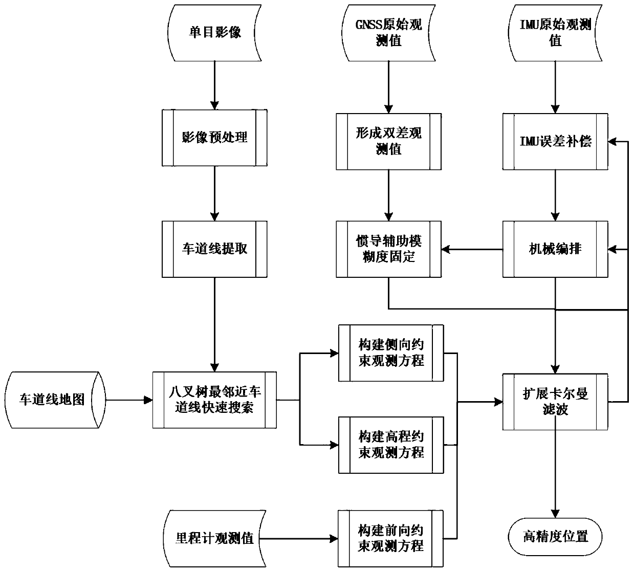
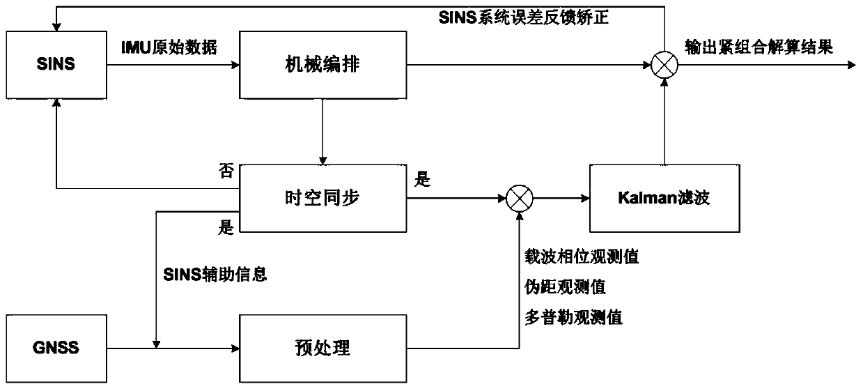
[0055] The overall filtering framework of the present invention is GNSS / INS tight combination extended Kalman filtering, and the tight combination structure is as figure 2 As shown, the navigation coordinate system is selected as the ECEF system, and the corresponding SINS mechanical arrangement is also carried out under the ECEF system. In the tight combination, the original observations of GNSS and SINS are jointly input into a Kalman filter to jointly estimate navigation parameters (position, velocity and attitude), SINS system error and GNSS related parameters (ambiguity), and adopt closed...


PUM


Abstract

The invention discloses a GNSS / inertia / lane line constraint / speedometer multi-source fusion method. According to the method, a visual sensor is utilized to generate a lane line map database offline based on a visual and crowdsourcing mode; when a carrier performs real-time navigation and positioning calculation, the visual sensor mounted on the carrier detects a relative relation between the carrier and a lane line with a differential GNSS / INS tight combination adopted as a basis under a condition that the GNSS is seriously blocked; under the assistance of a lane line map, a lane line constraint observation equation is dynamically added for auxiliary positioning, so that position divergence in a lateral direction and an elevation direction is effectively inhibited; a speed observation value in the advancing direction of a vehicle and observation satellites above the carrier and in forward direction of a road are provided through a wheeled speedometer, and therefore, the forward error of the carrier is remarkably decreased. With the GNSS / inertia / lane line constraint / speedometer multi-source fusion method of the invention adopted, position error drift in three directions can be effectively controlled in a typical urban dynamic complex environment. The method is an effective scheme for realizing centimeter-level positioning in an urban complex environment.

Description

Technical field [0001] The invention relates to the field of integrated navigation, in particular to a GNSS / inertial / lane line constraint / odometer multi-source fusion method. Background technique [0002] With the completion and operation of the regional service system of my country's Beidou satellite navigation system, the modernization of GPS in the United States and GLONASS in Russia, and the construction of Galileo in the European Union, QZSS in Japan, and IRNSS in India, GNSS (GNSS, Global Navigation Satellite System) is becoming a multi-frequency and multi-system The direction is booming. Then, due to the three major vulnerabilities of GNSS, including occlusion, interference and deception, it is unable to provide reliable and continuous positioning services in complex environments. Therefore, the integration of a variety of different navigation systems and sensors, fusion of all available signal sources, plug-and-play all-source positioning and navigation is proposed, aimin...

Claims


Application Information

Patent Timeline
Patent Type & Authority Applications(China)
IPC IPC(8): G01C21/28G01S19/48
CPCG01C21/28G01S19/48
Inventor 张小红沈燕芬朱锋贾俊
Owner WUHAN UNIV
Why Eureka
Try Eureka