
Method for extracting urban road on remote sensing images based on road intersection detection

A remote sensing image and road extraction technology, applied in the direction of basic element extraction, image enhancement, image analysis, etc., can solve problems such as road surface spectrum and texture abnormalities, affecting identification and extraction work, and achieve high accuracy

Inactive Publication Date: 2019-11-12
CHONGQING GEOMATICS & REMOTE SENSING CENT +1
View PDF4 Cites 4 Cited by
  • Summary
  • Abstract
  • Description
  • Claims
  • Application Information

AI Technical Summary

Problems solved by technology

In addition, the rich details of the road surface, such as cars, isolation belts, etc., lead to abnormal road surface spectra and textures, which seriously affect the recognition and extraction work

Method used


Image

  • Method for extracting urban road on remote sensing images based on road intersection detection
  • Method for extracting urban road on remote sensing images based on road intersection detection
  • Method for extracting urban road on remote sensing images based on road intersection detection

Examples


Embodiment Construction

[0041] The specific implementation manner and working principle of the present invention will be further described in detail below in conjunction with the accompanying drawings.

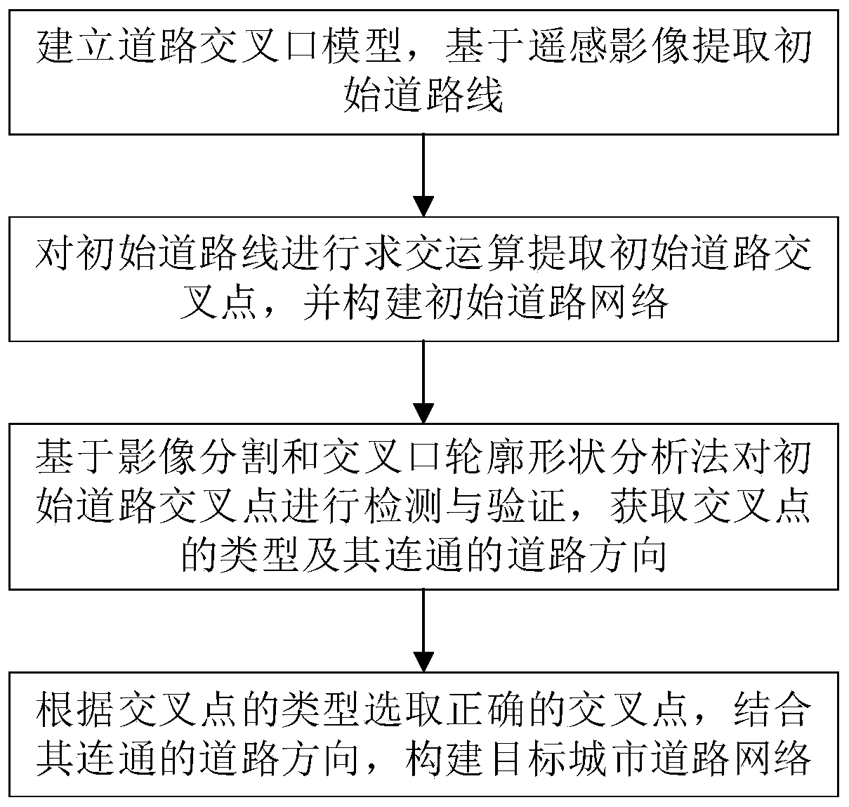
[0042] Such as figure 1 As shown, a method for extracting urban roads from remote sensing images based on road intersection detection, the main steps include automatically extracting vector road lines from remote sensing image data as initial values ​​to obtain initial road lines; extracting key points from the initial road lines, including Intersections with connected road directions and shape key points, through the detection and verification of intersections, the type of intersection and the direction of the road are obtained, and the required target urban road network is constructed. The specific steps are as follows:

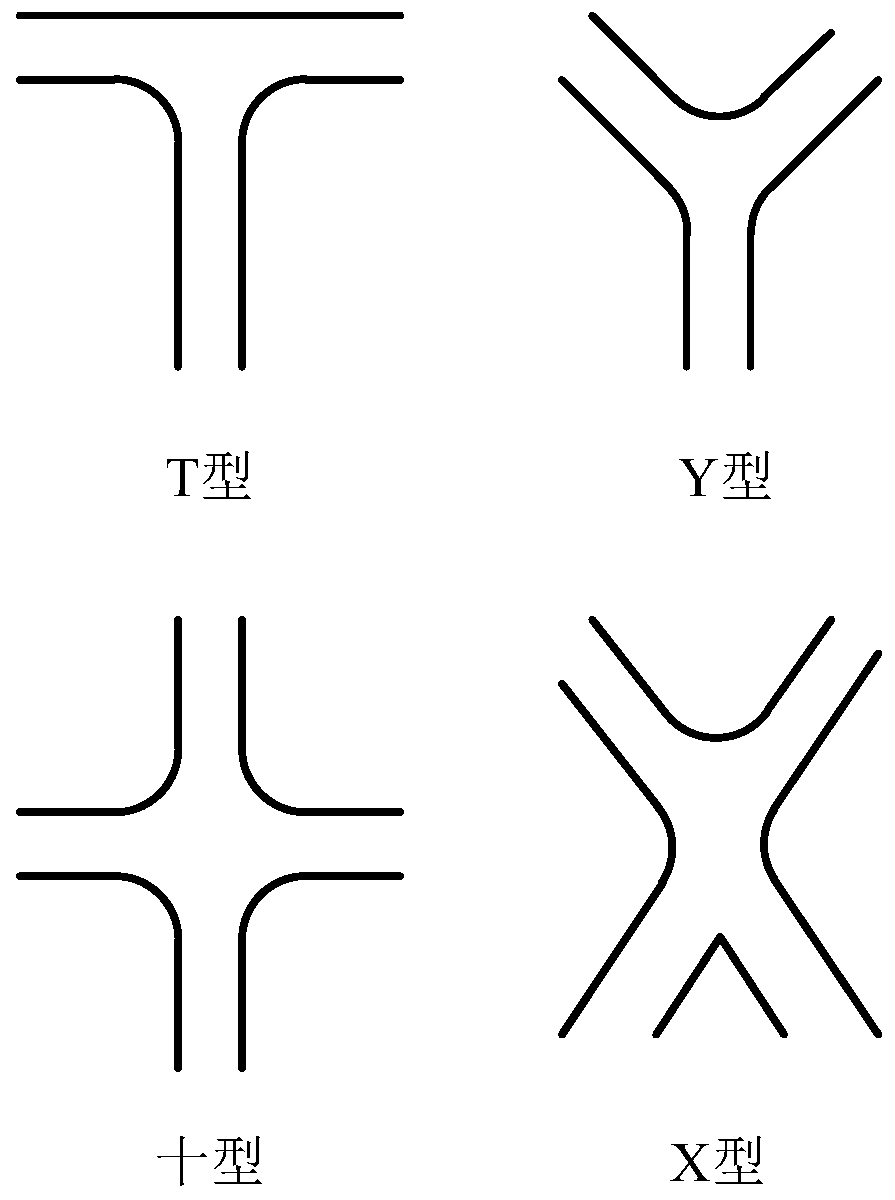
[0043] First enter step 1: build a road intersection model, such as figure 2 As shown, they are T-type, Y-type, Ten-type, and X-type respectively. The data structure contained i...


PUM


Abstract

The invention discloses a method for extracting an urban road on a remote sensing image based on road intersection detection, which comprises the following steps: establishing a road intersection model, and extracting an initial road line based on the remote sensing image; performing intersection operation on the initial road lines to extract initial road intersection points, and constructing an initial road network; detecting and verifying the initial road intersection based on an image segmentation and intersection contour shape analysis method, and obtaining the type of the intersection andthe direction of a road communicated with the intersection; and selecting correct intersections according to the types of the intersections, and constructing a target city road network in combinationwith the connected road directions. The method has the advantages that the urban road is extracted based on the road intersection, a stable and reliable extraction result is provided for urban road network extraction, the integrity and accuracy are higher, and the defects that in the prior art, an algorithm does not have universality, and the requirements for road characteristics and ground object conditions are high are effectively overcome.

Description

technical field [0001] The invention relates to the technical field of remote sensing image information extraction, in particular to a method for extracting urban roads from remote sensing images based on road intersection detection. Background technique [0002] As an important hub in geographic information, roads are closely related to the construction of various industries such as transportation, water conservancy, urban planning, electric power, emergency response, and energy. The identification and extraction of roads has been an important research topic in the past two decades, and extracting road networks from urban areas is an unsolved problem. [0003] Many scholars have achieved varying degrees of results in road extraction research, especially in the extraction of suburban roads from low- and medium-resolution remote sensing images. There are many mature and robust algorithms and strategies. However, compared to rural areas with few ground features and obvious ro...

Claims


Application Information

Patent Timeline
IPC IPC(8): G06T7/11G06T7/136G06T7/149G06T7/543G06T11/20G06K9/46
CPCG06T7/149G06T7/11G06T7/136G06T7/543G06T11/203G06T2207/10032G06V10/462
Inventor 胡艳李朋龙连蓉王亚林张泽烈徐永书李怡静胡翔云丁忆罗鼎段松江吴凤敏王小攀陈静钱进范文武刘建李晓龙郑中谭攀
Owner CHONGQING GEOMATICS & REMOTE SENSING CENT
Learn More