Method for acquiring positioning information of any pixel point of aerial image

A technology for aerial imagery and positioning information, applied in image enhancement, image analysis, image data processing, etc., can solve the problem of low positioning accuracy and achieve the effect of avoiding complexity

Inactive Publication Date: 2019-12-06
CHANGCHUN INST OF OPTICS FINE MECHANICS & PHYSICS CHINESE ACAD OF SCI
View PDF4 Cites 6 Cited by
  • Summary
  • Abstract
  • Description
  • Claims
  • Application Information

AI Technical Summary

Problems solved by technology

[0003] In order to solve the problem of low positioning accuracy existing in the target positioning of aerial images of unmanned aerial vehicles, the present invention provides a method for obtaining positioning information of each pixel of aerial images

Method used


Image

  • Method for acquiring positioning information of any pixel point of aerial image
  • Method for acquiring positioning information of any pixel point of aerial image
  • Method for acquiring positioning information of any pixel point of aerial image

Examples


specific Embodiment approach 1

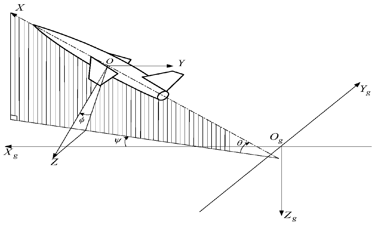
[0038] Specific implementation mode 1. Combination Figure 1 to Figure 3 Describe this embodiment, a method for obtaining the positioning information of each pixel point of an aerial image, through the flight attitude information given by the inertial navigation system, perform orthorectification on the aerial image, and then use the longitude and latitude information of the shooting point given by the inertial navigation system to calculate Obtain the positioning information of each pixel point on the aerial image, that is, the latitude and longitude coordinate information. Specifically, it is realized by the following steps:

[0039] 1. Establish a coordinate system;

[0040] Such as figure 1 As shown, first establish the ground coordinate system O g -X g Y g Z g , the origin is O g , X g The positive direction of the axis points to the geographic true north direction, Z g The positive direction of the axis is perpendicular to the ground plane downward, Y g The pos...


PUM


Abstract

The invention discloses a method for acquiring positioning information of any pixel point of an aerial image, relates to the technical field of photoelectric imaging and solves the problem of low positioning accuracy when target positioning is performed on the aerial image of an unmanned aerial vehicle. The method comprises three steps: establishing a coordinate system; obtaining the aerial imageaccording to an aerial photography system of an aircraft; and according to flight attitude information provided by an inertial navigation system, carrying out ortho-rectification on the aerial image and solving longitude and latitude of any point on the image. The method effectively avoids the problem of complexity of the binocular stereo vision positioning technology and solves the problem of lowpositioning precision of a monocular camera, can accurately obtain longitude and latitude positioning information of any point on the image and lays a foundation for application of the aerial photography system in disaster rescue, territorial supervision, resource investigation, military investigation and the like.

Description

technical field [0001] The invention relates to the technical field of photoelectric imaging, in particular to a method for acquiring positioning information of each pixel of an aerial image. Background technique [0002] With the continuous development of UAV technology, UAV, as an important tool of the new generation, has been widely used in disaster relief, land surveillance, environmental protection, resource investigation, military investigation, etc. Among them, the use of aerial images of UAVs for target positioning has become a research hotspot in the field of UAVs. Based on the binocular stereo vision monitoring target positioning technology to calculate the position of the positioning target, the target positioning based on a single camera uses multiple Conversion between two coordinate systems to obtain the coordinate information of the target point in the camera coordinate system in the ground coordinate system. Due to the complex environment of the UAV during f...

Claims


Application Information

Patent Timeline
Patent Type & Authority Applications(China)
IPC IPC(8): G01C11/04G06T7/70G06T7/80G06T5/00
CPCG01C11/04G06T5/006G06T2207/10032G06T7/70G06T7/80
Inventor 毕国玲张星祥聂婷余达张艳超
Owner CHANGCHUN INST OF OPTICS FINE MECHANICS & PHYSICS CHINESE ACAD OF SCI
Why Eureka
Try Eureka