Indoor position service-oriented navigation network construction method

An indoor location and network construction technology, applied in the field of indoor maps, can solve the problems of low efficiency of construction methods and lack of indoor navigation network information.

Active Publication Date: 2019-12-06
NANJING FORESTRY UNIV
View PDF4 Cites 20 Cited by
  • Summary
  • Abstract
  • Description
  • Claims
  • Application Information

AI Technical Summary

Problems solved by technology

[0004] In view of the above-mentioned defects, the purpose of the present invention is to provide a navigation network construction method oriented to indoor location services, in order to solve the problems of lack of indoor navigation network information and low construction efficiency in the prior art

Method used


Image

  • Indoor position service-oriented navigation network construction method
  • Indoor position service-oriented navigation network construction method

Examples


Embodiment 1

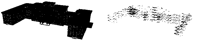
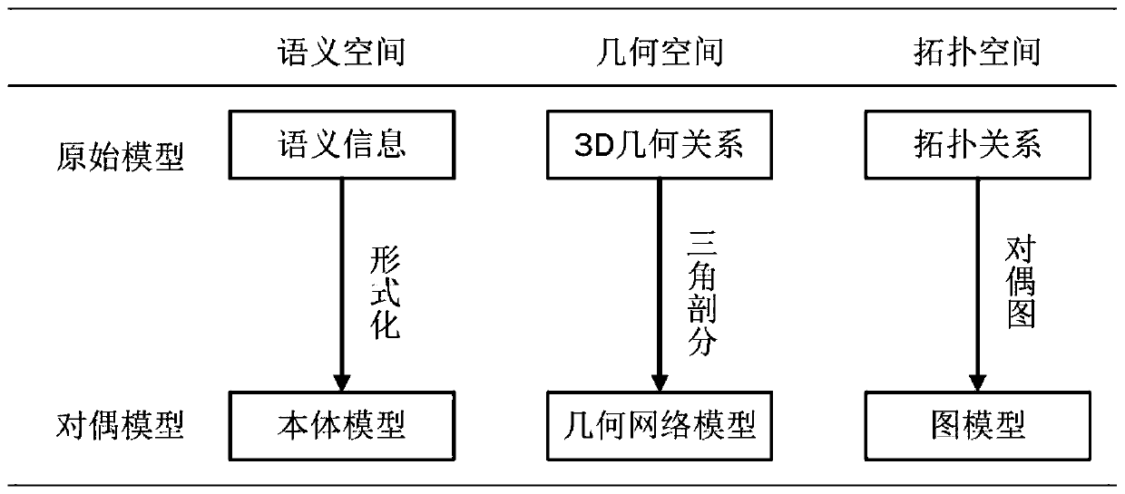
[0038] S1: Import the BIM building model of the target building in IFC format, and obtain the original model that can be applied to indoor location services through 3D visualization;

[0039] S2: Use semantic filtering to extract semantic information in IFC, and construct an ontology model through formalization;

[0040] S3: Convert the topological relationship in the original model into a graph model in the form of a dual graph;

[0041] S4: Extract the geometric information of structural parts such as rooms, columns, walls, stairs, and indoor facilities such as furniture in the BIM model, construct constrained boundaries, use the limited Delaunay triangulation refinement algorithm for spatial division, and construct a geometric network model;

[0042] S5: Synthesize ontology model, graph model and geometric model data to form a navigation network for indoor location services.

[0043] Specifically in this embodiment, the step S1 specifically includes:

[0044] S11 Open the...


PUM


Abstract

The invention provides an indoor position service-oriented navigation network construction method, which comprises the following steps of S1, importing a BIM building model in a target building IFC format, and obtaining an original model capable of being applied to indoor position service through three-dimensional visualization; S2, extracting semantic information in IFC through semantic filtering, and constructing an ontology model in a formalized mode; S3, in the form of a dual graph, converting the topological relation in the original model into a graph model; S4, extracting geometric information of structural components such as rooms, columns, walls and stairs and indoor facilities such as furniture in the BIM model, constructing constraint boundaries, performing spatial subdivision through a limited Delaunay triangulation refinement algorithm, and constructing a geometric network model; and S5, integrating the ontology model, the graph model and the geometric model data to form anavigation network for indoor position service. Based on BIM model data, a dual model is established by extracting semantic information, geometric information and a topological relation, and a construction method considering a real indoor environment navigation geometric network is explored.

Description

technical field [0001] The invention relates to the field of indoor maps, in particular to a navigation network construction method for indoor location services. Background technique [0002] With the rise of indoor positioning technology in recent years, location-based service (Location-based Service, LBS) has also begun to expand from outdoors to indoors. Indoor navigation network is the basic element of indoor LBS, but due to the limitation of indoor topology, the indexing technology of outdoor geometric space cannot be directly applied to indoor geometric space. A major feature of LBS that distinguishes it from other traditional network services is context awareness and adaptability to context changes. Building Information Modeling (BIM) is a digital representation of all physical and functional characteristics of a building throughout its life cycle. With the gradual popularization of BIM technology, BIM based on IFC standards has become an important data source for in...

Claims


Application Information

Patent Timeline
Patent Type & Authority Applications(China)
IPC IPC(8): G06F17/50G06T17/05G06T17/10G06T17/20G01C21/20
CPCG01C21/206G06T17/05G06T17/10G06T17/20
Inventor 郑加柱张炜锴
Owner NANJING FORESTRY UNIV
Why Eureka
Try Eureka