Simulation method of multi-model flexible architecture based on basin fine classification

A fine classification and simulation method technology, applied in the field of watershed flood simulation, can solve the problems of single runoff model, difficult model selection, and different calculations, and achieve the effect of improving accuracy

Active Publication Date: 2020-03-27
HOHAI UNIV
View PDF4 Cites 8 Cited by
  • Summary
  • Abstract
  • Description
  • Claims
  • Application Information

AI Technical Summary

Problems solved by technology

There are many types of models and different calculations. In the process of practical application, the selection of models is a difficult problem, and there are huge uncertainties.
In addition, the traditional conceptual model has a single runoff model, which cannot describe the complex physical process of runoff formation in this area.

Method used


Image

  • Simulation method of multi-model flexible architecture based on basin fine classification
  • Simulation method of multi-model flexible architecture based on basin fine classification
  • Simulation method of multi-model flexible architecture based on basin fine classification

Examples


Embodiment example

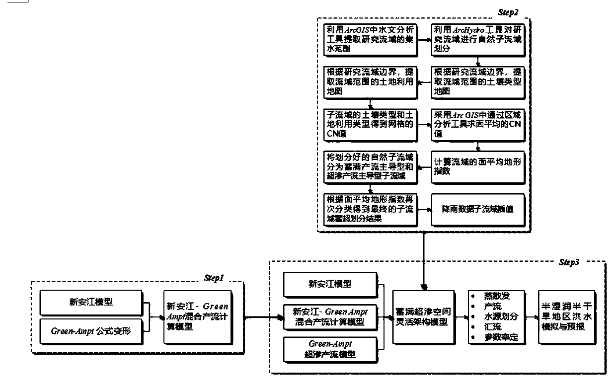
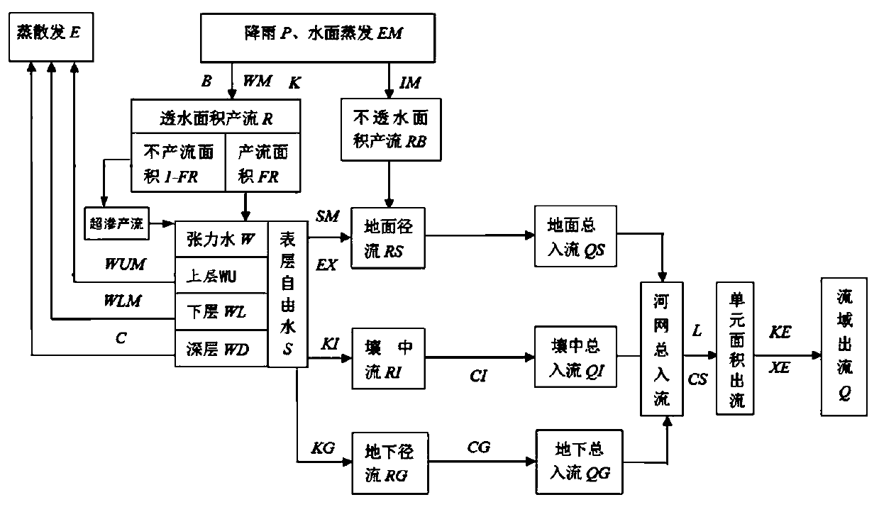
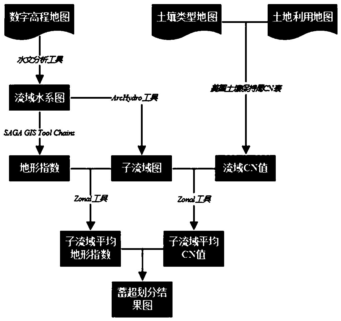
[0134] Taking the Dongwan River Basin in Henan Province as an example, the Dongwan River Basin is located in the source area of ​​the Yihe River, at 111°59' east longitude and 34°03' north latitude, with a drainage area of ​​2856km 2 . The distribution of rainfall is uneven. The precipitation in the watershed is between 500-1100mm, and the annual precipitation increases with the increase of terrain height. The annual water surface evaporation is between 1000-1300mm, which belongs to the semi-arid and semi-humid area. The daily precipitation of heavy rain is generally more than 100mm, and the big one can reach 400-600mm. Heavy rain generally occurs between May and October, and July-August accounts for 60-80% of the total. The climate type of this basin belongs to warm temperate continental monsoon climate zone and mountain monsoon climate, with cold and dry winter and hot and rainy summer. The annual precipitation increases with the height of the terrain. Mountains are rainy a...


PUM


Abstract

The invention provides a simulation method of a multi-model flexible architecture based on basin fine classification. The simulation method comprises the following steps: S1, constructing a Xinanjiang-Green Ampt mixed runoff production calculation model of a semi-humid semi-arid basin; S2, subjecting the semi-humid and semi-arid watershed to infiltration-excess and saturation-excess sub-watersheddivision for fine classification; and S3, constructing a flexible architecture model of the infiltration-excess and saturation-excess space of the semi-humid and semi-arid watershed, and performing calculation. The invention provides a convenient and effective method for forecasting the flood process of the semi-humid and semi-arid region, finely classifies the watershed, provides a more reasonable and reliable simulation method for simulating the flood, and improves the calculation precision of the hydrological model. And meanwhile, the problem of classification of mountainous watersheds in medium and small drainage basins lacking observation data is solved, important basic data is provided for flood forecasting and other aspects of the semi-humid and semi-arid regions, and the scientificity of flood forecasting of the semi-humid and semi-arid regions is enhanced. The method is stable and reliable in data source, high in calculation efficiency and objective and reasonable in result.

Description

technical field [0001] The present invention relates to the field of hydrology technology, specifically a watershed flood simulation method for semi-humid and semi-arid watersheds through fine classification of watersheds and flexible model architecture. Background technique [0002] Flood disaster is one of the most common natural disasters in our country, especially in the semi-humid and semi-arid areas in the north, where the heavy rainfall is frequent and the flood rises and falls steeply. Therefore, flood forecasting becomes particularly important in flood prevention. The watershed in northern my country is basically a semi-humid and semi-arid area. Due to the relatively dry climate, uneven distribution of vegetation types, poor soil water retention capacity, and small infiltration, it is prone to large-scale floods. In the semi-arid and semi-humid regions, the phenomenon of the runoff area of ​​full storage and super-seepage changes with time and space is particularly ...

Claims


Application Information

Patent Timeline
Patent Type & Authority Applications(China)
IPC IPC(8): G06F16/29G06T17/05
CPCG06T17/05Y02A10/40
Inventor 刘玉环罗赟李致家臧帅宏童冰星
Owner HOHAI UNIV
Why Eureka
Try Eureka