An Adaptive Alignment Method in Earth Fixed Coordinate System

A coordinate system and adaptive technology, applied in the field of inertial navigation, can solve the problems of reducing the amount of real-time calculation and large amount of real-time calculation, and achieve the effect of reducing the amount of real-time calculation, small amount of real-time calculation and saving time.

Active Publication Date: 2022-05-03
南京喂啊游通信科技有限公司
View PDF4 Cites 0 Cited by
  • Summary
  • Abstract
  • Description
  • Claims
  • Application Information

AI Technical Summary

Problems solved by technology

[0008] The invention solves the problem: it overcomes the problem that the real-time calculation of the initial alignment in the geographic coordinate system is relatively large in the prior art, and in the fixed earth coordinate system, it provides a method based on additive four The adaptive alignment method of arity can not only achieve fast convergence of alignment, but also help reduce the amount of real-time calculations

Method used


Image

  • An Adaptive Alignment Method in Earth Fixed Coordinate System
  • An Adaptive Alignment Method in Earth Fixed Coordinate System
  • An Adaptive Alignment Method in Earth Fixed Coordinate System

Examples


Embodiment Construction

[0041] The present invention will be described in detail below in conjunction with the accompanying drawings and embodiments.

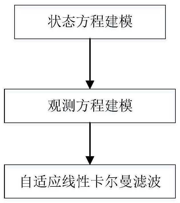
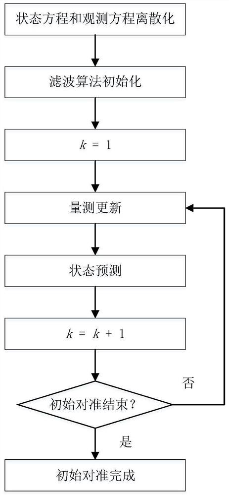
[0042] Such as figure 1 Shown, the present invention is concretely realized as follows:

[0043] (1) State equation modeling

[0044] Taking the earth fixed coordinate system e system as the navigation coordinate system, define is the rotation quaternion from the carrier coordinate system b to the e system (each element is denoted as q 0 ,q 1 ,q 2 ,q 3 ), To calculate the quaternion (each element is denoted as q 0 ,q 1 ,q 2 ,q 3 ), "x" represents the calculated value or real value (including calculation error or measurement error) of any variable x, and "δx" represents the error of any variable x. Define Additive Quaternion Error (Additive Quaternion Error, AQE) as the difference between the calculated quaternion and the real quaternion, recorded as:

[0045]

[0046] Attitude error equation:

[0047]

[0048] in: is the projectio...


PUM


Abstract

The invention relates to an adaptive alignment method under the fixed earth coordinate system, the steps: (1) select the earth fixed coordinate system as the navigation coordinate system, and use the additive quaternion of position error, velocity error and attitude misalignment angle The numerical error is used as the system state variable. (2) The state equation consists of position error equation, linearized velocity error equation and attitude error equation. (3) Using the velocity and position observation information of the GNSS receiver to construct the observation equation. (4) Design an adaptive linear Kalman filter algorithm for initial alignment. The invention does not require static leveling, the amount of real-time calculation is small, the alignment process converges quickly, and the alignment accuracy is high.

Description

technical field [0001] The invention relates to an adaptive alignment method in an earth fixed coordinate system, and belongs to the technical field of inertial navigation. Background technique [0002] Inertial Navigation System (INS) has been widely used because it can provide full navigation information such as attitude, speed and position at the same time, and is completely autonomous and has good anti-interference performance. Especially with the rapid development of microelectronic processing technology, the improvement and price reduction of gyroscopes and accelerometers processed based on MEMS (Micro-Electro-Mechanical System) have laid a solid foundation for the wider application of INS based on MEMS devices. Foundation. [0003] Since the INS is based on the integral working principle, it is necessary to determine the initial attitude, velocity, and position, that is, the initial alignment, before performing a formal navigation calculation. Since the initial velo...

Claims


Application Information

Patent Timeline
Patent Type & Authority Patents(China)
IPC IPC(8): G01C25/00
CPCG01C25/005
Inventor 王可东
Owner 南京喂啊游通信科技有限公司
Why Eureka
Try Eureka