Soil erosion evaluation system

A soil erosion and evaluation system technology, applied in the fields of weather resistance/light resistance/corrosion resistance, resources, instruments, etc., can solve problems such as the integrity and objectivity of impact division, the inability to meet the needs of soil erosion research, and the difficulty of comparing results in time and space

Pending Publication Date: 2020-02-18
INST OF REMOTE SENSING & DIGITAL EARTH CHINESE ACADEMY OF SCI
View PDF1 Cites 3 Cited by
  • Summary
  • Abstract
  • Description
  • Claims
  • Application Information

AI Technical Summary

Problems solved by technology

Soil erosion is affected by various natural and human factors, and the soil erosion intensity is usually determined according to the amount of soil loss per unit area (soil erosion modulus), which is often limited by the layout and distribution density of observation stations, which cannot meet the requirements of a certain area and The nee

Method used


Image

  • Soil erosion evaluation system
  • Soil erosion evaluation system
  • Soil erosion evaluation system

Examples


Embodiment Construction

[0025] The present invention will be further elaborated below in conjunction with the accompanying drawings, but it is not used to limit the scope of the present invention.

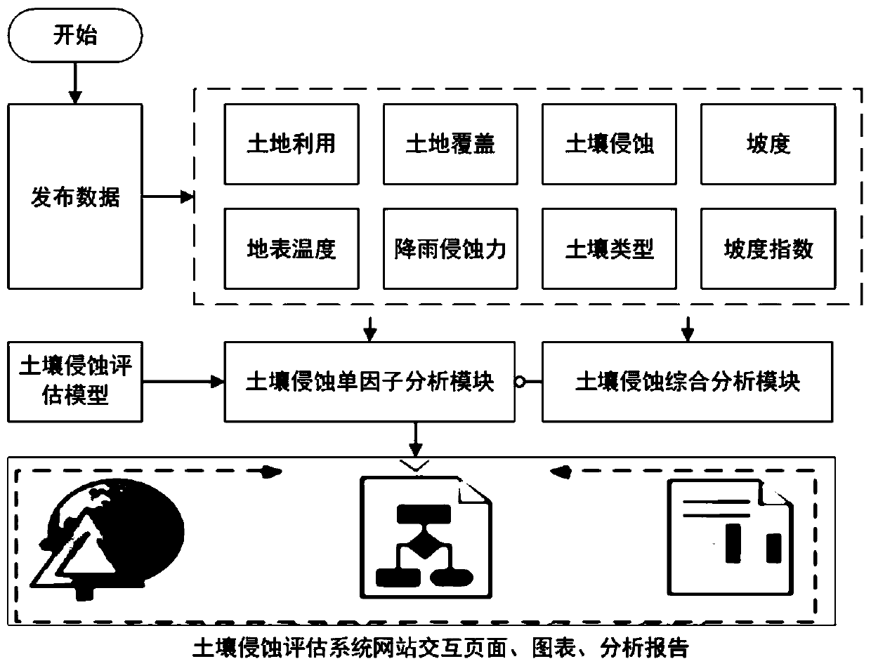
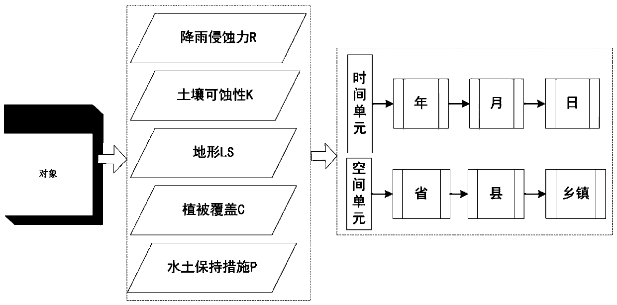
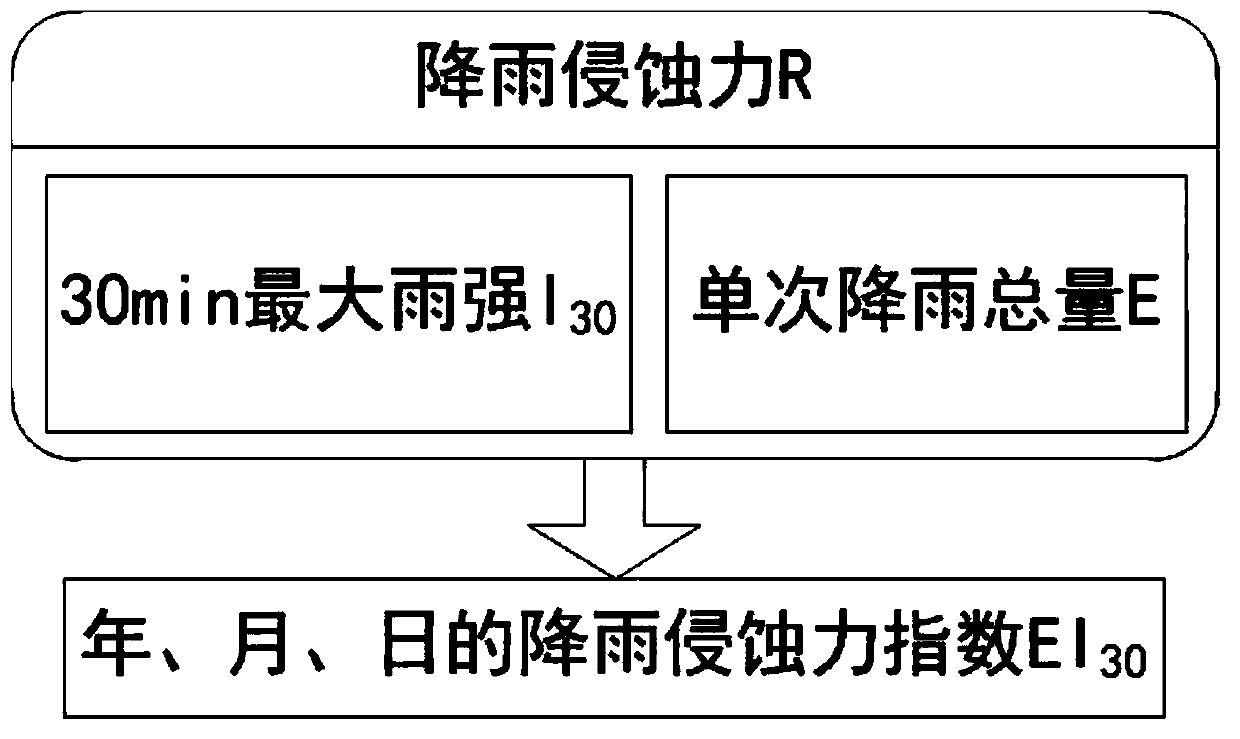
[0026] The embodiment of the present invention relates to an Internet multi-dimensional presentation technology for soil erosion assessment. The technology adopts the AntDesign of Vue interactive language framework, introduces the Viser network drawing class library, and introduces Cesium and OpenLayers map class libraries, which can fully display the rendering effect of multiple information , so as to provide a richer interactive experience and more intuitively show the temporal and spatial distribution of black soil erosion.

[0027] The technology is all developed based on open source framework and open source software, and the specific business logic is completed with the help of geographic information service open source software and graphic visualization class library. Based on the jeecg-boot front-...


PUM


Abstract

The invention provides a soil erosion evaluation system, which mainly comprises a soil erosion single factor analysis module and a soil erosion comprehensive analysis module, and is characterized in that the soil erosion single factor analysis module is used for analyzing a corresponding relationship between each erosion factor and a soil erosion condition; wherein the erosion factors mainly comprise a rainfall erosion force factor, a soil erodibility factor, a terrain factor, a vegetation coverage factor and a water and soil conservation measure factor; and the soil erosion comprehensive analysis module is used for analyzing the weight of each erosion factor and the spatial and temporal distribution of erosion force. According to the method, the soil erosion is evaluated from the multi-dimensional perspective of arbitrary combination of multiple elements influencing the soil erosion, the method can better serve soil erosion mechanism research, and a reference can also be provided forregional resource environment evaluation.

Description

technical field [0001] The invention relates to the related technology of soil erosion evaluation in the field of land degradation, and also relates to the related technology of geographic information display in network information service, which is a comprehensive research and evaluation technology of soil erosion based on network multivariate geographic information service. Background technique [0002] Research progress and characteristics of soil erosion assessment technology: Different from natural erosion or geological erosion, soil erosion refers to the process of accelerating erosion by human activities, resulting in the removal of all or part of the topsoil. The damage of soil erosion to water and soil resources and biological resources is one of the important environmental problems that are generally concerned by countries all over the world. Soil erosion is affected by various natural and human factors, and the soil erosion intensity is usually determined accordin...

Claims


Application Information

Patent Timeline
IPC IPC(8): G06Q10/06G06Q50/02G01N17/00
CPCG06Q10/0639G06Q50/02G01N17/00Y02A40/22
Inventor 胡顺光张增祥汪潇赵晓丽易玲
Owner INST OF REMOTE SENSING & DIGITAL EARTH CHINESE ACADEMY OF SCI
Why Eureka
Try Eureka