
Remote sensing image change detection method and device

A technology for remote sensing image and change detection, applied in instrument, character and pattern recognition, scene recognition and other directions, can solve the problem of low accuracy of remote sensing image change detection, and achieve the effect of improving accuracy and reducing uncertainty.

Active Publication Date: 2020-02-21
UNIV OF SCI & TECH BEIJING
View PDF4 Cites 2 Cited by
  • Summary
  • Abstract
  • Description
  • Claims
  • Application Information

AI Technical Summary

Problems solved by technology

[0003] The technical problem to be solved by the present invention is to provide a remote sensing image change detection method and device to solve the problem in the prior art that the use of a single spectral feature leads to low detection accuracy of remote sensing image changes

Method used


Image

  • Remote sensing image change detection method and device
  • Remote sensing image change detection method and device
  • Remote sensing image change detection method and device

Examples


Embodiment 1

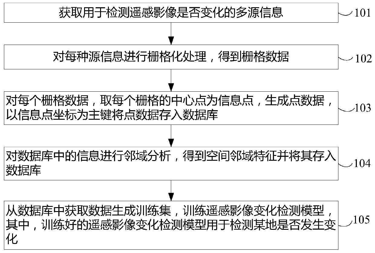
[0055] Such as figure 1 As shown, the remote sensing image change detection method provided by the embodiment of the present invention includes:

[0056]Obtain multi-source information for detecting whether remote sensing images have changed, wherein the multi-source information includes: geographic information, land classification results in automatically marked remote sensing images and remote sensing image change labels, administrative division spatial planning information, manual labeling Land classification results and remote sensing image change labels in remote sensing images;

[0057] S101, performing rasterization processing on each source information to obtain raster data;

[0058] S102, for each grid data, take the center point of each grid as an information point, generate point data, and store the point data in the database with the coordinates of the information point as the primary key;

[0059] S103, performing neighborhood analysis on the information in the ...

Embodiment 2

[0129] The present invention also provides a specific implementation of a remote sensing image change detection device. Since the remote sensing image change detection device provided by the present invention corresponds to the specific implementation of the aforementioned remote sensing image change detection method, the remote sensing image change detection device can perform the above-mentioned The process steps in the specific implementation of the method are used to achieve the purpose of the present invention. Therefore, the explanations in the specific implementation of the remote sensing image change detection method above are also applicable to the specific implementation of the remote sensing image change detection device provided by the present invention. In the present invention Details will not be described in the following specific implementation manners.

[0130] Such as Figure 6 As shown, the embodiment of the present invention also provides a remote sensing i...


PUM


Abstract

The invention provides a remote sensing image change detection method and a remote sensing image change detection device, which can reduce the uncertainty in remote sensing change detection and improve the precision of remote sensing image change detection. The method comprises the steps of obtaining multi-source information used for detecting whether a remote sensing image changes or not; carrying out rasterization processing on each kind of source information to obtain raster data; for each piece of raster data, taking a central point of each raster as an information point, generating pointdata, and storing the point data into a database by taking coordinates of the information points as main keys; carrying out neighborhood analysis on the information in the database to obtain spatial neighborhood features, and storing the spatial neighborhood features into the database; and acquiring data from the database to generate a training set, training a remote sensing image change detectionmodel, wherein the trained remote sensing image change detection model is used for detecting whether a certain place changes or not. The invention relates to the field of remote sensing image changedetection.

Description

technical field [0001] The invention relates to the field of remote sensing image change detection, in particular to a remote sensing image change detection method and device. Background technique [0002] In the early days of remote sensing, change detection has become one of the application areas that people generally pay attention to. With the development of computers, satellite sensors, information processing and other technologies in recent decades, remote sensing image change detection has received a lot of research and made significant progress in terms of theoretical system, technical methods, and application fields. In terms of methods, it includes algebraic method, transformation method, model method and other methods. These methods perform change detection tasks for different information from different angles. However, there is a lack of comprehensive utilization of multi-source information. For example, it often focuses on a single spectral feature. However, sin...

Claims


Application Information

Patent Timeline
IPC IPC(8): G06K9/00G06K9/62
CPCG06V20/13G06F18/22G06F18/241
Inventor 张德政何哲宇尹新宇李鹏
Owner UNIV OF SCI & TECH BEIJING
Learn More