Multi-unmanned aerial vehicle base station three-dimensional coordinate calculation method under channel estimation error

A technology of channel estimation error and three-dimensional coordinates, applied in the field of UAV communication, can solve problems such as channel estimation error

Pending Publication Date: 2020-02-21
NANJING UNIV OF POSTS & TELECOMM
View PDF2 Cites 2 Cited by
  • Summary
  • Abstract
  • Description
  • Claims
  • Application Information

AI Technical Summary

Problems solved by technology

[0003] The purpose of the present invention is to provide a method for calculating the three-dimensional coordinates of multi-UAV base stations un

Method used


Image

  • Multi-unmanned aerial vehicle base station three-dimensional coordinate calculation method under channel estimation error
  • Multi-unmanned aerial vehicle base station three-dimensional coordinate calculation method under channel estimation error
  • Multi-unmanned aerial vehicle base station three-dimensional coordinate calculation method under channel estimation error

Examples


Embodiment Construction

[0063] In order to make the technical means, creative features, goals and effects achieved by the present invention easy to understand, the present invention will be further described below in conjunction with specific embodiments.

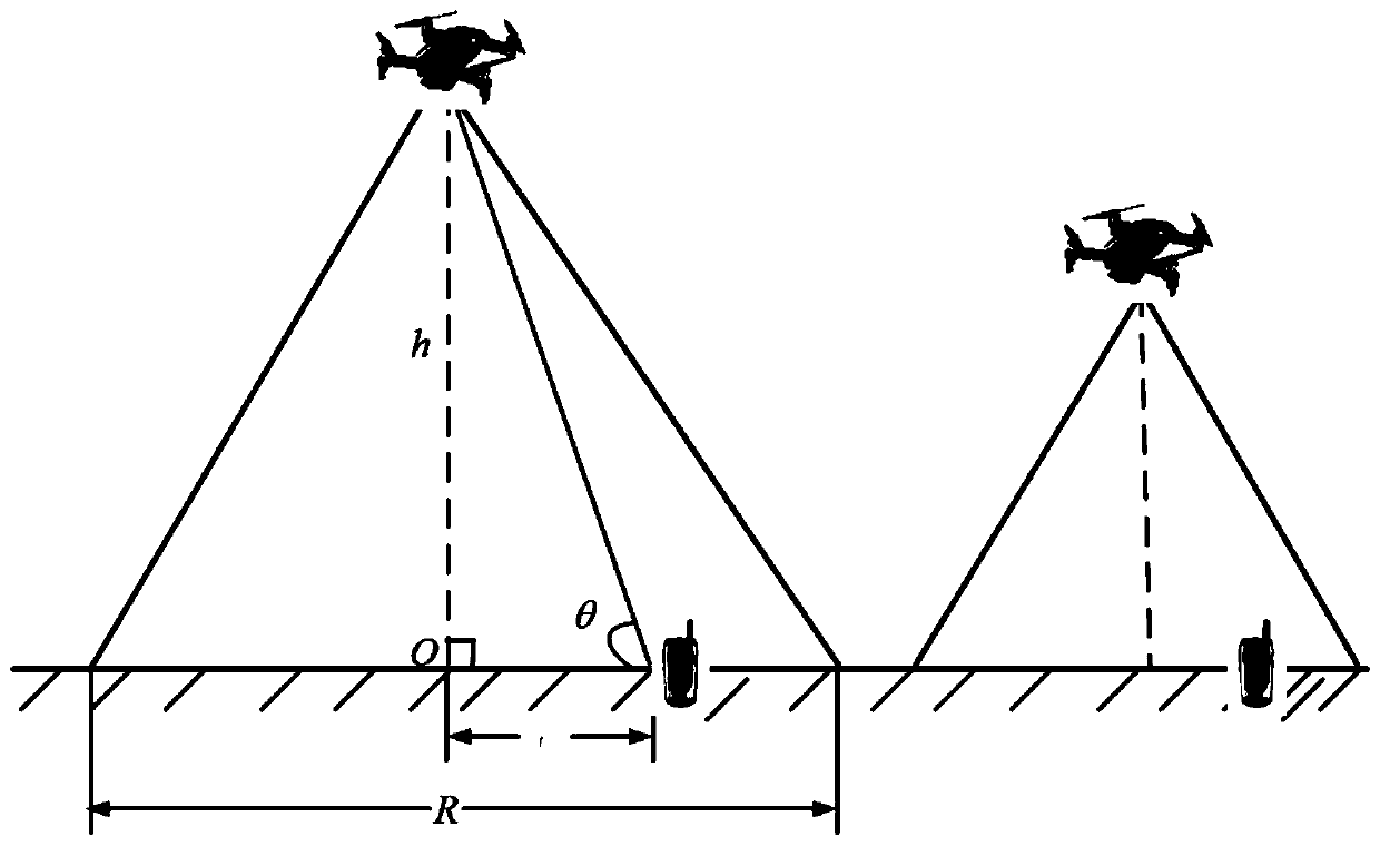
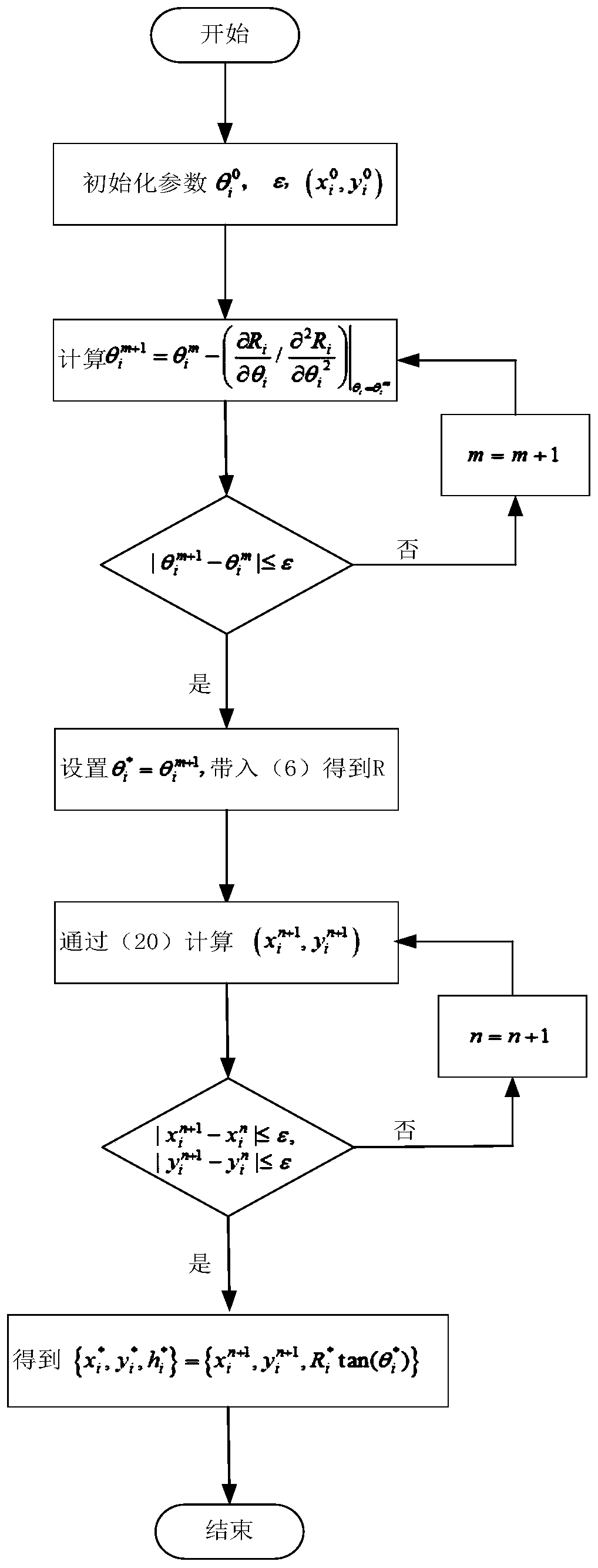
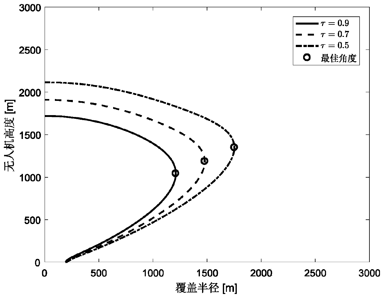
[0064] like Figure 1 to Figure 8 As shown, a multi-UAV base station three-dimensional coordinate calculation method under the channel estimation error includes the following steps:

[0065] Step 1: Establish the channel error model of the UAV base station air-ground link according to the transmission characteristics of the air-ground wireless link,

[0066] Establish the air-to-ground channel model of the UAV base station in the presence of channel errors:

[0067]

[0068] in is the Rice fading channel coefficient, K is the Rice factor, is the scattering component coefficient, △g is the channel error, which obeys the Gaussian distribution with mean value 0 and variance 1, τ∈(0, 1] is the channel error rate, and η is the link path loss. ...


PUM


Abstract

The invention discloses a multi-unmanned aerial vehicle base station three-dimensional coordinate calculation method under a channel estimation error. According to wireless transmission characteristics of an air-ground link between an unmanned aerial vehicle base station and a ground user, a probability-based unmanned aerial vehicle air-ground link channel error model is established, and a multi-unmanned aerial vehicle base station three-dimensional coordinate optimization problem taking a ground user coverage rate as an optimization target and taking a signal transmission interruption probability as a constraint condition is constructed. An unmanned aerial vehicle base station signal transmission outage probability analytical expression under a channel estimation error is deduced; a proposed macro Q inverse function approximate calculation method is combined; obtaining a dominant expression between the pitch angle and the coverage radius of the unmanned aerial vehicle base station; furthermore, the three-dimensional coordinate optimization problem of the unmanned aerial vehicle base station is equivalently split into two sub-optimization problems taking a pitch angle and a groundtwo-dimensional coordinate as optimization variables, and a combined iterative algorithm based on a Newton method and a sequence convex approximation method is provided, so that the three-dimensionalcoordinates of the multiple unmanned aerial vehicle base stations under the maximum user coverage rate can be effectively calculated.

Description

technical field [0001] The invention relates to the technical field of UAV communication, in particular to a method for calculating three-dimensional coordinates of multi-UAV base stations under channel estimation errors. Background technique: [0002] As a recently emerging wireless communication method, the UAV communication base station has the characteristics of strong functional compatibility, flexible construction of communication equipment according to task requirements, no communication blind spots, low cost, and wide coverage, and has been widely used in civilian and military applications. field. Especially for communication scenarios such as forest patrol, traffic monitoring, cargo transportation, and temporary battlefields, traditional base station cellular communication networks cannot effectively solve the problem of network coverage changes caused by fast-moving demands due to coverage limitations. In order to solve this problem, the communication coverage can...

Claims


Application Information

Patent Timeline
IPC IPC(8): H04W16/18H04W64/00H04B17/391
CPCH04W16/18H04W64/006H04B17/391
Inventor 王波欧阳键贾丽燕陈玉婷朱卫平
Owner NANJING UNIV OF POSTS & TELECOMM
Why Eureka
Try Eureka