Indoor positioning and navigation method based on BIM and computer vision technologies

A computer vision and indoor positioning technology, applied in the directions of surveying and mapping, navigation, navigation, and navigation calculation tools, etc., can solve the problems of difficult reception, promotion and application of GNSS signals

Active Publication Date: 2020-04-17
SOUTH CHINA UNIV OF TECH
View PDF6 Cites 7 Cited by
  • Summary
  • Abstract
  • Description
  • Claims
  • Application Information

AI Technical Summary

Problems solved by technology

In the indoor environment, the global navigation satellite system (GNSS) signal is difficult to receive, and it is difficult to promote the application in indoor positioning
[0005] At present, indoor positioning and navigation is still in its infancy, and there is a big gap in the positioning and navigation methods that make full use of prior information and combine BIM and computer vision technology.

Method used


Image

  • Indoor positioning and navigation method based on BIM and computer vision technologies
  • Indoor positioning and navigation method based on BIM and computer vision technologies
  • Indoor positioning and navigation method based on BIM and computer vision technologies

Examples


Embodiment 1

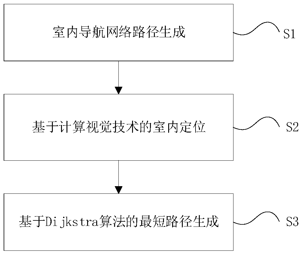
[0059] An indoor positioning and navigation method based on BIM and computer vision technology, such as figure 1 shown, including steps:

[0060] Step 1. Generate the indoor navigation network path based on the BIM model, set the custom attributes of the internal space entity of the building to generate an IFC file, analyze and extract the geometric space components and their topological relationships through the IFC file analysis, and generate a geometric topological network model;

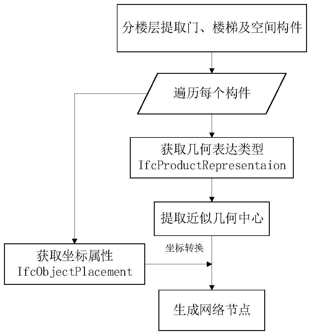
[0061] Preferably, the step of generating a geometric topology network model in the step 1, such as figure 2 As shown, specifically:

[0062] Step 11, extract doors, stairs and space components by floors;

[0063] Step 12, traverse each component, in the IFC file, obtain the IFC Product subclass geometric expression type IFCProduct Representation; extract the approximate geometric center, and extract the coordinates of the vertices in the X and Y directions from the geometric model of each com...


PUM


Abstract

The invention discloses an indoor positioning and navigation method based on BIM and computer vision technologies. The method comprises steps of generating an indoor navigation network path based on aBIM (Building Information Model), setting a customized attribute of an internal space entity of a building to generate an IFC file, and analyzing and extracting a geometric space component and the topological relation thereof through the IFC file to generate a geometric topological network model; achieving indoor positioning based on the computer vision technology, carrying out preliminary positioning through an image recognition method, and then achieving positioning calculation by applying a projection imaging principle in combination with the preset prior information; connecting a positioning point with the geometric topology network model, obtaining a user interest point, and generating a shortest path. The method is advantaged in that low-cost, dynamic and visual indoor positioning navigation can be realized.

Description

technical field [0001] The invention relates to the field of three-dimensional positioning and navigation, in particular to an indoor positioning and navigation method based on BIM and computer vision technology. Background technique [0002] With the acceleration of urbanization, there is an increasingly urgent need for indoor positioning and navigation for complex indoor location services such as commercial centers, parking lots, and hospitals, as well as security management for underground spaces. At this stage, the indoor positioning and navigation process is usually oriented to two-dimensional maps, which is difficult to meet people's daily needs. [0003] Compared with traditional CAD technology, BIM (Building Information Modeling, referred to as BIM) can restore the texture information of building components, rich semantic information and the relationship between them, and support the data sharing of the whole life cycle. IFC (Industry Foundation Classes) is the main...

Claims


Application Information

Patent Timeline
Patent Type & Authority Applications(China)
IPC IPC(8): G01C21/20
CPCG01C21/206
Inventor 邓晖邓逸川张根杰刘沐筠蔡梓淇杨博闻杨士彬王煜
Owner SOUTH CHINA UNIV OF TECH
Why Eureka
Try Eureka