Multi-layer aggregation method and system for displaying massive vehicle position distribution information

A technology of distributing information and aggregation methods, applied in the field of vehicle location display, which can solve problems such as dense vehicles, browser crashes, and lack of quantitative data

Pending Publication Date: 2020-04-17
QIANXUN SPATIAL INTELLIGENCE INC
View PDF8 Cites 5 Cited by
  • Summary
  • Abstract
  • Description
  • Claims
  • Application Information

AI Technical Summary

Problems solved by technology

[0005] 1. There are too many vehicles, the distribution of vehicles is directly displayed, and the information is not focused enough; for example, there are a total of about 1.5 million shared bicycles in Shanghai, and the display effect is as follows figure 1 shown
[0006] 2. During peak hours, vehicles are too dense and there is a lack of quantitative data;
[0007] 3. The client frequently renders a large number of entity points, resulting in a very high system load, and even browser crashes.

Method used


Image

  • Multi-layer aggregation method and system for displaying massive vehicle position distribution information
  • Multi-layer aggregation method and system for displaying massive vehicle position distribution information
  • Multi-layer aggregation method and system for displaying massive vehicle position distribution information

Examples


Embodiment 1

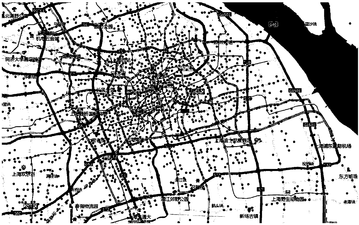
[0056] The present invention provides a multi-layer aggregation method for displaying mass vehicle location distribution information. The whole multi-layer aggregation process will involve two roles of "browser end" and "server end", such as Figure 5 As shown, the detailed data interaction process is as follows:

[0057] 1. getAggregationData (get aggregated data). This process is mainly a request initiated by the browser to obtain the aggregated data of each administrative region. The returned data should include: administrative area name, area code, total number of vehicles and other information. Normally, the parameters that need to be submitted in this step include: the range window of the current map window (including the latitude and longitude of the upper left corner and lower right corner of the window), the zoom level of the map, and so on.

[0058] 2. getBikePostion (get vehicle position information). When the zoom level of the map on the browser side exceeds the...

Embodiment 2

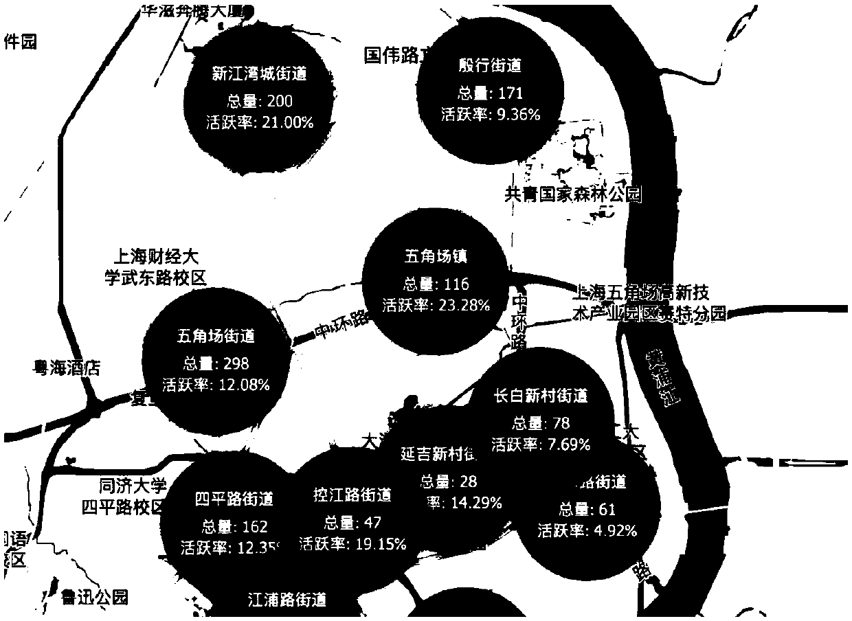
[0084] The present invention provides a multi-layer aggregation system for displaying mass vehicle position distribution information, the multi-layer aggregation system includes a browser end and a server end, the browser end submits the range of the current map window and map zoom level parameters to the server end Initiate an aggregated data request to obtain the aggregated data of each administrative region; the browser continues to submit the range of the current map window, and when the zoom level of the map on the browser exceeds the street level, the aggregated data of the server is no longer used, and the vehicle location information is sent to the server Request to obtain the vehicle data within the current map window from the server; the server returns the vehicle data to the browser, and the browser aggregates the browser based on the quadtree algorithm after receiving the returned vehicle data.

[0085] Further, the browser side jointly decides whether to perform br...

Embodiment 3

[0092] The present invention also provides a memory, the memory stores a computer program, and the computer program is executed by the processor as follows:

[0093] The browser submits the parameters of the current map window range and map zoom level, and initiates an aggregated data request to the server to obtain the aggregated data of each administrative region;

[0094] The browser continues to submit the range of the current map window. When the zoom level of the map on the browser side exceeds the street level, the aggregation data of the server is no longer used, and a vehicle location information request is sent to the server to obtain vehicle data within the current map window from the server. ;

[0095] The server returns the vehicle data to the browser. After the browser receives the returned vehicle data, it performs browser aggregation according to the quadtree algorithm.

[0096] In an alternative solution of the present invention: increase the aggregation leve...


PUM


Abstract

The invention provides a multi-layer aggregation method and system for displaying massive vehicle position distribution information, and the method comprises the following steps: a browser end submitsthe range of a current map window and map scaling level parameters, initiates an aggregation data request to a server end, and obtains the aggregation data of each administrative region; the browserend continues to submit the range of the current map window, when the map zoom level of the browser end exceeds the street, aggregated data of the server end is not used any more, a vehicle position information request is initiated to the server end, and vehicle data in the range of the current map window are obtained from the server end; and the server end returns the vehicle data to the browserend, and the browser end performs browser aggregation according to a quadtree algorithm after receiving the returned vehicle data. According to the invention, the position distribution information ofmassive vehicles can be displayed more friendly and faster.

Description

technical field [0001] The invention relates to the technical field of vehicle location display, in particular to a multi-layer aggregation method and system for displaying mass vehicle location distribution information. Background technique [0002] Similar location-based supervision platforms such as shared bicycles usually use a B / S architecture (Browser / Server, browser / server mode). The core function is to view the location distribution information of vehicles in real time based on electronic maps. Based on this information, it is judged whether there is an oversupply of vehicles, a shortage of supply, entering a no-parking area, or not parking according to regulations, etc., and then sends out an alarm message and performs offline processing. At present, the bicycle supervision platform is mainly used by the government to supervise the parking of shared bicycles. [0003] As one of the most commonly used means of public transportation, shared bicycles have very obvious...

Claims


Application Information

Patent Timeline
Patent Type & Authority Applications(China)
IPC IPC(8): G06F16/957G09B29/00
CPCG09B29/006
Inventor 肖应军
Owner QIANXUN SPATIAL INTELLIGENCE INC
Why Eureka
Try Eureka