Two-dimensional visualized demonstration system for smart cities

A display system and city technology, applied in the field of two-dimensional visualization, can solve the problems of insufficient two-dimensional visualization display functions of smart cities, and achieve the effect of rapid display and comprehensive functions

Pending Publication Date: 2017-06-13
湖北省基础地理信息中心(湖北省北斗卫星导航应用技术研究院)
View PDF4 Cites 7 Cited by
  • Summary
  • Abstract
  • Description
  • Claims
  • Application Information

AI Technical Summary

Problems solved by technology

The existing two-dimensional visual display functions of s

Method used


Image

  • Two-dimensional visualized demonstration system for smart cities

Examples


Embodiment Construction

[0028] The present invention will be further described below in conjunction with the examples, but not as a basis for limiting the present invention.

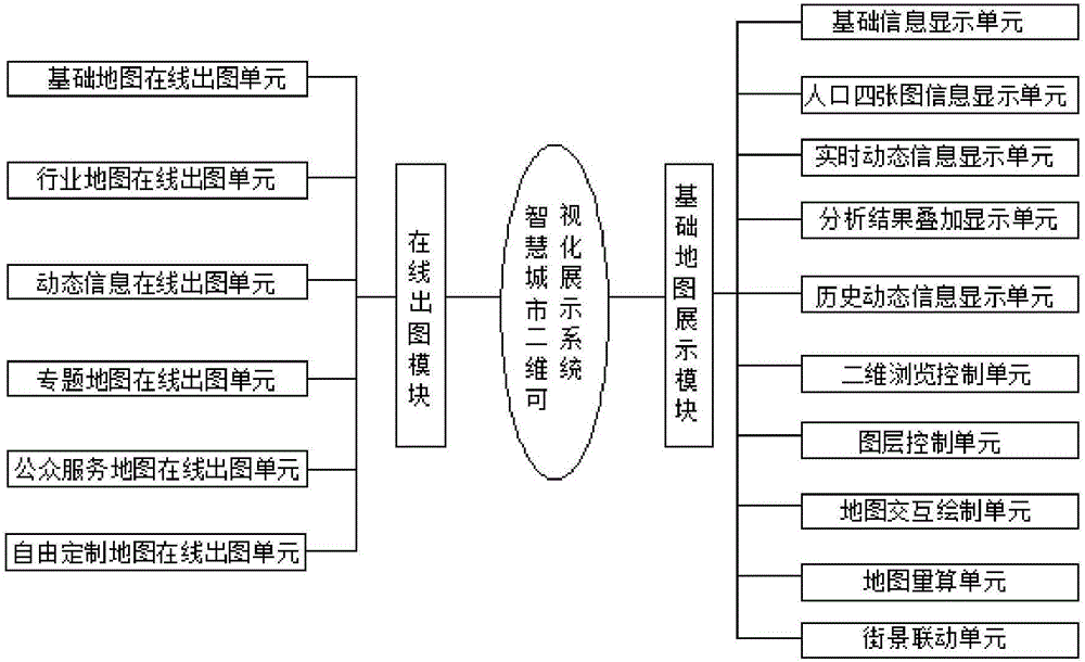
[0029] A smart city two-dimensional visualization display system, such as figure 1 As shown, including the basic map display module and the online drawing module, in which:

[0030] The basic map display module is used for browsing of two-dimensional basic geographic information and real-time display of urban dynamic information;

[0031] The online drawing module is used for displaying online drawing services.

[0032] The smart city two-dimensional visual display system is responsible for the display of two-dimensional chart information, including the browsing of two-dimensional basic geographic information, the real-time display of urban dynamic information, and the display of online mapping services, etc.

[0033] Further, the basic map display module includes a basic information display unit, a population four-map inform...


PUM


Abstract

The invention discloses a two-dimensional visualized demonstration system for smart cities. The two-dimensional visualized demonstration system comprises a basic map demonstration module and an online plotting module. The basic map demonstration module is used for browsing two-dimensional basic geographic information and demonstrating dynamic city information in real time; the online plotting module is used for demonstrating online map making service. The basic map demonstration module comprises a basic information display unit, a population four-map information display unit, a real-time dynamic information display unit, an analysis result overlaying display unit, a historical dynamic information display unit, a two-dimensional browsing control unit, a map layer control unit, a map interactive making unit, a map measuring unit and a street scene linkage unit. The two-dimensional visualized demonstration system has the advantages that the two-dimensional visualized demonstration system has comprehensive functions, the two-dimensional basic geographic information and the dynamic city information of the smart cities can be quickly demonstrated, and basic maps, industrial maps, dynamic information, thematic maps, public service maps and freely customized maps can be vividly and conveniently plotted in an online manner.

Description

technical field [0001] The invention belongs to the technical field of two-dimensional visualization, and in particular relates to a two-dimensional visualization display system for a smart city. Background technique [0002] Smart city is a new concept and new model of current urban development. It is the inevitable result of the development of digital city to a certain stage and the continuous development of scientific and technological progress. It is of great significance to the realization of people-oriented, comprehensive, coordinated and sustainable scientific development of cities. The construction of a smart city requires the construction of a space-time information cloud platform to realize the interconnection of basic space-time information data, resource business data, and real-time dynamic data. Based on these data, a "holographic map" service and achievement exchange system is formed to realize a one-stop platform service. [0003] The continuous enhancement o...

Claims


Application Information

Patent Timeline
IPC IPC(8): G06F17/30G06Q50/26
CPCG06F16/29G06Q50/26
Inventor 郑丽娜黄冠宇杜新石永阁聂小波王海侠程蕾沈凤娇曹晶段艳
Owner 湖北省基础地理信息中心(湖北省北斗卫星导航应用技术研究院)
Why Eureka
Try Eureka